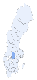
Örebro län
| |||||
| Administrationscentrum | Örebro | ||||
| Landskap: | Närke, Västmanland, Västergötland og Värmland | ||||
| Areal: | 8.517 km² | ||||
| Befolkning: | 273.920 () | ||||
| Befolkningstæthed: | 32 | ||||
Örebro län er et län (amt) i det centrale Sverige. Det grænser op til Västra Götalands län, Värmlands län, Dalarnas län, Västmanlands län, Södermanlands län og Östergötlands län.
Større byer
De ti største byer i Örebro län, sorteret efter indbyggertal:
| # | Byområde | Befolkning |
|---|---|---|
| 1 | Örebro | 98.237 |
| 2 | Karlskoga | 27.500 |
| 3 | Kumla | 13.033 |
| 4 | Lindesberg | 8.752 |
| 5 | Degerfors | 7.418 |
| 6 | Hallsberg | 7.122 |
| 7 | Nora | 6.496 |
| 8 | Hällefors | 4.797 |
| 9 | Askersund | 3.937 |
| 10 | Kopparberg | 3.189 |
Indbyggertal pr. 31. december 2005, Statistiska centralbyrån (SCB).
Eksterne henvisninger
| |||||||||||||
Koordinater: 59°16′00″N 15°13′00″Ø / 59.266667°N 15.216667°Ø
|
Medier brugt på denne side
Forfatter/Opretter: Lokal_Profil, Licens: CC BY-SA 2.5
Map Swedish Counties, Örebro.
Forfatter/Opretter: No machine-readable author provided. Fred J assumed (based on copyright claims)., Licens: CC BY-SA 2.5


