Yell
| Yell | |
|---|---|
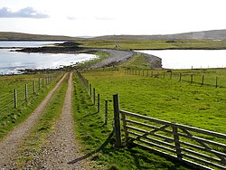
(c) Stuart Wilding, CC BY-SA 2.0 Ayre of Galtagarth. | |
| Geografi | |
Contains Ordnance Survey data © Crown copyright and database right, CC BY-SA 3.0 Yell | |
| Sted | Shetlandsøerne. |
| Koordinater | 60°37′22″N 1°06′00″V / 60.62278°N 1.10000°V |
| Areal | ca. 212 km² |
| Højeste punkt | 210 m |
| Administration | |
| Land | Skotland |
| Demografi | |
| Folketal | 966 (2013) |
Yell 966 indb. (2013) 27 km lang og 11 km bred, er en nordlig ø på Shetlandsøerne. Øen har en god infrastruktur med forretninger, fritidscentrum, tre skoler, et rigt musikliv og en pub. Der er sandstrande, klippelandskaber og et rigt fugle- og dyreliv. Yell er kendt for sine mange oddere. Færgen sejler fra Ulsta til Mainland, fra Gutcher til Belmont på Unst og til Oddsta på Fetlar. Andre landsbyer på Yell er Burravoe med museum, Mid Yell, Cullivoe og Gloup.
Old Haa Museum, der er indrettet i en gammel købmandshus, fortæller om øen og landsbyen Burravoes historie.
Ekstern henvisning
| Spire |
Medier brugt på denne side
Contains Ordnance Survey data © Crown copyright and database right, CC BY-SA 3.0
Relief map of the Shetland Islands, UK.
Equirectangular map projection on WGS 84 datum, with N/S stretched 200%
Geographic limits:
- West: 2.15W
- East: 0.70W
- North: 60.88N
- South: 59.50N
Forfatter/Opretter:
- Scotland_location_map.svg: NordNordWest
- Flag_of_Scotland.svg: Kbolino
- derivative work: Fry1989 (talk) 21:12, 25 January 2011 (UTC)
Flag map of Scotland
(c) Stuart Wilding, CC BY-SA 2.0
Ayre of Galtagarth Track down to the Ayre of Galtagarth and the Ness of Galtagarth beyond.


