Washington County (North Carolina)
 Der er flere lokaliteter med dette navn, se Washington County.
| Washington County, North Carolina | |
| Kort | |
 Placering i delstaten North Carolina | |
 North Carolinas placering i USA | |
| Basis data | |
| Grundlagt | 1799 |
|---|---|
| Hovedby | Plymouth ( North Carolina) |
| Areal - I alt - Land - Vand | 1.009 km² 903 km² 197 km² |
| Befolkningstal - år 2000 Befolkningstæthed | 13.723 15 indb/km² |
| Hjemmeside: www.washingtoncountygov.com | |
| Opkaldt efter: George Washington | |
Washington County er et county i delstaten North Carolina i USA med et indbyggertal på 13.723. Hovedbyen er Plymouth.
Historie
Washington County blev etableret i 1799, hvor den vestlige tredjedel af Tyrrell County blev overført til det nye county, der blev opkaldt efter George Washington.
Geografi
Ifølge den officielle angivelse har Washington County et samlet areal på 1.099 km², hvoraf 197 km² (17.89%) er vand.
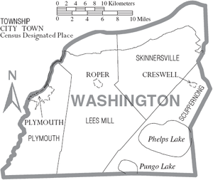
Washington County er delt mellem tre byer Plymouth (administrationscentrum), Roper og Creswell.
Tilgrænsende counties
- Chowan County, North Carolina – nord (over Albemarle Sound)
- Perquimans County, North Carolina – nordøst (over Albemarle Sound)
- Tyrrell County, North Carolina – øst
- Hyde County, North Carolina – sydøst
- Beaufort County, North Carolina – sydvest
- Martin County, North Carolina – vest
- Bertie County, North Carolina – nordvest
Byer
- Creswell
- Plymouth
- Roper
Eksterne henvisninger
Koordinater: 35°50′N 76°33′V / 35.833°N 76.550°V
| ||||||||
|
Medier brugt på denne side
Map of Washington County, North Carolina, United States with township and municipal boundaries
Forfatter/Opretter: This version: uploader
Base versions this one is derived from: originally created by en:User:Wapcaplet, Licens: CC BY 2.0
Map of USA with North Carolina highlighted
This is a locator map showing Washington County in North Carolina. For more information, see Commons:United States county locator maps.


