Virungabjergene
| Virungabjergene | |
|---|---|
 Toppen af Mount Mikeno | |
| Højeste punkt | |
| Bjergtop | 4.507 (Mount Karisimbi) |
| Koordinater | 01°25′45″S 29°32′54″Ø / 1.42917°S 29.54833°Ø |
| Dimensioner | |
| Længde | 80 km[1] |
| Geografi | |
 Virungabjergene | |
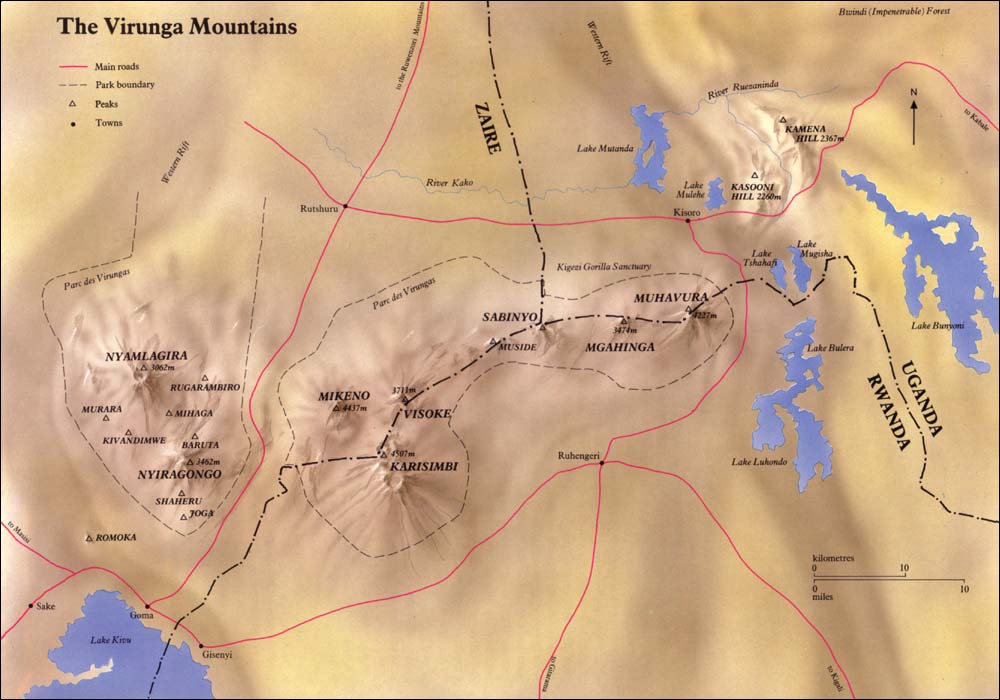
Virungabjergene (også kendt som Mufumbiro[1]) er en kæde af vulkaner i Østafrika, i området hvor Rwanda, Den Demokratiske Republik Congo (DRC) og Uganda mødes. Bjergkæden er en gren af Albertine Rift Mountains, som grænser op til vestsiden af den østafrikanske Rift. De ligger mellem Edwardsøen og Kivusøen. Navnet "Virunga" er en engelsk version af ordet ibirunga på Kinyarwanda, som betyder "vulkaner".


Bjergkæden består af otte store vulkaner. På nær Mount Nyiragongo 3.462 moh. og Mount Nyamuragira 3.063 moh. begge i DRC, er de i dvale. De seneste udbrud fandt sted i 2006, 2010 og maj 2021. Mount Karisimbi er med 4.507 moh. den højeste vulkan. Det ældste bjerg er Mount Sabyinyo, der er 3.634 moh.
Virungabjergene er hjemsted for den truede art bjerggorilla, der er opført på IUCNs rødliste, på grund af tab af levesteder, krybskytteri, sygdom og krig (Butynski et al. 2003). Karisoke Research Center, der blev grundlagt i 1967, af Dian Fossey for at observere gorillaer i deres oprindelige habitat, ligger mellem Mount Karisimbi og Mount Bisoke.
Nationalparker
- Virunga nationalpark (verdensarv), Den Demokratiske Republik Congo
- Volcanoes nationalpark, Rwanda
- Mgahinga Gorilla nationalpark, Uganda
I kulturen
- Michael Crichtons roman Congo foregår hovedsageligt i Virunga-regionen.
- Filmen Gorillas in the Mist og romanen af samme navn dokumenterer primatologen Dian Fosseys arbejde og død. Lejren, hvorfra hun opererede, Karisoke Research Center, eksisterer stadig i Virungabjergene.
Referencer
- Chisholm, Hugh, red. (1911). . Encyclopædia Britannica (11. udgave). Cambridge University Press.
Medier brugt på denne side

a map symbol for a mountain, the center is in the middle of the base line - as opposed to Fire.svg
Forfatter/Opretter: Marfinan, Licens: CC BY 3.0
The Virunga mountain peaks taken from the vicinity of Kisoro, Uganda. From left to right, Muhabura, Gahinga, Karisimbi, Sabyinyo, Mikeno.
Forfatter/Opretter: User:Amakuru, Licens: CC BY-SA 3.0
Mount Gahinga and Mount Muhabura, on the Rwanda/Uganda border
(c) Ishidro, CC BY-SA 3.0
The Stratovolcano Nyiragongo in the Democratic Republic of Congo.
Forfatter/Opretter: Uwe Dedering, Licens: CC BY-SA 3.0
Relief location map of Democratic_Republic_of_the_Congo.
- Projection: Equirectangular projection, stretched by 100.0%.
- Geographic limits of the map:
- N: 6.0° N
- S: -14.0° N
- W: 11.0° E
- E: 32.0° E
- GMT projection: -JX19.473333333333333cd/18.546031746031744cd
- GMT region: -R11.0/-14.0/32.0/6.0r
- GMT region for grdcut: -R11.0/-14.0/32.0/6.0r
- Relief: SRTM30plus.
- Made with Natural Earth. Free vector and raster map data @ naturalearthdata.com.
The summit of Mont Mikeno in the Virunga Mountains. Altocumulus lenticularis clouds form around the top of the mountain.