Virginia Beach
| Virginia Beach Virginia Beach | |||
|---|---|---|---|
| |||
 | |||
| Overblik | |||
| Land | |||
| Motto | Landmarks of Our Nation's Beginning | ||
| Borgmester | Will Sessoms | ||
| Delstat | Virginia | ||
| Grundlagt | 1906 | ||
| Postnr. | 23451 | ||
| Telefonkode | 757 | ||
| Demografi | |||
| Indbyggere | 448.479 (2013)[1] | ||
| - Areal | 1.289 km² | ||
| - Befolkningstæthed | 348 pr. km² | ||
| Andet | |||
| Tidszone | Eastern Time Zone | ||
| Højde m.o.h. | 6 m | ||
| Hjemmeside | www.vbgov.com | ||
| Oversigtskort | |||
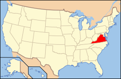
| Virginias beliggenhed i USA | |||
Virginia Beach er den største by i den amerikanske stat Virginia. Byen har 448.479(2013)[1] indbyggere, og ligger ved Chesapeake Bays udmunding. Byen er en independent city, og tilhører ikke noget county. Denne lokaladministrative ordning er udbredt i Virginia, men ikke særlig kendt i resten af USA.
Byen er kendt for at have verdens længste sandstrand. De største erhverv er turisme og militærbaser.
Referencer
- ^ a b www.census.gov (fra Wikidata).
Eksterne henvisninger
| Spire |
|
Medier brugt på denne side
Forfatter/Opretter: SchuminWeb, Licens: CC BY-SA 3.0
One of the best places to travel, The Virginia Beach oceanfront, boardwalk, and hotels as seen from the Fishing Pier.
(c) Lokal_Profil, CC BY-SA 2.5
Map showing Mainland USA ("lower 48") with a superimposed US flag.
Forfatter/Opretter: Alexrk2, Licens: CC BY 3.0
Location map of Virginia, USA
The council accepted the design for a new city flag of Virginia Beach, Virginia, on January 11, 1965. The design was chosen by a three-member flag committee. The flag design was modeled after the flag of the Commonwealth of Virginia, with a solid blue background with the official city seal placed in the center.


