Virgin Gorda
Virgin Gorda er den tredjestørste (efter Tortola og Anegada) og næstmest folkerige af de britiske Jomfruøer. Den dækker et område på cirka 8 kvadratmiles (21 km²). Christopher Columbus siges at have kaldt øen "The Fat Virgin" (den fede jomfru), fordi øens profil i horisonten ligner en fed kvinde liggende på siden.
Billedgalleri
 oversigt over øen
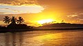 (c) I, Ryansmith714, CC BY-SA 3.0Solnedgang på Virgin Gorda
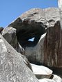 The Baths, Virgin Gorda
 The Baths, fra en anden vinkel
| Spire Denne artikel om nordamerikansk geografi er en spire som bør udbygges. Du er velkommen til at hjælpe Wikipedia ved at udvide den. |
Medier brugt på denne side

VirginGordaTheBaths.jpg
Forfatter/Opretter: Calyponte, Licens: CC BY 3.0
View of the boulders at The Baths in Virgin Gorda, BVI
Forfatter/Opretter: Calyponte, Licens: CC BY 3.0
View of the boulders at The Baths in Virgin Gorda, BVI


VirginGordaOverview.jpg
Forfatter/Opretter: Jcljules, Licens: CC BY 2.5
An Overview of the Island of Virgin Gorda.
Forfatter/Opretter: Jcljules, Licens: CC BY 2.5
An Overview of the Island of Virgin Gorda.

TheBaths RockFormation BritishVirginIslands Feb6-2000.jpg
Forfatter/Opretter: Captmondo, Licens: CC BY-SA 3.0
Picture of the water-eroded rock formations at The Baths, British Virgin Islands. Picture shot February 6th 2000.
Forfatter/Opretter: Captmondo, Licens: CC BY-SA 3.0
Picture of the water-eroded rock formations at The Baths, British Virgin Islands. Picture shot February 6th 2000.

Awsome sun set in the virgin islands.jpg
(c) I, Ryansmith714, CC BY-SA 3.0
Sunset at Road Harbour, Virgin Gorda, British Virgin Islands
(c) I, Ryansmith714, CC BY-SA 3.0
Sunset at Road Harbour, Virgin Gorda, British Virgin Islands