Villiers-le-Bel
| Villiers-le-Bel – fransk kommune (commune) – | |||||
|---|---|---|---|---|---|
| |||||
 Rådhuset i Villiers-le-Bel | |||||
| Land | |||||
| Region | |||||
| Departement | Val-d'Oise | ||||
| Arrondissement | Sarcelles | ||||
| Kanton | Villiers-le-Bel | ||||
| Interkommunal enhed | Communauté d'agglomération Val de France | ||||
| Borgmester | Jean-Louis Marsac (fra 2014) | ||||
| Geografi | |||||
| Koordinater | 49°0′N 2°23′Ø / 49.000°N 2.383°Ø | ||||
| Højde (gns) | 104 m | ||||
| Areal | 7,30 km² | ||||
| Demografi | |||||
| Indbyggere | 27.428 | ||||
| Befolkningstæthed | 3.757 indb./km² | ||||
| Postnummer | 95400 | ||||
| INSEE-kode | 95680 | ||||
| Hjemmeside | www.ville-villiers-le-bel.fr/2/accueil.htm | ||||
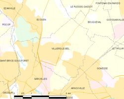
 Kort over kommunen | |||||
Villiers-le-Bel er en kommune hvis befolkning primært består af muslimer med algerisk, tunesisk og marokkansk arv[kilde mangler]. Kommunen ligger i det franske departement Val-d'Oise i de nordlige forstæder til Paris kun 17.4 km fra centrum af Paris.
Eksterne henvisninger
- Officiel hjemmeside (fransk)
| Spire Denne artikel om Frankrigs geografi er en spire som bør udbygges. Du er velkommen til at hjælpe Wikipedia ved at udvide den. |
Medier brugt på denne side
Map showing France with the ch flag.
Cultural flag for the region Île-de-France in France, based on the flag of the kingdom of France (s.XIV-XV). It is neither recognized nor used by public authorities of Île-de-France.
Map showing France with the ch flag.
Forfatter/Opretter:
| This illustration was made by Peter Potrowl.
Please credit this with : © Peter Potrowl in the immediate vicinity of the image. A link to my website sitemai.eu would be much appreciated but isn't mandatory. An email to
Do not copy this image illegally by ignoring the terms of the license below, as it is not in the public domain.
If you would like special permission to use, license, or purchase the image please contact me More free pictures in my website. Donations are accepted here and here. |
City hall of Villiers-le-Bel (Val-d'Oise, France).
Forfatter/Opretter:
|
Map data (c) OpenStreetMap contributors, CC-BY-SA  • Shape files infrastructure: railway, highways, water: all originally by OpenStreetMap contributors. Status december 2011 *note: shown commune boundaries are from OSM dump May 2012; at that time about 90% complete |
Map of French municipality Villiers-le-Bel


