Vale of Glamorgan
Vale of Glamorgan (walisisk: Bro Morgannwg ofte omtalt som The Vale, er et county borough i det sydøstlige Wales. Det grænser op til Bridgend County Borough mod vest, Cardiff mod øst, Rhondda Cynon Taf mod nord og Bristolkanalen mod syd.
Områdets økonomi er hovedsageligt baseret på landbrug og kemikalier. Det attraktioner inluderer Barry Island Pleasure Park, Barry Tourist Railway, middelalderlige vægmalerier i St Cadoc's Church, Porthkerry Park, St Donat's Castle, Cosmeston Lakes Country Park ogCosmeston Medieval Village. Den største by er Barry, mens andre byer inkluderer Penarth, Llantwit Major og Cowbridge.
Communities
Alle Vales communities har et byråd, bortset fra Rhoose, som den laveste del af lokalregeringen.[1]
- Barry (by)
- Colwinston
- Cowbridge with Llanblethian (by)
- Dinas Powys
- Ewenny
- Llanmaes
- Llancarfan
- Llandough
- Llandow
- Llanfair
- Llangan
- Llantwit Major (by)
- Michaelston-le-Pit and Leckwith
- Penarth (by)
- Pendoylan
- Penllyn
- Peterston-super-Ely
- Rhoose
- St Athan
- St Bride's Major
- St Donats
- St Georges-super-Ely
- St Nicholas and Bonvilston
- Sully and Lavernock
- Welsh St Donats
- Wenvoe
- Wick
Referencer
- ^ "Town and Community Councils". Vale of Glamorgan Council. Hentet 29. juni 2021.
Eksterne henvisninger
| Spire |
51°25′00″N 3°25′00″V / 51.416666666667°N 3.4166666666667°V
Medier brugt på denne side
Forfatter/Opretter:
- Wales_location_map.svg: NordNordWest
- Flag_of_Wales_2.svg:
- derivative work: Fry1989 eh? 20:04, 8 December 2011 (UTC)
Flag map of Wales
Contains Ordnance Survey data © Crown copyright and database right, CC BY-SA 3.0
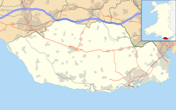
Blank map of the Vale of Glamorgan, UK with the following information shown:
- Administrative borders
- Coastline, lakes and rivers
- Roads and railways
- Urban areas
Equirectangular map projection on WGS 84 datum, with N/S stretched 160%
Geographic limits:
- West: 3.66W
- East: 3.15W
- North: 51.55N
- South: 51.35N


