USA's delstater
Amerikas Forenede Stater, eller USA, består af 50 delstater. Hver delstat har sit eget parlament, som oftest består af to kamre, samt egne domstole og en folkevalgt guvernør. De enkelte delstatsregeringer og den amerikanske forbundsregering deler suverænitet idet en amerikaner er borger i både den lokale delstat og den føderale republik. Delstatsborgerskab er dog meget åbent og ingen statsgodkendelse kræves for at flytte mellem de individuelle delstater (med undtagelse for dømte, der er prøveløsladt). Delstaterne har en række delstatssymboler, så som deres egne flag.
Hovedstaden Washington, D.C. (ikke at forveksle med delstaten Washington) er ikke en delstat, men udgør sit eget føderale distrikt, der kontrolleres af den føderale regering. Derudover besidder USA adskillige territorier, hvoraf fem er befolkede: Amerikansk Samoa, Amerikanske Jomfruøer (det tidligere Dansk Vestindien), Guam, Nordmarianerne, og Puerto Rico. Befolkningen i Washington og alle territorierne på nær Amerikansk Samoa er amerikanske statsborgere. Kun borgere i Washington og de 50 delstater kan stemme ved præsidentvalg, og kun borgere i de 50 delstater kan stemme ved kongresvalg.
Delstater

Liste over delstater
Dette er en oversigt over USA's delstater med forskellige oplysninger.
| Delstat | Flag | Forkortelse | Hovedstad | Største by | Guvernør | Landareal (km2) | Befolkning (2020) | Befolknings- tæthed (indb./km2) | Indtrædel- sesdato | Tidszone | Højeste punkt | Middelhøjde | Laveste punkt |
|---|---|---|---|---|---|---|---|---|---|---|---|---|---|
| Alabama |  | AL | Montgomery | Birmingham | Kay Ivey (R) | 131.426 | 5.024.279 | 38,2 | 14. december 1819 | Central: UTC -6/-5 | 734 | 152 | 0 |
| Alaska |  | AK | Juneau | Anchorage | Mike Dunleavy (R) | 1.481.347 | 733.391 | 0,5 | 3. januar 1959 | UTC -9 til -10/-8 til -9 | 6.194 | 3.060 | 0 |
| Arizona |  | AZ | Phoenix | Doug Ducey (R) | 294.312 | 7.151.502 | 24,3 | 14. februar 1912 | Mountain: UTC -7 | 3.851 | 1.250 | 21 | |
| Arkansas |  | AR | Little Rock | Asa Hutchinson (R) | 134.856 | 3.011.524 | 22,3 | 15. juni 1836 | Central: UTC -6/-5 | 839 | 198 | 17 | |
| Californien |  | CA | Sacramento | Los Angeles | Gavin Newsom (D) | 403.933 | 39.538.223 | 97,9 | 9. september 1850 | Pacific: UTC -8/-7 | 4.148 | 884 | -86 |
| Colorado |  | CO | Denver | Jared Polis (D) | 268.627 | 5.773.714 | 21,5 | 1. august 1876 | Mountain: UTC -7/-6 | 4.399 | 2.073 | 1.021 | |
| Connecticut |  | CT | Hartford | Bridgeport | Ned Lamont (D) | 12.548 | 3.605.944 | 287,3 | 9. januar 1788 | Eastern: UTC -5/-4 | 725 | 125 | 0 |
| Delaware |  | DE | Dover | Wilmington | John C. Carney Jr. (D) | 5.068 | 989.948 | 195,3 | 7. december 1787 | Eastern: UTC -5/-4 | 137 | 18 | 0 |
| Florida |  | FL | Tallahassee | Jacksonville | Ron DeSantis (R) | 139.670 | 21.538.187 | 154,2 | 3. marts 1845 | Eastern: UTC -6/-5 | 105 | 30 | 0 |
| Georgia | GA | Atlanta | Brian Kemp (R) | 149.976 | 10.711.908 | 71,4 | 2. januar 1788 | Eastern: UTC -5/-4 | 1.458 | 180 | 0 | ||
| Hawaii | HI | Honolulu | David Ige (D) | 16.635 | 1.455.271 | 87,5 | 21. august 1959 | UTC -10 | 4.205 | 925 | 0 | ||
| Idaho |  | ID | Boise | Brad Little (R) | 214.315 | 1.839.106 | 8,6 | 3. juli 1890 | Mountain: UTC -7/-6 Pacific: UTC -8/-7 | 3.859 | 1.524 | 216 | |
| Illinois | IL | Springfield | Chicago | J.B. Pritzker (D) | 143.961 | 12.812.508 | 89,0 | 3. december 1818 | Central: UTC -6/-5 | 376 | 182 | 85 | |
| Indiana |  | IN | Indianapolis | Eric Holcomb (R) | 92.894 | 6.785.528 | 73,0 | 11. december 1816 | Eastern: UTC -5/-4 Central: UTC -6/-5 | 383 | 210 | 98 | |
| Iowa |  | IA | Des Moines | Kim Reynolds (R) | 144.701 | 3.190.369 | 22,0 | 29. december 1846 | Central: UTC -6/-5 | 509 | 335 | 146 | |
| Kansas | KS | Topeka | Wichita | Laura Kelly (D) | 211.900 | 2.937.880 | 13,9 | 29. januar 1861 | Central: UTC -6/-5 Mountain: UTC -7/-6 | 1.231 | 610 | 207 | |
| Kentucky | KY | Frankfort | Louisville | Andy Beshear (D) | 102.896 | 4.505.836 | 43,8 | 1. juni 1792 | Eastern: UTC -5/-4 Central: UTC -6/-5 | 1.262 | 230 | 78 | |
| Louisiana | LA | Baton Rouge | New Orleans | John Bel Edwards (D) | 112.824 | 4.657.757 | 41,3 | 30. april 1812 | Central: UTC -6/-5 | 163 | 30 | -2,5 | |
| Maine |  | ME | Augusta | Portland | Janet Mills (D) | 79.931 | 1.362.359 | 17,0 | 15. marts 1820 | Eastern: UTC -5/-4 | 1.608 | 180 | 0 |
| Maryland |  | MD | Annapolis | Baltimore | Larry Hogan (R) | 25.314 | 6.177.224 | 244,0 | 28. april 1788 | Eastern: UTC -5/-4 | 1.024 | 105 | 0 |
| Massachusetts | MA | Boston | Charlie Baker (R) | 20.305 | 7.029.917 | 346,2 | 6. februar 1788 | Eastern: UTC -5/-4 | 1.063 | 150 | 0 | ||
| Michigan |  | MI | Lansing | Detroit | Gretchen Whitmer (D) | 150.504 | 10.077.331 | 67,0 | 26. januar 1837 | Eastern: UTC -5/-4 | 603 | 275 | 174 |
| Minnesota | MN | Saint Paul | Minneapolis | Tim Walz (DFL) | 206.190 | 5.706.494 | 27,7 | 11. maj 1858 | Central: UTC -6/-5 | 701 | 365 | 183 | |
| Mississippi | MS | Jackson | Tate Reeves (R) | 121.489 | 2.961.279 | 24,4 | 10. december 1817 | Central: UTC -6/-5 | 246 | 90 | 0 | ||
| Missouri | MO | Jefferson City | Kansas City | Mike Parson (R) | 178.413 | 6.154.913 | 34,5 | 10. august 1821 | Central: UTC -6/-5 | 540 | 240 | 70 | |
| Montana |  | MT | Helena | Billings | Greg Gianforte (R) | 376.979 | 1.084.225 | 2,9 | 8. november 1889 | Mountain: UTC -7/-6 | 3.901 | 1.035 | 549 |
| Nebraska | NE | Lincoln | Omaha | Pete Ricketts (R) | 199.099 | 1.961.504 | 9,9 | 1. marts 1867 | Central: UTC -6/-5 og Mountain: UTC -7/-6 | 1.653 | 790 | 256 | |
| Nevada |  | NV | Carson City | Las Vegas | Steve Sisolak (D) | 284.448 | 3.104.614 | 10,9 | 31. oktober 1864 | Pacific: UTC -8/-7 | 4.005 | 1.676 | 146 |
| New Hampshire |  | NH | Concord | Manchester | Chris Sununu (R) | 23.227 | 1.377.529 | 59,3 | 21. juni 1788 | Eastern: UTC -5/-4 | 1.917 | 305 | 0 |
| New Jersey | NJ | Trenton | Newark | Phil Murphy (D) | 19.211 | 9.288.994 | 483,5 | 18. december 1787 | Eastern: UTC -5/-4 | 550 | 75 | 0 | |
| New Mexico |  | NM | Santa Fe | Albuquerque | Michelle Lujan Grisham (D) | 314.309 | 2.117.522 | 6,7 | 6. januar 1912 | Mountain: UTC -7/-6 | 4.011 | 1.735 | 866 |
| New York | NY | Albany | New York | Kathy Hochul (D) | 122.283 | 20.201.249 | 165,2 | 26. juli 1788 | Eastern: UTC -5/-4 | 1.629 | 305 | 0 | |
| North Carolina |  | NC | Raleigh | Charlotte | Roy Cooper (D) | 126.160 | 10.439.388 | 82,7 | 21. november 1789 | Eastern: UTC -5/-4 | 2.037 | 215 | 0 |
| North Dakota |  | ND | Bismarck | Fargo | Doug Burgum (R) | 178.647 | 779.094 | 4,4 | 2. november 1889 | Central: UTC -6/-5 Mountain: UTC -7/-6 | 1.069 | 580 | 229 |
| Ohio | OH | Columbus | Mike DeWine (R) | 106.056 | 11.799.448 | 111,3 | 1. marts 1803 | Eastern: UTC -5/-4 | 472 | 260 | 139 | ||
| Oklahoma |  | OK | Oklahoma City | Kevin Stitt (R) | 177.846 | 3.959.353 | 22,3 | 16. november 1906 | Central: UTC -6/-5 | 1.516 | 395 | 88 | |
| Oregon |  | OR | Salem | Portland | Kate Brown (D) | 248.631 | 4.237.256 | 17,0 | 14. februar 1859 | Pacific: UTC -8/-7 | 3.426 | 1.005 | 0 |
| Pennsylvania |  | PA | Harrisburg | Philadelphia | Tom Wolf (D) | 116.074 | 13.011.844 | 112,1 | 12. december 1787 | Eastern: UTC -5/-4 | 979 | 335 | 0 |
| Rhode Island |  | RI | Providence | Daniel McKee (D) | 2.709 | 1.097.379 | 405,1 | 29. maj 1790 | Eastern: UTC -5/-4 | 247 | 60 | 0 | |
| South Carolina |  | SC | Columbia | Henry McMaster (R) | 77.983 | 5.118.425 | 65,6 | 23. maj 1788 | Eastern: UTC -5/-4 | 1.085 | 105 | 0 | |
| South Dakota | SD | Pierre | Sioux Falls | Kristi Noem (R) | 196.540 | 886.667 | 4,5 | 2. november 1889 | Central: UTC -6/-5 Mountain: UTC -7/-6 | 2.207 | 670 | 294 | |
| Tennessee | TN | Nashville | Memphis | Bill Lee (R) | 106.752 | 6.910.840 | 64,7 | 1. juni 1796 | Eastern: UTC -5/-4 Central: UTC -6/-5 | 2.025 | 275 | 54 | |
| Texas |  | TX | Austin | Houston | Greg Abbott (R) | 678.051 | 29.145.505 | 43,0 | 29. december 1845 | Central: UTC -6/-5 | 2.667 | 520 | 0 |
| Utah | UT | Salt Lake City | Spencer Cox (R) | 212.751 | 3.271.616 | 15,4 | 4. januar 1896 | Mountain: UTC -7/-6 | 4.123 | 1.920 | 610 | ||
| Vermont | VT | Montpelier | Burlington | Phil Scott (R) | 23.956 | 643.077 | 26,7 | 4. marts 1791 | Eastern: UTC -5/-4 | 1.339 | 305 | 29 | |
| Virginia |  | VA | Richmond | Virginia Beach | Ralph Northam (D) | 102.549 | 8.631.393 | 84,2 | 25. juni 1788 | Eastern: UTC -5/-4 | 1.746 | 290 | 0 |
| Washington | WA | Olympia | Seattle | Jay Inslee (D) | 172.348 | 7.705.281 | 44,7 | 11. november 1889 | Pacific: UTC -8/-7 | 4.392 | 520 | 0 | |
| West Virginia | WV | Charleston | Jim Justice (R) | 62.361 | 1.793.716 | 28,8 | 20. juni 1863 | Eastern: UTC -5/-4 | 1.482 | 455 | 73 | ||
| Wisconsin |  | WI | Madison | Milwaukee | Tony Evers (D) | 140.663 | 5.893.718 | 41,9 | 29. maj 1848 | Central: UTC -6/-5 | 595 | 320 | 177 |
| Wyoming |  | WY | Cheyenne | Mark Gordon (R) | 251.489 | 576.851 | 2,3 | 10. juli 1890 | Mountain: UTC -7/-6 | 4.207 | 2.040 | 945 | |
Demografiske og historiske kort
 Staterne efter BNP pr. indbygger
 Staterne efter dato for indtræden i unionen
 HStaterne efter dato for indtræden i unionen - animeret
 Historisk udvikling af unionen - animeret
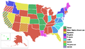 Herkomst af staternes navne
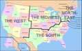 Hovedregioner i USA
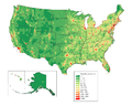 (c) JimIrwin, CC BY-SA 3.0Befolkningstæthed. Klik på kortet for detaljer indenfor den enkelte stat
Se også
- Tidszoner i USA
- USA's delstater efter areal
- USA's delstater efter befolkningsstørrelse
- USA's delstatsflag
- USA's delstatssymboler
- USA's største byer
Kilder
| Wikimedia Commons har medier relateret til: |
|
Medier brugt på denne side
Forfatter/Opretter:
The original was edited by Andrew c to include Nova Scotia, PEI, Bahamas, and scale key.
It was originally uploaded to the English Wikipedia with the same title by Wapcaplet:
- 20:57, 9 October 2005 . . Dbenbenn . . 959x593 (339217 bytes) (fix South Carolina label)
- 20:27, 9 October 2005 . . Dbenbenn . . 959x593 (339227 bytes) (typo, Massachussetts -> Massachusetts)
- 19:01, 9 October 2005 . . Dbenbenn . . 959x593 (371653 bytes) (crop, and remove some shapes (rivers, highways, capitals, lakes) that didn't display anyway)
- 13:18, 23 September 2005 . . Ed g2s . . 990x855 (978668 bytes) (fix (removed <image /> tag))
- 23:48, 23 September 2004 . . Wapcaplet . . 0x0 (978926 bytes) (SVG map of the United States. Created by Wapcaplet. {{GFDL} })
A map of the United States, with state names (and Washington D.C.).

Forfatter/Opretter: Golbez, Licens: CC BY-SA 4.0
Animation of the territorial evolution of the United States.

(c) JimIrwin, CC BY-SA 3.0
United States population density map based on Census 2010 data. See the data lineage for a process description. Also see U.S. state population maps.
ᎡᏩᏐᎾ ᎦᏓᏘ
Flag of California. This version is designed to accurately depict the standard print of the bear as well as adhere to the official flag code regarding the size, position and proportion of the bear, the colors of the flag, and the position and size of the star.


The flag of Minnesota, since May 11, 2024.


The flag of Utah (2024-present). This is the final design submitted for consideration to be adopted as a new state flag of Utah. The design evokes images of snowy mountains and red rocks to represent the geography of Utah, the beehive represents "Industry" (the state's slogan) and Utah's nickname as "the Beehive State".


Forfatter/Opretter: User:Roke~commonswiki, Licens: CC BY-SA 3.0
Animation showing US states by date of statehood, see List of U.S. states by date of statehood for more details. The first thirteen states are shown in the order by the date each ratified the present United States Constitution, the rest show the year of admission to the union in the sliding scale at the bottom.
Note that this shows present day state boundaries, which in some cases do not correspond with the historical boundaries of the state, such as West Virginia which was a part of Virginia until 1861.
Flag of Oregon (obverse): The flag was adopted by the state on February 26, 1925.[1] The state seal was decided in 1903.[2][3]


Forfatter/Opretter: Rocky Vaughn, Sue Anna Joe, Dominique Pugh, Clay Moss, Kara Giles, Micah Whitson and the Mississippi Department of Archives and History, Licens: Copyrighted free use
The flag of the U.S. state of Mississippi - aspect ratio of 5:3. Designed in 2020 and adopted in 2021, the "New Magnolia" flag was selected by the Commission to Redesign the Mississippi state flag in 2020.


Forfatter/Opretter: dcljr, Licens: CC BY-SA 3.0
Yet another version of Image:US_states_by_date_of_statehood.PNG


Flag of the State of Nevada. The flag is described in Nevada Revised Statutes Chapter 235, Sec. 20 as follows: The body of the flag must be of solid cobalt blue. On the field in the upper left quarter thereof must be two sprays of Sagebrush with the stems crossed at the bottom to form a half wreath. Within the sprays must be a five-pointed silver star with one point up. The word “Nevada” must also be inscribed below the star and above the sprays, in a semicircular pattern with the letters spaced apart in equal increments, in the same style of letters as the words “Battle Born.” Above the wreath, and touching the tips thereof, must be a scroll bearing the words “Battle Born.” The scroll and the word “Nevada” must be golden-yellow. The lettering on the scroll must be black-colored sans serif gothic capital letters.

.PNG)


