Tidevandsø


En tidevandsø er et stykke land, der er forbundet til fastlandet ved en naturlig eller menneskeskabt dæmning eller dige, der er oven vande ved lavvande, men oversvømmet ved højvande. På grund af mystikken ved tidevandsøer har mange været stedet for religiøse steder, som eksempelvis Mont Saint-Michel med Benediktinerordenens kloster. Tidevandsøer er også ofte blevet brugt til fæstninger på grund af deres naturligt forskansning.
Liste over tidevandsøer
Asien
Hong Kong
- Ma Shi Chau i Tai Po District, nordøstlige New Territories, inde i Tolo Harbour
Sydkorea
- Jindo og Modo i det sydvestlige Sydkorea
Europa
Kanaløer
- Lihou i Guernsey, en af Kanaløerne
Danmark
- Mandø i Vesterhavet
- Knudshoved – nord for Vordingborg på Sydsjælland, Danmark
Frankrig
- Île Madame i Charente-Maritime
- Île de Noirmoutier i Vendée
- Mont Saint-Michel i Normandiet
- Tombelaine i Normandiet
Irland
- Coney Island nær Rosses Point, County Sligo
- Omey Island i Connemara, County Galway, Connacht
Spanien
- Cortegadaøen i Pontevedrakysten, Galicien.
- San Nikolas Island i Lekeitio, Bizkaia
Storbritannien
- Asparagus Island i Cornwall, England
- Baleshare i de Ydre Hebrider, Skotland
- Brough of Birsay i Orkney, Skotland
- Burgh Island i Devon, England
- Burrow Island i Portsmouth Harbour, England
- Burry Holms på Gower, Wales
- Castle Stalker i Loch Laich i Argyll, Skotland
- Chapel Island i Cumbria, England
- Chiswick Eyot i Themsen
- Cramond Island i Firth of Forth, Skotland
- Davaar Island nær Campbeltown, på Kintyre-halvøen, Skotland
- Eilean Shona i Loch Moidart, Skotland
- Eilean Tioram, i Loch Moidart, Lochaber, Highland, Skotland som Castle Tioram ligger på
- Erraid ud for Isle of Mull i Skotland
- Gateholm ud for sydvestkysten af Pembrokeshire, Wales
- Gugh i Isles of Scilly, Storbritannien
- Hestan Island nær Rough Isalnd i Auchencairn Bay, Skotland
- Hilbre Island, Middle Eye og Little Eye i Dee-flodmundingen, mellem North Wales og den engelske Wirral
- Horsey Island i Essex, England
- Islands of Fleet: Ardwall Isle & Barlocco Isle i Galloway, Skotland
- Isle Ristol, den inderste af Summer Isles i Skotland
- Kili Holm i Orkney, Skotland
- Lindisfarne i Northumberland, England
- Llanddwyn Island ud for Anglesey i North Wales
- Mersea Island i Essex, England
- Mumbles Lighthouse i Mumbles, nær Swansea
- Northey Island i Essex, England
- Oronsay i de Indre Hebrider, Skotland
- Osea Island i Essex, England
- Piel Island i Cumbria, England
- Ray Island i Essex, England
- Rough Island overfor Rockcliffe, Skotland
- Sheep Island i Cumbria, England
- St Catherine's Island i Pembrokeshire, Wales
- St Mary's Island i North Tyneside, England
- St Michael's Mount i Cornwall, Storbritannien
- Sully Island i Vale of Glamorgan, Wales
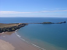
- Worm's Head på Gower, Wales
- Ynys Gifftan i Gwynedd, nordlige Wales
- Ynys Lochtyn på Cardigan Bays kyst, Wales
Der er adgang til 43 tidevandsøer (uden broer) fra Storbritanniens hovedland.[1]
Tyskland
- Halliger i de Nordfrisiske Øer, Tyskland
Nordamerika
Canada
- Micou's Island i St. Margarets Bay, Nova Scotia, Canada
- Minister's Island i New Brunswick, Canada
USA

- Bar Island i Maine
- Battery Point Light i California
- Bumpkin Island i Massachusetts
- Camano Island i Puget Sound i Washington State, siden opfyldt med jord
- Cana Island Lighthouse in Wisconsin
- Charles Island, i Connecticut
- Douglas Island i Alaska
- High Island, New York
- Long Point Island,[2] Harpswell
Oceanien
Australien
- Penguin Island (Western Australia) i Shoalwater Islands Marine Park
- Tidligere tidevandsø Bennelong Island i Sydney, Australien blev udbygget til Bennelong Point og er nu stedet hvor Sydney Opera House ligger.
New Zealand

- Matakana Island i Tauranga Harbour
- Opahekeheke Island i Kaipara Harbour
- Puddingstone Island i Otago Harbour
- Rabbit Island, Bells Island og Bests Island i Tasman Bay
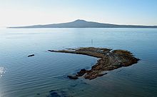
- Hauraki Gulf ved Motutapu Island og Rangitoto Island bliver forbundet ved lavvande
- Okatakata Islands og Walker Island i Rangaunu Harbour
Se også
- Ø
- Holm
Referencer
- ^ Peter Caton (2011). No Boat Required – Exploring Tidal Islands. ISBN 978-1848767-010.
- ^ "longpointisland.com". Arkiveret fra originalen 27. september 2007. Hentet 25. april 2021.
Eksterne henvisninger
Medier brugt på denne side
Forfatter/Opretter: Avenue, Licens: CC BY-SA 3.0
Rangitoto Island forms a backdrop to the wave-cut platform off Achilles Point, Auckland.
Forfatter/Opretter: Clorox, Licens: CC BY-SA 3.0
A diagram of a tidal island at low and high tide.
(c) Ed Iglehart, CC BY-SA 2.0
Rough Island from Tornat Wood A nature reserve under the management of the National Trust for Scotland
Bar Island from Sandy Point, Plum Island, Massachusetts.
Forfatter/Opretter: Mtcv, Licens: CC BY-SA 3.0
Cramond Island and causeway (submerged in this picture, pylons visible). Photo taken from a plane, minutes before landing at Edinburgh Airport. I cropped out parts of the photo where the landing gear etc was showing, but I felt I had to leave in the top of the photo where a part of the wing is present, because I wanted the horizon and the other side of the firth to remain visible.
Forfatter/Opretter: Luca Deboli, Licens: CC BY 2.0
As a request from Mr. Jiyoung, Fashion Lab, Kookmin University, Korea I am putting this image under the Attribution license hereafter. You are free to use it under this license.
(c) CharlesC at engelsk Wikipedia, CC BY-SA 3.0
Worm's Head, Gower. Taken while flying a paraglider over Rhossili Down


