Texarkana (Arkansas)
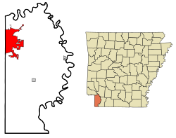
Texarkana er en amerikansk by og administrativt centrum for det amerikanske county Miller County i staten Arkansas. I 2005 havde byen et indbyggertal på 30.006.
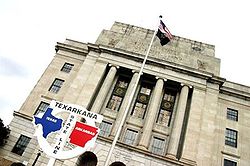
Texarkana ligger på grænsen mellem Texas og Arkansas og har navn efter disse to stater samt Louisiana, der ligger lidt sydligere.
Se også
- Texarkana, Texas – den anden halvdel af Texarkana
Ekstern henvisning
- Texarkanas hjemmeside Arkiveret 11. november 2020 hos Wayback Machine (engelsk)
Koordinater: 33°25′59″N 94°1′14″V / 33.43306°N 94.02056°V
| Spire |
|
Medier brugt på denne side
(c) Lokal_Profil, CC BY-SA 2.5
Map showing Mainland USA ("lower 48") with a superimposed US flag.
Forfatter/Opretter: Arkyan, Licens: CC BY-SA 3.0
This map shows the incorporated and unincorporated areas in Miller County, Arkansas, highlighting Texarkana in red. It was created with a custom script with US Census Bureau data and modified with Inkscape.
Forfatter/Opretter: The original uploader was Exchange04 at engelsk Wikipedia., Licens: CC BY-SA 3.0
Photo of the post office on state line in Texarkana TX/AR. The post office is the most famous sight of the twin cities.


