Surat Thani
| Surat Thani เทศบาลนครสุราษฎร์ธานี | |
|---|---|
 | |
| Overblik | |
| Land | |
| Postnr. | 84000 |
| Demografi | |
| Indbyggere | 130.703 (2017)[1] |
| - Areal | 69,0 km² |
| - Befolkningstæthed | 1.895 pr. km² |
| Andet | |
| Tidszone | UTC+7 |
| Højde m.o.h. | 9 m |
| Hjemmeside | www.suratcity.go.th |
| Oversigtskort | |
Surat Thani er en by i det sydlige Thailand med et indbyggertal på 130.703 (2017)[1]. Byen er hovedstad i en provins af samme navn og ligger på kysten til Thailandbugten.
Referencer
- ^ a b stat.dopa.go.th (fra Wikidata).
Eksterne henvisninger
|
| Spire |
Medier brugt på denne side
The national flag of Kingdom of Thailand; there are total of 3 colours:
- Red represents the blood spilt to protect Thailand’s independence and often more simply described as representing the nation.
- White represents the religion of Buddhism, the predominant religion of the nation
- Blue represents the monarchy of the nation, which is recognised as the centre of Thai hearts.
Forfatter/Opretter:
Flag map of Thailand
Forfatter/Opretter: NordNordWest, Licens: CC BY 3.0
Location map of Thailand
Forfatter/Opretter: Ahoerstemeier, Licens: CC BY-SA 3.0
Waterfront of Surat Thani, Thailand, as seen from the Bridge connecting the town with Ko Klang Nam Lamphu (Don Nok Road). Photo taken by User:Ahoerstemeier on January 21 2005.
Forfatter/Opretter: Ahoerstemeier, Licens: CC BY-SA 3.0
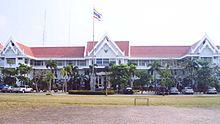
Provincial hall (Sala khlang) of Surat Thani province, Thailand. Photo by User:Ahoerstemeier taken on January 27 2006.


