Sukkur
| Sukkur | |
|---|---|
 | |
| Overblik | |
| Land | |
| Grundlagt | 1862 |
| Telefonkode | 071 |
| Demografi | |
| Indbyggere | 499.900 (2017) |
| - Areal | 5.165 km² |
| - Befolkningstæthed | 96,8 pr. km² |
| Andet | |
| Højde m.o.h. | 67 m |
| Hjemmeside | www.lgdsindh.com.pk/sukkur.htm |

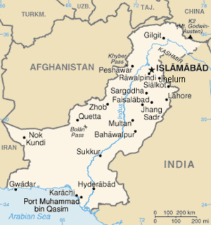
Sukkur er en by i det syd-centrale Pakistan med 499.900(2017) indbyggere. Byen ligger i distriktet Sindh, ved bredden af Indus-floden. Området omkring Multan er et af de mest benyttede landbrugsområder i Pakistan.

Eksterne henvisninger
Koordinater: 27°41′N 68°52′Ø / 27.683°N 68.867°Ø
| Spire Denne artikel om Pakistans geografi er en spire som bør udbygges. Du er velkommen til at hjælpe Wikipedia ved at udvide den. |
|
Medier brugt på denne side
Forfatter/Opretter: derivative work: Fry1989 (talk) 06:12, 23 February 2011 (UTC), Licens: CC BY-SA 3.0
Flag map of Pakistan
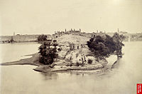
This print was taken by an unknown photographer in the 1860s. It shows a general view of the city of en:Sukkur situated in upper Sind province in modern-day Pakistan. The city lies on the west bank of the River Indus as it runs through the Thar Desert. In 1888 Landsdowne Bridge was constructed over the river providing a railway link between Sukkur and the rest of the sub-continent. Sukkur lies in the heart of the Indus Valley, the location of the earliest civilisations in South Asia, with Harappa and Mohenjo Daro both sites local to the area. Sukkur itself has remains dating to the late stone age era. Source: British Library


