Storhertugdømmet Toscana
Storhertugdømmet Toscana Granducato di Toscana | |||||||||||||||
|---|---|---|---|---|---|---|---|---|---|---|---|---|---|---|---|
| 1569–1859 | |||||||||||||||
Flag | |||||||||||||||
Nationalmelodi: "La Leopolda" | |||||||||||||||
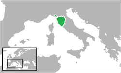
 Storhertugdømmet Toscana i 1700. | |||||||||||||||
| Hovedstad | Firenze | ||||||||||||||
| Sprog | Italiensk | ||||||||||||||
| Religion | Romersk-katolsk | ||||||||||||||
| Regeringsform | Storhertugdømme | ||||||||||||||
| Storhertug | |||||||||||||||
• 1569-1574 | Cosimo 1. de' Medici | ||||||||||||||
• 1824-1859 | Leopold 2. af Toscana | ||||||||||||||
| Historie | |||||||||||||||
• Etableret | 27. august 1569 | ||||||||||||||
• Aranjuez-traktaten | 21. marts 1801 | ||||||||||||||
| 9. juni 1815 | |||||||||||||||
• Stiftelse af Mellemitaliens Forenede Provinser | 8. december 1859 | ||||||||||||||
• Risorgimento | 17. marts 1861 | ||||||||||||||
| Indbyggertal og befolkning | |||||||||||||||
• Anslået 1801 | 1.096.641 | ||||||||||||||
| Valuta | Toscana lira | ||||||||||||||
| |||||||||||||||
Storhertugdømmet Toscana (italiensk: Granducato di Toscana) var et land i det nordlige Italien. Det eksisterede i to perioder. Oprettet i 1569, da det tidligere Hertugdømmet Firenze blev ophøjet til storhertugdømme af Pave Pius 5. Efter Napoleons sejre i det nordlige Italien, blev landet, ifølge Aranjuez-traktaten, omdannet til Kongeriget Etrurien i 1801. Da Napoleon var ude af billedet, genoprettedes landet i 1815 efter Wienerkongressen. I 1847 annekteredes nabolandet Lucca. Det fik sin afslutning efter en revolution i 1859.
Referencer
 Der er for få eller ingen kildehenvisninger i denne artikel, hvilket er et problem. Du kan hjælpe ved at angive troværdige kilder til de påstande, som fremføres i artiklen.
| ||||||||||||||||||||||||||||
|
Koordinater: 43°N 11°Ø / 43°N 11°Ø
Medier brugt på denne side
Forfatter/Opretter: F l a n k e r, Licens: CC BY-SA 2.5
Flag of the Kingdom of Sardinia (1851-1861) and of the Kingdom of Italy (1861-1946). Use: Civil flag and ensign. In a governmental or a military context, the crowned version (see Crowned version) was always used (as State flag and naval ensign).
Forfatter/Opretter: Gabagool, Licens: CC BY 3.0
Locator map showing the Grand Duchy of Tuscany in the year 1700. (Territory was largely the same through its entire existence)
(Partially based on Euratlas map of Europe - 1800.)
Bandiera del granducato di Toscana (1562-1737) con lo stemma dei Medici.
Map of unification of Italy, 1815-70. Shown territories include: Kingdom of Sardinia, Kingdom of the Two Sicilies, Kingdom of Lombardy-Venetia, Duchy of Parma and Piacenza, Duchy of Modena and Reggio, Grand Duchy of Tuscany, Papal States
Forfatter/Opretter: myself, Licens: CC BY-SA 3.0
Medici Flag of Tuscany in the late 1500s.
Forfatter/Opretter: F l a n k e r, Licens: CC BY-SA 2.5
Flag of the Kingdom of Sardinia (1851-1861) and of the Kingdom of Italy (1861-1946). Use: Civil flag and ensign. In a governmental or a military context, the crowned version (see Crowned version) was always used (as State flag and naval ensign).
Forfatter/Opretter: Oren neu dag (talk), Licens: CC BY-SA 3.0
Det er let at give dette billede en kant
Det er let at give dette billede en kant


