Store sandhav
| Store sandhav بحر الرمال الأعظم | |
|---|---|
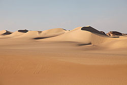
(c) Roland Unger, CC BY-SA 3.0 Sandklitterne i det store sandhav nær Siwa i Egypten | |
| Overblik | |
| Land | |
| Areal | 72.000 |
| Højde m.o.h. | 100 |


Det Store sandhav er et omkring 72.000 km² stort ørkenområde i Nordafrika, som strækker sig fra det vestlige Egypten til det østlige Libyen. Trods navnet er det kun 7% af det store sandhav, der er dækket af sandklitter.[1]
Geografi
Det store sandhav er omkring 650 km langt fra nord til syd og omkring 300 km bredt fra øst til vest. På satellitbilleder har denne ørken et mønster af lange sandbakker, som løber nogenlunde nord-syd, men trods den tilsyneladende ensartethed har sandhavet to store områder med forskellige typer af megaklitter. Sammen med Calanshio Sandhavet og Ribiana Sandhavet i Libyen, dækker sandklitterne i det store sandhav omkring 25% af den libyske ørken.[2]
Siwa er en oase i Egypten omkring 50 km øst for den libyske grænse i den østlige del af det store sandhav.
Selv om området var velkendt for Tuareger og købmænd, som rejste med karavaner gennem Sahara var Friedrich Gerhard Rohlfs den første europæer, som beskrev det store sandhav. Han begyndte sin Saharaekspedition i 1865, og kaldte det store område med sandklitter for Große Sandmeer, men det var først i 1924 med kortene tegnet af Ahmed Hassanein at det fulde omfang af det store sandhav blev kendt af europæere.[3]
Henvisninger
- ^ Ernst-Michael Steffan, Untersuchungen zur Morphologie und Genese der aeolischen Akkumulationsformen der Ostsahara mit Hilfe der Fernerkundung. Berliner geowissenschaftliche Abhandlungen. 1983
- ^ Besler, Helga (2008) The Great Sand Sea in Egypt: Formation, Dynamics and Environmental Change: A Sediment-Analytical Approach Elsevier, Amsterdam, page 1 - 3, ISBN 978-0-444-52941-1
- ^ "The Great Sand Sea - Rough Guides". Arkiveret fra originalen 3. februar 2016. Hentet 28. januar 2016.
Eksterne kilder
- Egypt Travel - The Great Sand Sea Arkiveret 3. marts 2016 hos Wayback Machine
- Desert Geomorphology
Koordinater: 29°30′N 21°45′Ø / 29.500°N 21.750°Ø
Medier brugt på denne side
(c) Roland Unger, CC BY-SA 3.0
Silica Glass Area, Egyptian Sand Sea, Western Desert, Egypt
Forfatter/Opretter: NASA's Earth Observatory, Licens: CC BY 2.0
To download the full resolution and other files go to: earthobservatory.nasa.gov/IOTD/view.php?id=78151&src=...
In southwestern Egypt, deep in the Sahara Desert, the wind dominates the shape of the landscape, as it has done for the past several thousand years. Winds blowing from the north have fashioned sands into large dunes, aligned parallel with these winds.
The so-called linear dunes—shown here in the Great Sand Sea of southwest Egypt—are easily spotted from space, and local maps show that they rise 20 to 30 meters above the surrounding plains. The distance between dunes is interestingly regular, at 1.5 to 2.5 kilometers, suggesting some equilibrium exists between the wind strength and the sand supply. It is possible that the linear dunes are a reflection of earlier times, when winds were stronger or sand more plentiful.
The dark rock outcrops at image lower left stand above the surface by as much as 150 meters. North winds have been deflected around this high zone, and smaller secondary linear dunes appear along the left side of the image, aligned with local winds that become ever more northeasterly as they approach the outcrops. A dune-free zone on the protected downwind (south-southeast) side of the outcrop gives a sense of the sand movement.
At first glance, the large linear dunes appear to be the major landform in the image; however, a complex pattern of even smaller dunes can be seen on top of the largest dunes (inset). It is not uncommon to observe multiple dune forms in large sand seas, as in the Marzuq Sand Sea, the Ar Rub' Al Khali, and the Tenere Desert.
The sand in many dune fields usually derives from some larger river not very distant upwind; often it comes from a dry river bed that gets exposed to wind during dry seasons, or from a low-flow river that changed due to a more arid regional climate. Inland dune fields thus lie downwind of the source river. West of the dunes shown in this photograph, a large, unnamed river once flowed to the Mediterranean Sea and dumped its sand load 300 kilometers northwest of the area shown. It is likely that this river—evidence of which is now almost completely obliterated—was the source of the sand in the linear dunes.
Astronaut photograph ISS031-E-30783 was acquired on May 11, 2012, with a Nikon D2Xs digital camera using a 180 mm lens, and is provided by the ISS Crew Earth Observations experiment and Image Science & Analysis Laboratory, Johnson Space Center. The image was taken by the Expedition 31 crew. It has been cropped and enhanced to improve contrast, and lens artifacts have been removed. The International Space Station Program supports the laboratory as part of the ISS National Lab to help astronauts take pictures of Earth that will be of the greatest value to scientists and the public, and to make those images freely available on the Internet. Additional images taken by astronauts and cosmonauts can be viewed at the NASA/JSC Gateway to Astronaut Photography of Earth. Caption by M. Justin Wilkinson, Jacobs/ESCG at NASA-JSC.
The Earth Observatory's mission is to share with the public the images, stories, and discoveries about climate and the environment that emerge from NASA research, including its satellite missions, in-the-field research, and climate models.
Like us on Facebook
Follow us on Twitter
Add us to your circles on Google+Forfatter/Opretter: T L Miles, Licens: CC BY-SA 3.0
Map showing major Dune seas (ergs) and Mountain ranges of the Sahara. Red dashed line shows approximate limit of the Sahara. National borders in grey. Dune seas in yellow. Derived from Blank map Image:Africa_topography_map_with_borders.png. Data taken from http://www.sahara-overland.com image of Michlein Map and Geology.com's Sahara Desert Map.


