Staffordshire

Staffordshire er et amt (county) i den engelske region West Midlands. Staffordshire grænser op til Cheshire, Derbyshire, Leicestershire, Warwickshire, West Midlands, Worcestershire, og Shropshire. Den største by i Staffordshire er Stoke-on-Trent.

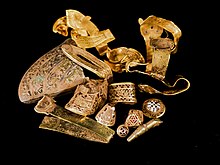
I 2009 fandt en amatørarkæolog en stor skat på en mark nær Lichfield i det sydlige Staffordshire. Skatten bestod af angelsaksiske guld- og sølvgenstande[1]
Byer
| Rang | Navn | Distrikt | Indbyggertal[2][3][4] | |
|---|---|---|---|---|
| 2001 | 2011 | |||
| 1 | Stoke-on-Trent | Stoke-on-Trent | 240,636 | 249,008 |
| 2 | Tamworth | Tamworth | 75,800 | 76,813 |
| 3 | Newcastle-under-Lyme | Newcastle-under-Lyme | 73,944 | 75,082 |
| 4 | Burton-upon-Trent | East Staffordshire | 64,449 | 72,299 |
| 5 | Stafford | Stafford | 55,700 | 68,472 |
| 6 | Lichfield | Lichfield | 30,050 | 32,877 |
| 7 | Cannock | Cannock Chase | 28,435 | 29,018 |
| 8 | Burntwood | Lichfield | 25,674 | 28,553 |
| 9 | Kidsgrove | Newcastle-under-Lyme | 24,112 | 26,293 |
| 10 | Rugeley | Cannock Chase | 22,724 | 24,033 |
| 11 | Leek | Staffordshire Moorlands | 18,678 | 19,624 |
| 12 | Biddulph | Staffordshire Moorlands | 17,241 | 17,669 |
| 13 | Hednesford | Cannock Chase | 16,961 | 17,343 |
| 14 | Stone | Stafford | 14,258 | 16,385 |
| 15 | Wombourne | South Staffordshire | 13,691 | 13,511 |
| 16 | Uttoxeter | East Staffordshire | 13,309 | 13,089 |
| 17 | Heath Hayes and Wimblebury | Cannock Chase | 12,176 | 14,085 |
| 18 | Cheadle | Staffordshire Moorlands | 12,158 | 11,404 |
| 19 | Great Wyrley | South Staffordshire | 11,236 | 11,060 |
| 20 | Perton | South Staffordshire | 11,118 | 10,686 |
| 21 | Penkridge | South Staffordshire | 7,000 | 7,791 |
| 22 | Codsall | South Staffordshire | 7,496 | 7,582 |
| 23 | Norton Canes | Cannock Chase | 6.394 | 7,479 |
| 24 | Eccleshall | Stafford | 6,312 | 6,657 |
| 25 | Bilbrook | South Staffordshire | 4,569 | 4,913 |
| 26 | Kinver | South Staffordshire | 4,607 | 4,723 |
| 27 | Armitage | Lichfield | 4,675 | 4,650 |
Seværdigheder
- Alton Towers

- Ancient High House


- Apedale Community Country Park


- Biddulph Grange

- Blithfield Hall

- Blithfield Reservoir

- Brindley Water Mill

- Broad Eye Windmill
- Cannock Chase

- Chasewater Railway

- Cheddleton Flint Mill

- Churnet Valley Railway

- Croxden Abbey


- Dovedale

- Downs Banks

- Drayton Manor Theme Park

- Eccleshall Castle

- Erasmus Darwin House


- Ford Green Hall

- Foxfield Steam Railway

- Gladstone Pottery Museum

- Hanley Park

- Heart of England Way

- Moseley Railway Trust (Apedale)


- Ilam Park

- Izaak Walton's Cottage


- Manifold Way following the route of the former Leek and Manifold Valley Light Railway
- National Brewery Centre

- Lichfield Cathedral

- Madeley Old Hall

- Monkey Forest at Trentham Gardens

- Moseley Old Hall

- Mow Cop Castle

- Middleport Pottery
- National Memorial Arboretum
- Peak District National Park

- Potteries Museum & Art Gallery

- Pennine Way

- RSPB Coombes Valley

- Rudyard Lake Steam Railway

- Sandon Hall

- Shugborough Estate

- Stafford Parish Church

- Stafford Castle

- Staffordshire Regiment Museum

- Staffordshire Way

- Stoke Minster

- The Roaches

- Tamworth Castle

- Trentham Gardens

- Tutbury Castle

- Victoria Park, Stafford

- Wall Roman Site


- Wedgwood Museum

- Weston Park

- Whitmore Hall

Referencer
- ^ Hobbyarkæolog bag Englands største guldfund Arkiveret 12. januar 2012 hos Wayback Machine – kpn.dk
- ^ "Neighbourhood Statistics". www.neighbourhood.statistics.gov.uk. 2008-04-14. Hentet 1. december 2016.
- ^ "Staffordshire (County, West Midlands, United Kingdom) - Population Statistics and Location in Maps and Charts". www.citypopulation.de. Hentet 1. december 2016.
- ^ "Stoke-on-Trent (Unitary District, West Midlands, United Kingdom) - Population Statistics and Location in Maps and Charts". www.citypopulation.de. Hentet 1. december 2016.
Eksterne henvisninger
Medier brugt på denne side
Icon for use on UK lists of places of interest.
(c) WebHamster at engelsk Wikipedia, CC BY-SA 3.0
National Trust of the U.K. logo — with acorn icon.
- Used as Places-of-Interest map locator symbol.
- Credits
- Self made image in SVG format of an icon remarkably similar to an acorn
geometric design in SVG format very similar to that used by the English Heritage as an icon to represent items of interest.
Castle icon in SVG vector format
(c) Williams119 at the English Wikipedia, CC BY-SA 3.0
created for use on UK places of interest
Forfatter/Opretter: David Rowan, Birmingham Museum and Art Gallery, Licens: CC BY 2.0
rise up, o Lord, and may thy enemies be scattered and those who hate thee be driven from thy face
Theme Park icon (UK)


