St. Moritz
| Sankt Moritz | |||
|---|---|---|---|
| |||
 | |||
| Overblik | |||
| Land | |||
| Kanton | Graubünden | ||
| Postnr. | 7500 | ||
| Telefonkode | 081 | ||
| Nummerpladebogstav(er) | GR | ||
| Demografi | |||
| Indbyggere | 4.994 (2017)[1] | ||
| - Areal | 28,7 km² | ||
| - Befolkningstæthed | 174 pr. km² | ||
| Andet | |||
| Tidszone | UTC+1 (normaltid) UTC+2 (sommertid) | ||
| Højde m.o.h. | 1.822 m | ||
| Hjemmeside | www.stmoritz.ch | ||
| Oversigtskort | |||
 Sankt Moritz | |||

Sankt Moritz (italiensk San Maurizio, rætoromansk San Murezzan, fransk Saint-Moritz) er en alpelandsby med 4.994 (2017)[1] indbyggere i den schweiziske kanton Graubünden. Byen er berømt som kursted[2] og vintersportssted.[3]
St. Moritz arrangerede de olympiske vinterlege i 1928[4]og 1948.[5] St. Moritz begyndte som vintersportssted allerede i 1864.[3]
Galleri
 (c) Patrick Nouhailler's…, CC BY-SA 3.0
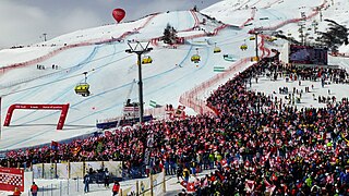
VM i alpint skiløb
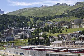
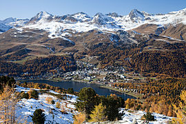
Sommer i St. Moritz

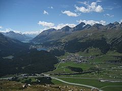
Vinter i St. Moritz

St. Moritz bymidte
Kildehenvisninger
- ^ a b Bilanz der ständigen Wohnbevölkerung nach institutionellen Gliederungen, Staatsangehörigkeit (Kategorie), Geschlecht und demographischen Komponenten, Federal Statistical Office, hentet 12. januar 2019 (fra Wikidata).
- ^ "Birgit Stöber og Henning Strand i denstoredanske.dk, Sankt_Moritz". Hentet 19. maj 2019.
- ^ a b "engadin.stmoritz.ch, stmoritz". Hentet 19. maj 2019.
- ^ "olympic.org, t-moritz-1928". Hentet 18. maj 2019.
- ^ "britannica.com, St-Moritz-1948-Olympic-Winter-Games". Hentet 18. maj 2019.
Eksterne henvisninger
|
| Spire Denne artikel om Schweiz' geografi er en spire som bør udbygges. Du er velkommen til at hjælpe Wikipedia ved at udvide den. |
Medier brugt på denne side

Switzerland location map.svg
Forfatter/Opretter: NordNordWest, Licens: CC BY-SA 3.0
Location map of Switzerland
Forfatter/Opretter: NordNordWest, Licens: CC BY-SA 3.0
Location map of Switzerland

Olympic flag.svg
Olympic Movement flag
Olympic Movement flag
Proportions 2:3, created 1913, adopted 1914, first used 1920.
- Colors as per http://fairspielen.de/wp-content/uploads/2015/09/Annexe-3-Olympism_and_the_Olympic_Symbol_-_Principles_and_Usages_Guide-1.pdf
- blue: PMS 3005C
- yellow: PMS 137C
- black: PMS 426C
- green: PMS 355C
- red: PMS 192C
- Dimensions of the rings taken from http://fairspielen.de/wp-content/uploads/2015/09/Annexe-3-Olympism_and_the_Olympic_Symbol_-_Principles_and_Usages_Guide-1.pdf

Olympic rings.svg
Olympic Rings without "rims" (gaps between the rings), As used, eg. in the logos of the 2008 and 2016 Olympics. The colour scheme applied here was specified in 2023 guidelines.
Olympic Rings without "rims" (gaps between the rings), As used, eg. in the logos of the 2008 and 2016 Olympics. The colour scheme applied here was specified in 2023 guidelines.
Olympic rings without rims.svg
Olympic Rings without "rims" (gaps between the rings), As used, eg. in the logos of the 2008 and 2016 Olympics. The colour scheme applied here was specified in 2023 guidelines.
Olympic Rings without "rims" (gaps between the rings), As used, eg. in the logos of the 2008 and 2016 Olympics. The colour scheme applied here was specified in 2023 guidelines.

SkiWM Moritz 2017.jpg
Forfatter/Opretter: Cutkiller2018, Licens: CC BY-SA 4.0
Zielhang der Ski WM 2017 in St. Moritz
Forfatter/Opretter: Cutkiller2018, Licens: CC BY-SA 4.0
Zielhang der Ski WM 2017 in St. Moritz

St Moritz Muottas.jpg
Forfatter/Opretter: Murdockcrc, Licens: CC BY 3.0
View of St. Moritz and its lake, as seen from Muottas da Schlarigna, Grisons. Switzerland. On the left is Piz Nair (3056 m), to the right is Piz Saluver (3159 m)
Forfatter/Opretter: Murdockcrc, Licens: CC BY 3.0
View of St. Moritz and its lake, as seen from Muottas da Schlarigna, Grisons. Switzerland. On the left is Piz Nair (3056 m), to the right is Piz Saluver (3159 m)

Švýcarsko-pahýl.svg
Forfatter/Opretter: Дмитрий-5-Аверин, Licens: CC BY-SA 3.0
Flag-map of Switzerland
Forfatter/Opretter: Дмитрий-5-Аверин, Licens: CC BY-SA 3.0
Flag-map of Switzerland

Muragl LCD-edit.jpg
Forfatter/Opretter:
View of the High Engadin valley from Muragl, canton Grisons, Switzerland.
Forfatter/Opretter:
- Muragl_LCD.jpg: Murdockcrc
- derivative work: Purpy Pupple (talk)
View of the High Engadin valley from Muragl, canton Grisons, Switzerland.
.jpg)

St-Moritz-Celerina.jpg
Forfatter/Opretter: Grischun, Licens: CC BY 2.5
Blick auf Oberengadiner Seenplatte mit St. Moritz und Celerina
Forfatter/Opretter: Grischun, Licens: CC BY 2.5
Blick auf Oberengadiner Seenplatte mit St. Moritz und Celerina
.jpg)
St. Moritz - Heart of the village (15452091673).jpg
Forfatter/Opretter: Kecko from Switzerland (Rheintal SG), Licens: CC BY 2.0
A heavily trafficked roundabout at the edge of the reduced-traffic area. Seen from the Via Maistra. Switzerland, Dec 19, 2014. (8/9)
Forfatter/Opretter: Kecko from Switzerland (Rheintal SG), Licens: CC BY 2.0
A heavily trafficked roundabout at the edge of the reduced-traffic area. Seen from the Via Maistra. Switzerland, Dec 19, 2014. (8/9)