Southampton Island
| Southampton Island | |
|---|---|
 | |
| Geografi | |
 Southampton Island | |
| Sted | canadiske arktiske øhav |
| Koordinater | 64°30′N 084°30′V / 64.500°N 84.500°VKoordinater: 64°30′N 084°30′V / 64.500°N 84.500°V |
| Areal | 41.214 km² |
| Højeste punkt | Mathiassen Mountain (625 m) |
| Administration | |
| Land | |
| Territorie | Nunavut |
| Største by | Coral Harbour (834[1] indb.) |
| Folketal | (2011) |
Southampton Island (Inuktitut: Shugliaq) [2] er en stor ø ved vestsiden af mundingen til Hudsonbugten ved Foxe Basin. Den er en af de større øer i det canadiske arktiske øhav. Southampton Island, er en del af Kivalliq-regionen i Nunavut, Canada. Øens areal er angivet til 41.214 km²[3]. Det er den 34. største ø i verden og Canadas niende største ø. Den eneste bebyggelse på Southampton Island er Coral Harbour kaldet Salliq i Inuktitut, der i 2011 havde en befolkning på 834 mennesker.
Southampton Island er et af de få canadiske områder og det eneste område i Nunavut, der ikke bruger sommertid.
Historie
Historisk set er Southampton Island kendt for sine nu uddøde indbyggere, Sadlermiut (moderne Inuktitut Sallirmiut "Indbyggere i Salliq "), som var den sidste rest af Tuniit eller Dorset-kulturen. Tuniit, en præ-inuit kultur, blev officielt uddød etnisk og kulturelt i 1902-03 [4] da infektionssygdom dræbte hele Sallirmiut i løbet af få uger.
Øens første registrerede besøg af europæere var i 1613 da den walisiske opdagelsesrejsende Thomas Button besøgte øen. [5]

I begyndelsen af det 20. århundrede blev øen genbefolket af Aivilingmiut fra Repulse Bay og terskelfjorden Chesterfield, påvirket af hvalfangeren Kaptajn George Comer og andre. Andre ankom fra Baffin Island 25 år senere. John Ell, der som et lille barn rejste med sin mor Shoofly på Comers skonnert, blev til senere den mest berømte af Southampton Islands genbosatte befolkning.[6]
Det arkæologiske sted Native Point ved mundingen af Native Bay er det største Sadlermiutsted på øen. [7]
Geografi
Øen er adskilt fra Melville-halvøen af Frozen Strait.[8] Andre farvande omkring øen inkluderer Roes Welcome Sound mod vest, Bay of Gods Mercy i sydvest, Fisher Strait i syd, Evans Strait i sydøst og Foxe Channel i øst.
Bell-halvøen ligger på den sydøstlige del af øen.[9] Mathiassen Mountain, der ligger i Porsild-bjergene, er øens højeste top.
Fauna
East Bay Migratory Bird Sanctuary og Harry Gibbons Migratory Bird Sanctuary ligger på øen og er vigtige ynglesteder for den snegås (Anser caerulescens caerulescens). Øen er også stedet for to vigtige fugleområder (IBA'er), Boasflodens vådområder i sydvest og East Bay/Native Bay i sydøst. Begge er vært for store sommerkolonier af snegæs, der tilsammen udgør over 10% af verdens bestand af disse, hvor Boas River-stedet alene er vært for over 500.000 individer, der yngler der. Mindre, men også vigtig, er kolonierne af knortegæs (Branta bernicla) og talrige andre polarfuglearter der.[10][11] Southampton Island er et af de to vigtigste sommeropholdsted der er kendt for grønlandshvaler i Hudson Bay.[12][13][14]
Galleri
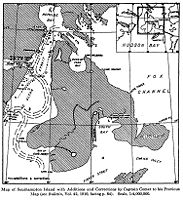
Kaptajn kaptajn George Comers kort over Southampton i 1913.
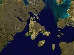
Satellitfoto montage af Southampton Island

Kilder og henvisninger
- ^ "Census Profile". 2.statcan.gc.ca. Hentet 2016-03-22.
- ^ Issenman, Betty.
- ^ Statistics Canada Arkiveret 2004-08-12 hos Wayback Machine
- ^ Briggs, Jean L.; J. Garth Taylor. "The Canadian Encyclopedia: Sadlermiut Inuit". Historica Foundation of Canada. Arkiveret fra originalen 2008-10-20. Hentet 2008-03-21.
- ^ Christy, Miller (1894). The voyages of Captain Luke Foxe of Hull, and Captain Thomas James of Bristol, in search of a northwest passage, in 1631-32; with narratives of the earlier northwest voyages of Frobisher, Davis, Weymouth, Hall, Knight, Hudson, Button, Gibbons, Bylot, Baffin, Hawkridge, and others. London: Hakluyt Society.
related:STANFORD36105004846502.
- ^ Rowley, Graham (1996-06-11). Cold comfort: my love affair with the Arctic. Montreal: McGill-Queen's University Press. s. 38. ISBN 0-7735-1393-0. Hentet 2008-04-04.
- ^ "History". edu.nu.ca. Hentet 2009-05-05.
- ^ "Frozen Strait". The Columbia Gazetteer of North America. 2000. Arkiveret fra originalen 2005-05-22. Hentet 2008-04-07.
- ^ "Mathiasen Mountain Nunavut". bivouac.com. Hentet 2008-10-14.
- ^ "Boas River and associated wetlands (NU022)". Important Bird Areas. IBA Canada. Hentet 2016-12-11.
- ^ "East Bay/Native Bay (NU023)". Important Bird Areas. IBA Canada. Hentet 2016-12-11.
- ^ COSEWIC Assessment and Update Status Report on the Bowhead Whale Balaena mysticetus (PDF). COSEWIC. 2005. ISBN 0-662-40573-0.
- ^ "Coral Harbour - Land and Wildlife". www.coralharbour.ca. Arkiveret fra originalen 18. april 2018. Hentet 19. april 2018.
- ^ http://www.nwmb.com/en/public-hearings/2008/mar-06-2008-level-of-tah-for-bowhead-whales/552-tab16-arctic-2000/file
Yderligere læsning
- Bird, J. Brian. Southampton Island. Ottawa: E. Cloutier, 1953.
- Brack, D. M. Southampton Island Area Economic Survey With Notes on Repulse Bay and Wager Bay. Ottawa: Area & Community Planning Section, Industrial Division, Dept. of Northern Affairs and National Resources, 1962.
- Mathiassen, Therkel. Contributions to the Physiography of Southampton Island. Copenhagen: Gyldendalske Boghandel, 1931.
- Parker, G. R. An Investigation of Caribou Range on Southampton Island, Northwest Territories. Ottawa: Information Canada, 1975.
- Pickavance, J. R. 2006. "The Spiders of East Bay, Southampton Island, Nunavut, Canada". Arctic. 59, no. 3: 276–282.
- Popham RE. 1953. "A Comparative Analysis of the Digital Patterns of Eskimo from Southampton Island". American Journal of Physical Anthropology. 11, no. 2: 203–13.
- Popham RE, and WD Bell. 1951. "Eskimo crania from Southampton Island". Revue Canadienne De Biologie / ̐ưedit̐ưee Par L'Universit̐ưe De Montr̐ưeal. 10, no. 5: 435–42.
- Sutton, George Miksch, and John Bonner Semple. The Exploration of Southampton Island. Pittsburgh: Carnegie Institute, 1932.
- Sutton, George Miksch. The Birds of Southampton Island. Pittsburgh: Carnegie Institute, 1932.
- VanStone, James W. The Economy and Population Shifts of the Eskimos of Southampton Island. Ottawa: Northern Co-ordination and Research Centre, Dept. of Northern Affairs and National Resources, 1959.
Medier brugt på denne side
.svg)
Flag of Canada introduced in 1965, using Pantone colors. This design replaced the Canadian Red Ensign design.

A map of Southampton Island, Hudson Bay, Canada
Forfatter/Opretter: Mike Beauregard from Nunavut, Canada, Licens: CC BY 2.0
Some of the raised beaches of Southampton Island, Nunavut from above where this scrambled landform extends a long ways inland from present-day coastline.
Much of the Arctic is still !! rebounding from the removal of the last continental ice-sheet. Throughout the past 10,000 years, the local tide was just enough to rework (but not erase) each and every emergent strand line.
Today's aerial skein of snow-enhanced strand lines courtesy of the spring thaw. Taken thru the window on a northern airline.Forfatter/Opretter: Yug, Licens: CC BY-SA 3.0
cropped version of Carte administrative du Canada.svg for map location.
(c) Kelisi fra en.wikipedia.org, CC BY-SA 3.0
A closeup map of Southampton Island, Hudson Bay, Canada