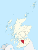
South Lanarkshire

South Lanarkshire (skotsk: Sooth Lanrikshire; skotsk gælisk: Siorrachd Lannraig a Deas er en af de 32 kommuner eller enhedslig myndigheder council areas i Skotland. Det grænser op til City of Glasgow og indeholder nogle af Greater Glasgows forstæder, samt mange landsbyer. Det grænser desuden op til Dumfries and Galloway, East Ayrshire, East Renfrewshire, North Lanarkshire, Scottish Borders og West Lothian. Det inkluderer størstedelen af det historiske county Lanarkshire.
Byer og landsbyer
| By | Indbyggertal[1] |
|---|---|
| Blantyre | 16.800 |
| Cambuslang | 30.790 |
| Carluke | 13.810 |
| East Kilbride | 75.310 |
| Hamilton | 54.480 |
| Lanark | 8.880 |
| Larkhall | 15.030 |
| Rutherglen | 30.950 |
| Strathaven | 8.090 |
Seværdigheder
- Bothwell Castle
- Calderglen Country Park, East Kilbride
- Chatelherault Country Park, Hamilton, inklusive Cadzow Castle
- Clyde Valley
- Craignethan Castle
- David Livingstone Centre, Blantyre
- Dollan Aqua Centre, East Kilbride
- Falls of Clyde
- Hamilton Mausoleum
- James Hamilton Heritage Park, East Kilbride
- John Hastie Museum, Strathaven
- Lanark Loch
- Little Sparta, near Dunsyre near Lanark
- Low Parks Museum, Hamilton
- National Museum of Rural Life
- New Lanark, på UNESCO's Verdensarvsliste
- Rutherglen Town Hall og middelalder kirketårn
- Stederne for slaget ved Drumclog og slaget ved Bothwell Bridge
- Strathaven Castle
- Wilsontown Ironworks
Referencer
- ^ Mid-2020 Population Estimates for Settlements and Localities in Scotland Arkiveret 12. december 2023 hos Wayback Machine. nrscotland.gov.uk. Hentet 9/2-2023
Eksterne henvisninger
| Spire |
Medier brugt på denne side
Forfatter/Opretter:
- Scotland_location_map.svg: NordNordWest
- Flag_of_Scotland.svg: Kbolino
- derivative work: Fry1989 (talk) 21:12, 25 January 2011 (UTC)
Flag map of Scotland
Forfatter/Opretter: TUBS
Location of council area xy (see filename) in Scotland.

