South Downs
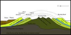
South Downs er et lavlandsområde med kalkgrund i det sydlige England. Det går parallelt med North Downs, og de to områder bestod engang en kuppelformet kalkklippe. De skilles nu fra hinanden af Weald, et område hvor kalkstensgrunden er blevet slidt ned af erosion.
Området strækker sig omkring 100 km gennem East Sussex, West Sussex og Hampshire. Vejen South Downs Way går langs området.
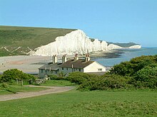
De mest kendte klipper er Beachy Head ved Eastbourne og Seven Sisters mellem Eastbourne og Seaford. Det højeste punkt er Butser Hill, som når 270 moh. og er en af Englands marilyns.
South Downs er på listen over Area of Outstanding Natural Beauty. Desuden er området sammen med store dele af Weald South Downs National Park.
Byer og landsbyer

- Arundel
- Brighton
- Eastbourne
- Hove
- Lewes
- Midhurst
- Portslade
- Shoreham-by-Sea
- Washington
|
Koordinater: 50°55′N 0°30′V / 50.92°N 0.5°V
Medier brugt på denne side
Forfatter/Opretter: The original uploader was StephenDawson at engelsk Wikipedia., Licens: CC BY-SA 2.0
Seven Sisters chalk cliffs in East Sussex. The number seven refers to the cliff peaks, which are individually named: from the west they are Haven Brow, Short Brow, Rough Brow, Brass Point, Flagstaff Point (continuing into Flagstaff Brow), Baily's Hill, and Went Hill Brow. Beyond, on the top of the next hill, is Belle Tout lighthouse. The dips between each Sister are also named: Short Bottom, Limekiln Bottom, Rough Bottom, Gap Bottom, Flagstaff Bottom, and Michel Dean.
The South Downs Way runs along the edge of the cliffs, taking a very undulating course.
Photograph by Stephen Dawson, 26 May 2003.
commons:category:East SussexForfatter/Opretter: ClemRutter, Licens: CC BY-SA 3.0
A simplified geological diagram of the Wealden Dome as relating to Kent.


