Sjebekino
| Sjebekino Шебекино | |||||
|---|---|---|---|---|---|
| |||||
 | |||||
| Overblik | |||||
| Land | |||||
| Føderalt distrikt | Centrale | ||||
| Økonomisk region | Centrale Sortjords | ||||
| Oblast | Belgorod | ||||
| Grundlagt | 1713 | ||||
| Postnr. | 309290 | ||||
| Telefonkode | 47248 | ||||
| UN/LOCODE | RUB2L | ||||
| Demografi | |||||
| Indbyggere | 39.680 (2021) | ||||
| - Areal | 40,0 km² | ||||
| - Befolkningstæthed | 992 pr. km² | ||||
| Andet | |||||
| Tidszone | UTC+3 | ||||
| Højde m.o.h. | 110 m | ||||
| Hjemmeside | www.admshebekino.ru | ||||
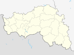
| Oversigtskort | |||||
| Belgorod oblasts beliggenhed i Rusland | |||||
(c) Karte: NordNordWest, Lizenz: Creative Commons by-sa-3.0 de Sjebekino | |||||
Sjebekino (russisk: Шебе́кино) er en by i Belgorod oblast i den europæiske del af Den Russiske Føderation.
Sjebekino ligger ved floden Nezjegol, en biflod til floden Donets. Byen blev grundlagt i 1713 ![]() . Den har et areal på 40 km2 og et indbyggertal på 39.680 (2021) indbyggere.
. Den har et areal på 40 km2 og et indbyggertal på 39.680 (2021) indbyggere.
Referencer
Eksterne henvisninger
| Spire |
Medier brugt på denne side
Flag-map of Russia
Forfatter/Opretter: TUBS
Location of XY (see filename) in Russia
Forfatter/Opretter: Лобачев Владимир, Licens: CC0
Coats of arms of Shebekino
Forfatter/Opretter: Ilga Gondareva, Licens: CC BY 3.0
This is a photo of a cultural heritage object in Russia, number:
New Flag of Belgorod Oblast
Forfatter/Opretter: Лобачев Владимир, Licens: CC0
Flag of Shebekino and Shebekinsky district (Belgorod region). Approved by the decision of the Council of Deputies of the Shebekinsky district and the city of Shebekino No. 1 dated 10.06.2003
Позиционная карта Белгородской области
Равноугольная проекция, растяжение — 155%. Координаты краёв:
- север — 51.6° С
- юг — 49.6° С
- восток — 39.4° В
- запад — 35.2° В
(c) Karte: NordNordWest, Lizenz: Creative Commons by-sa-3.0 de
Location map of European Russia.
- Projection: Lambert azimuthal equal-area projection.
- Area of interest:
- N: 75.0° N
- S: 40.0° N
- W: 25.0° E
- E: 60.0° E
- Projection center:
- NS: 57.5° N
- WE: 42.5° E
- GMT projection: -JA42.5/57.5/20c
- GMT region: -R25.450860698632475/38.37411418933942/86.79037939442836/70.79910933370674r
- GMT region for grdcut: -R-2.0/38.0/87.0/76.0r
- Made with Natural Earth. Free vector and raster map data @ naturalearthdata.com.


