Sierra County (Californien)
| Sierra County, California | |
| Kort | |
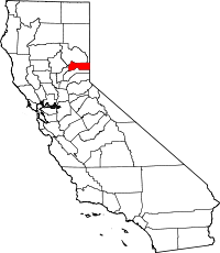
 Placering i delstaten California | |
 Californias placering i USA | |
| Basis data | |
| Grundlagt | 1852 |
|---|---|
| Hovedby | Downieville |
| Største by | Loyalton |
| Areal - I alt - Land - Vand | 2.490 km² 2.470 km² 20 km² |
| Befolkningstal - år 2010 Befolkningstæthed | 3.240 1,3 indb/km² |
| Tidszone | PST : UTC-8/-7 |
| Hjemmeside: www.sierracounty.ws | |
Sierra County er et amt beliggende i den nord-østlige del af den amerikanske delstat Californien, på grænsen til nabostaten Nevada. Hovedbyen i amtet er Downieville. I år 2010 havde amtet 3.240 indbyggere.
Historie
Amtet blev grundlagt i 1852 med areal fra Yuba County i vest.
Geografi
Ifølge United States Census Bureau er Sierras totale areal på 2.490 km², hvoraf de 20 km² er vand.
Grænsende amter
- Nevada County - syd
- Yuba County - vest
- Plumas County - nord
- Lassen County - nordøst
- Washoe County, Nevada - øst
Byer i Sierra
|
|
Eksterne henvisninger
- Sierra Countys officielle hjemmeside Arkiveret 5. november 2020 hos Wayback Machine (engelsk)
Koordinater: 39°35′N 120°31′V / 39.583°N 120.517°V
|
Medier brugt på denne side
Forfatter/Opretter: Huebi, Licens: CC BY 2.0
Map of USA with California highlighted
Flag of California. This version is designed to accurately depict the standard print of the bear as well as adhere to the official flag code regarding the size, position and proportion of the bear, the colors of the flag, and the position and size of the star.
Locator map showing Sierra County (red) — Northern California.
- Located in the northern Sierra Nevada mountain range.
- The northern reach of the 19th-century California Gold Rush prospecting and mining activity in the Sierra's gold fields.


