Shelby County (Texas)
| Shelby County, Texas | |
| Kort | |
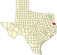
 Placering i delstaten Texas | |
 Texass placering i USA | |
| Basis data | |
| Grundlagt | information mangler |
|---|---|
| Hovedby | |
| Areal - I alt - Land - Vand | |
| Befolkningstal - år Befolkningstæthed | |
 For alternative betydninger, se Shelby County. (Se også artikler, som begynder med Shelby County)
Shelby County er en county i den amerikanske delstat Texas. Den ligger i den østlige del af delstaten. Den grænser mod Panola County i nord, Sabine County og San Augustine County i syd, Nacogdoches County i sydvest og mod Rusk County i nordvest. Den har også grænse mod delstaten Louisiana i øst.
Shelby Countys totale areal er 2.161 km² hvorav 105 km² er vand. I år 2000 havde amten 25.224 indbyggere og administrationscenteret ligger i byen Center. Shelby County er blevet opkaldt efter soldaten Isaac Shelby.
Byer
- Center
- Huxley
- Joaquin
- Shelbyville
- Tenaha
- Timpson
| ||||||||
| Spire |
Koordinater: 31°47′N 94°08′V / 31.79°N 94.14°V
|
Medier brugt på denne side
Forfatter/Opretter: This version: uploader
Base versions this one is derived from: originally created by en:User:Wapcaplet, Licens: CC BY 2.0
Map of USA with Texas highlighted
(c) Lokal_Profil, CC BY-SA 2.5
Map showing Mainland USA ("lower 48") with a superimposed US flag.
This is a locator map showing Shelby County in Texas. For more information, see Commons:United States county locator maps.


