Shebelle

Shebelle
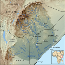
Kort over floder i området. Shebelle har det nordligste og østligste løb

Shebelle er en Afrikansk flod. Den udspringer i Etiopiens bjerge og løber mod sydøst. Efter at have løbet ind i Somalia drejer den mod syd. Omkring 30 km nord for Mogadishu drejer den mod sydvest og løber parallelt med Somalias kyst indtil den forsvinder i sumpområder. Det afhænger af årstiden hvor langt den når. Det hænder at bryder igennem til Jubafloden i år med meget vand. Flodområdet er det eneste sted i Somalia som er frugtbart nok til at dyrke jorden.

Etiopiens geografiSpire
Denne artikel om Etiopiens geografi er en spire som bør udbygges. Du er velkommen til at hjælpe Wikipedia ved at udvide den.
Geografi
somalisk geografiSpire
Denne artikel om somalisk geografi er en spire som bør udbygges. Du er velkommen til at hjælpe Wikipedia ved at udvide den.
Geografi

Koordinater: 0°01′57″S 42°36′15″Ø / 0.0326°S 42.6041°Ø / -0.0326; 42.6041

Medier brugt på denne side

Flag-map of Somalia.svg
Forfatter/Opretter: Darwinek, Licens: CC BY-SA 3.0
Flag-map of Somalia
Jubbarivermap.png
Forfatter/Opretter: Kmusser, Licens: CC BY-SA 3.0
Map showing the Jubba and Shebelle rivers drainage basin.
Shebelefloden.jpg
Forfatter/Opretter:

This image was produced by me, David Castor (user:dcastor). The pictures I submit to the Wikipedia Project are released to the public domain. This gives you the right to use them in any way you like, without any kind of notification. This said, I would still appreciate to be mentioned as the originator whenever you think it complies well with your use of the picture. A message to me about how it has been used would also be welcome. You are obviously not required to respond to these wishes of mine, just in a friendly manner encouraged to. (All my photos are placed in Category:Images by David Castor or a subcategory thereof.)

, Licens: CC0
Shebelle River in Ethiopia.
Flag-map of Ethiopia.svg
Forfatter/Opretter: Darwinek, Licens: CC BY-SA 3.0
Flag-map of Ethiopia