Zaragoza
 For alternative betydninger, se Zaragoza (flertydig). (Se også artikler, som begynder med Zaragoza)
| Zaragoza Zaragoza, Zaragoza | |||||
|---|---|---|---|---|---|
| |||||
 | |||||
| Overblik | |||||
| Land | |||||
| Borgmester | Jorge Azcón | ||||
| Region | |||||
| Provins | Zaragoza | ||||
| Comarca | Zaragoza | ||||
| Postnr. | 50001–50022 | ||||
| Telefonkode | 976 | ||||
| Nummerpladebogstav(er) | Z | ||||
| Demografi | |||||
| Indbyggere | 673.010 (2022) | ||||
| - Areal | 974 km² | ||||
| - Befolkningstæthed | 691 pr. km² | ||||
| Andet | |||||
| Tidszone | UTC+1 | ||||
| Højde m.o.h. | 200 m | ||||
| Hjemmeside | www.zaragoza.es | ||||
| Oversigtskort | |||||
| Aragoniens beliggenhed | |||||
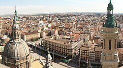
Zaragoza (tidligere Saragossa, latin: Caesaraugusta) er hovedstad i den autonome spanske region og det tidligere kongerige Aragón og provinsen Zaragoza. Byen har 673.010(2022) indbyggere.
Zaragoza er vokset op hvor floden Ebro samler de to bifloder Huerva og Gállego. Den er et trafikknudepunkt omkring 300 km. fra de fire storbyer Madrid, Barcelona, Valencia og Bilbao. AVE-hurtigtoget fra Barcelona til Madrid går gennem byen.
Zaragoza var vært for verdensudstillingen EXPO 2008, som havde vand og bæredygtighed som gennemgående tema. Betydende virksomheder i byen er General Motors bilfabrik, der fremstiller Opel-modeller, CAF (Construcciones y Auxiliar de Ferrocarriles), der bygger lokomotiver og togsæt. Byen rummer også en flybase og andre militære installationer.
Sammen med det nærliggende vintersportssted Jaca kandiderede Zaragoza til de olympiske vinterlege i 2014.
Referencer
Eksterne henvisninger
| |||||||||||||||||||||||||||||||||
|
Medier brugt på denne side
The Flag of Europe is the flag and emblem of the European Union (EU) and Council of Europe (CoE). It consists of a circle of 12 golden (yellow) stars on a blue background. It was created in 1955 by the CoE and adopted by the EU, then the European Communities, in the 1980s.
The CoE and EU are distinct in membership and nature. The CoE is a 47-member international organisation dealing with human rights and rule of law, while the EU is a quasi-federal union of 27 states focused on economic integration and political cooperation. Today, the flag is mostly associated with the latter.
It was the intention of the CoE that the flag should come to represent Europe as a whole, and since its adoption the membership of the CoE covers nearly the entire continent. This is why the EU adopted the same flag. The flag has been used to represent Europe in sporting events and as a pro-democracy banner outside the Union.Flag of Portugal, created by Columbano Bordalo Pinheiro (1857–1929), officially adopted by Portuguese government in June 30th 1911 (in use since about November 1910). Color shades matching the RGB values officially reccomended here. (PMS values should be used for direct ink or textile; CMYK for 4-color offset printing on paper; this is an image for screen display, RGB should be used.)
Flag of Austria with the red in the Austrian national colours which was official ordered within the Austrian Armed Forces (Bundesheer) in the characteristic “Pantone 032 C” (since May 2018 the Red is ordered in the characteristic “Pantone 186 C”.)
Finlands flag
Forfatter/Opretter: caccamo from Milan, Italy, Licens: CC BY-SA 2.0
16x pictures stiched together with some cropping for a narrow but taller view. A stunning view from the top of the Cathedral
4694 x 2598 pixelsForfatter/Opretter:
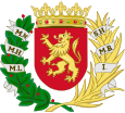
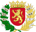
Coat of Arms of Saragossa.
Forfatter/Opretter: TUBS
Location of region xy (see filename) in Spain.
Forfatter/Opretter: Ulaidh, Licens: CC BY-SA 4.0
Bandera de la ciudad de Zaragoza (España)
Forfatter/Opretter: NordNordWest, Licens: CC BY-SA 3.0
Location map of Spain
Equirectangular projection, N/S stretching 130 %. Geographic limits of the map:
- N: 44.4° N
- S: 34.7° N
- W: 9.9° W
- E: 4.8° E
