Santa Ana (Californien)
Santa Ana | |||||
|---|---|---|---|---|---|
| |||||
 | |||||
| Overblik | |||||
| Land | |||||
| Borgmester | Vicente Sarmiento | ||||
| Grundlagt | 1869 | ||||
| Postnr. | 92701–92708, 92711, 92712, 92728, 92735, 92799 | ||||
| Demografi | |||||
| Indbyggere | 310.227 (2020)[1] | ||||
| Andet | |||||
| Højde m.o.h. | 35 m | ||||
| Hjemmeside | www.santa-ana.org | ||||
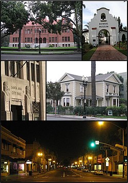
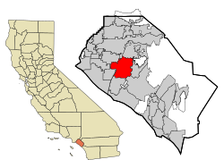
Santa Ana er en amerikansk by og administrativt centrum i det amerikanske county Orange County, i staten Californien. Byen har 310.227(2020)[1] indbyggere.
Referencer
- ^ a b 2020 United States Census, hentet 1. januar 2022 (fra Wikidata).
Ekstern henvisning
- Santa Anas hjemmeside (engelsk)
| Spire |
|
Koordinater: 33°44′27″N 117°52′53″V / 33.7408°N 117.8814°V
Medier brugt på denne side
(c) Lokal_Profil, CC BY-SA 2.5
Map showing Mainland USA ("lower 48") with a superimposed US flag.
Forfatter/Opretter: Dthx1138, Avalos714, Bowersprintern, Licens: CC BY-SA 3.0
Collage of photos in Santa Ana, California
Forfatter/Opretter: Arkyan, Licens: CC BY-SA 3.0
This map, highlighting Santa Ana in red, shows the incorporated and unincorporated areas in Orange County, California.
- It was created with a custom script with US Census Bureau data and modified with Inkscape.


