San Francisco
| San Fransisco San Fransisco | |||||
|---|---|---|---|---|---|
| |||||
 | |||||
| Overblik | |||||
| Land | |||||
| Motto | Oro en Paz, Fierro en Guerra (Oversat fra Spansk: Guld i fred, jern i krig) | ||||
| Borgmester | London Breed (siden 2017) | ||||
| Grundlagt | 29. juni 1776 | ||||
| Postnr. | 94101–94112, 94114–94147, 94150–94170, 94172, 94175, 94177 | ||||
| Demografi | |||||
| - Areal | 121.4 km² | ||||
| - Befolkningstæthed | 6,632.9 pr. km² | ||||
| Andet | |||||
| Tidszone | Pacific Standard Time (UTC -8) | ||||
| Højde m.o.h. | 16 m | ||||
| Hjemmeside | www.sfgov.org | ||||
| Oversigtskort | |||||
 San Fransisco | |||||
San Francisco (spansk for "Sankt Frans"; officielt The City and County of San Francisco, også uofficielt kaldet SF, San Fran, Frisco og The City[1][2]) er en amerikansk by i delstaten Californien.[3] Byen er med sine 837.442[4] (2013) indbyggere Californiens fjerdestørste. San Francisco indgår dog i en stor metropol kaldet The San Francisco Bay Area med hele 7 millioner indbyggere.
San Francisco er kendt for månedlange tågebanker, stejle bakker og byens liberale kulturelle, seksuelle og politiske identitet. San Francisco fik i 2007 stor landspolitisk indflydelse med valget af Nancy Pelosi – der repræsenterer Californiens 12. kongresdistrikt, der omfatter det meste af San Francisco – som formand for det ene af USA's kongres' kamre; Repræsentanternes Hus. Også Dianne Feinstein, den ene af Californiens to senatorer, er fra byen.
Historie
I 1776, koloniserede spanierne toppen af San Francisco halvøen. Som et resultat af Guldfeberen i Californien i 1848, kom byen ind i en periode med stor vækst. Efter at være blevet ødelagt af jordskælv og efterfølgende brand i 1906, blev byen hurtigt genopbygget.
Byens udformning
Arkitektur
Berømte bygninger og steder inkluderer Golden Gate Bridge, Alcatraz, kabeltog, Transamerica-pyramiden, Coit Tower, Chinatown, Haight Ashbury og Fisherman's Wharf.
Billeder
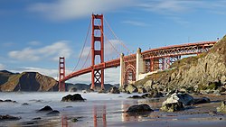 © Frank Schulenburg, CC BY-SA 4.0Golden Gate-broen, 2018
 Transamerica-pyramiden og Sentinel-bygningen i det nordlige San Francisco, 2003
 Lavthængende tåge over bydelen "Outer Sunset", 2023
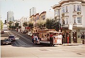 Kabelvogn på Hyde Street, 1990
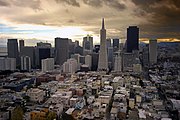 Det finansielle distrikt set fra luften, 2007
 Himlen over byens rådhus farves rød af skovbrande i Californien, 2020
 En af San Franciscos mange tusinde hjemløse sidder på gaden, 2012
- Et af USA's mest kendte fængsler, Alcatraz, ses i ligge i byens bugt, 2022
 Den gamle færgebygning på Embarcadero med det finansielle distrikt bag sig, 2019
 Downtown San Francisco og Bay Bridge til Oakland set fra luften, 2010
Trivia
- Området Silicon Valley, syd for selve byen var centrum i IT-boomet, det såkaldte dot com-boblen.
Referencer
- ^ Rose, Aimee (2016-11-28). "The Best Nicknames For San Francisco" (engelsk). Culture Trip. Arkiveret fra originalen 12. august 2019. Hentet 2020-06-02.
- ^ "Brinklow" (engelsk). Curbed San Francisco. 2018-01-26. Hentet 2020-06-02.
{{cite web}}:|first=mangler|last=(hjælp) - ^ "San Francisco | lex.dk – Den Store Danske", lex.dk, hentet 21. oktober 2023
- ^ "San Francisco History - Population". Arkiveret fra originalen 4. oktober 2013. Hentet 11. januar 2012.
Eksterne henvisninger
| Spire |
Medier brugt på denne side


A 1×1 transparent image. Useful for when a template requires an image but you don't have one.

(c) Lokal_Profil, CC BY-SA 2.5
Map showing Mainland USA ("lower 48") with a superimposed US flag.


Forfatter/Opretter: Dllu, Licens: CC BY-SA 4.0
Nighttime view of the San Francisco skyline with the Ferry Building in the center from Treasure Island. In the center, the foggy air is illuminated by glow from Market Street.

Forfatter/Opretter: BriefEdits, Licens: CC BY-SA 4.0
Orange tinted skies at Civic Center, by City Hall, in San Francisco on September 9, 2020 due to the North Complex Fires. Photo was taken in front of the Main Library.

Simple Vectorization of the Seal of the City and County of San Francisco

Forfatter/Opretter: Andrew Bone from Weymouth, England, Licens: CC BY 2.0
1990 San Francisco cable car

Forfatter/Opretter: Kefr4000, Licens: CC BY-SA 4.0
Low hanging fog over San Francisco as seen from Strawberry Hill, Golden Gate Park
.jpg)
Forfatter/Opretter: Tony Webster from Portland, Oregon, United States, Licens: CC BY 2.0
The skyline from Coit Tower

Forfatter/Opretter: JCruzTheTruth, Licens: CC BY-SA 4.0
Homeless Epidemic in San Francisco

Forfatter/Opretter: Graham Rogers (Rodge500), Licens: CC BY-SA 2.5
Downtown San Francisco, showing the Transamerica Pyramid, designed by William Pereira

San Francisco earthquake 1906 - panoramic view
View of the destruction brought about by the San Francisco Earthquake, 1906 Records of the Office of the Chief Signal Officer (Army) (111-AGF-1-A-D)
This is a composite panorama, meaning that it is pieced together from four separate images to give a panoramic effect. The photographer is unknown, though it may have been taken by the Army Signal Corps. It is printed on silver gelatin paper.
The photo was taken from the site of the Stanford Mansion, later the Stanford Court hotel, on Powell Street, between California St. and Pine St.
The square bell tower in the left frame is that of: Old Saint Mary's Church, 660 California, San Francisco, CA 94108
Forfatter/Opretter: Edward Betts, Licens: CC BY-SA 3.0
w:San Francisco Bay from the air in May 2010.
%2c_Lombard_Street%2c_Blick_auf_Alcatraz_--_2022_--_3080.jpg)
Forfatter/Opretter: NordNordWest, Licens: CC BY-SA 3.0
Location map of the United States ("lower 48")

© Frank Schulenburg, CC BY-SA 4.0
Golden Gate Bridge as seen from Marshall’s Beach, Presidio of San Francisco, in March 2018