Rice County (Minnesota)
 For alternative betydninger, se Rice County. (Se også artikler, som begynder med Rice County)

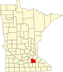
Rice County er et county i den amerikanske delstat Minnesota. Rice County ligger i den sydøstlige del af delstaten og grænser op til Dakota County i nordøst, Goodhue County i øst, Dodge County i sydøst, Steele County i syd, Waseca County i sydvest, Le Sueur County i vest og mod Scott County i nordvest.
Rice Countys totale areal er 1.337 km², hvoraf 48 km² er vand. I 2000 havde Rice County 56.665 indbyggere. Administrativt centrum er i byen Faribault som også er county'ets største by.
Rice County har fået sit navn efter senator Henry Mower Rice.
Koordinater: 44°22′N 93°18′V / 44.36°N 93.3°V
|
Medier brugt på denne side
The flag of Minnesota, since May 11, 2024.
This is a locator map showing Rice County in Minnesota. For more information, see Commons:United States county locator maps.

