Rev

Rev (synonymt med grund, barn og flak og ofte anvendt synonymt med banke) er den maritime betegnelse for en undersøisk ryg nær havoverfladen. De kan bestå af forskelligt materiale som klipper, sand, mudder e.l. Vanddybden over revene er ofte så lille, at der optræder bølgebrænding.
Former
Der findes mange former og navne for rev. Her er nogle flere eksempler:
- Stenrev
- Muslingebanker
- Koralrev
- Boblerev
- Undersøiske klippefremspring
Der er ikke umiddelbart knyttet en speciel geologisk materialetype eller dannelsesmåde til rev, banke, grund, barn eller flak. Kender man det geologiske materiale og ønsker man at fremhæve det, kan man f.eks. tale om en sandbanke, mudderbanke, kalkgrund, stengrund, osv.. Banke er samtidigt et gammel ord for bakke. En toppet grund kaldes også en pulle. Rev ses i daglig tale indimellem brugt om landtanger og mere oversøiske fænomener som f.eks. Hindens rev.
Revene i havet er ofte oaser af liv og det kan til tider være nødvendigt at beskytte dem, af hensyn til fiskebestandene og den biologiske diversitet i oceanerne. De kan trues af stenfiskeri, sandsugning, bundtrawl, temperatur udsving og visse klima forandringer.
Rev udgør ofte en fare for skibsfarten, selv i vore dage.
Natura 2000
Rev er en naturtype i Natura 2000 med betegnelsen 1170 Rev. I de danske farvande findes en lang række rev både i Nordsøen i det nordlige Kattegat og ned gennem bælterne (storebælt og lillebælt, samt og i Østersøen omkring Bornholm. Variationer i bl.a. saltholdighed og dybde giver de enkelte rev en stor variation af dyr og planter, som ofte er helt forskellig fra andre, selv nærliggende rev.[1][2]
Galleri
 Koralrevene omkring Ny Kaledonien, set fra NASAs Terra satellit. Verdens mest alsidige rev-strukturer ifølge UNESCO.
 (c) User: (WT-shared) Pbsouthwood at wts wikivoyage, CC BY-SA 3.0Tangskov på et rev ved Partridge Point (Sydafrika)
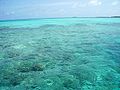 Rev ved Maldiverne
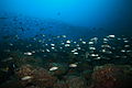 Stenrev ved Panama
 Rev af klippeskær ved Færøerne
 (c) P Richard B Smith, CC BY-SA 2.0Dele af de tangbevoksede 'An Gobhlach' rev omkring Isle of Pabay i Skotland
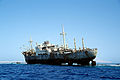 (c) Roland Unger, CC BY-SA 3.0
 Vrag af sejlbåd på Minerva Revet ved Tonga (Stillehavet). 2005.
Se også
Referencer og Kilder
- ^ Habitatbeskrivelser, årgang 2016 Arkiveret 24. maj 2018 hos Wayback Machine mst.dk p6
- ^ Fredshavn, Jesper; Nygaard, Bettina; Ejrnæs, Rasmus; Damgaard, Christian; Therkildsen, Ole Roland; Elmeros, Morten; Wind, Peter; Johansson, Liselotte Sander; Alnøe, Anette Baisner; Dahl, Karsten; Nielsen, Erik Haar; Pedersen, Helle Buur; Sveegaard, Signe; Galatius, Anders; Teilmann, Jonas (2019). Bevaringsstatus for naturtyper og arter – 2019, Habitatdirektivets Artikel 17-rapportering (PDF). Aarhus: Aarhus Universitet, DCE – Nationalt Center for Miljø og Energi. s. 12. ISBN 978-87-7156-437-2. Hentet 1. november 2019.
- Erik Buchwald og Steen Søgaard (red): Danske naturtyper i det europæiske NATURA 2000 netværk Arkiveret 24. maj 2018 hos Wayback Machine Miljø- og Energiministeriet, Skov- og Naturstyrelsen, 2000; ISBN 87-7279-275-2
- Rev i Den Store Danske på Lex.dk (rev og flak)
- Stenrev - Havets Oaser DMU (2003)
| |||||||||||||||||||||||||||||||||||||||||||||||||||||||||||||||||||||||||||||
| Spire Denne artikel om geografi er en spire som bør udbygges. Du er velkommen til at hjælpe Wikipedia ved at udvide den. |
|
Medier brugt på denne side

Roughly 1,300 kilometers (830 miles) east of Australia lies Grande Terre, the largest island of New Caledonia. The island is roughly 400 kilometers (250 miles) long and ringed by a 1,600-kilometer (1,000-mile) coral reef.
Cloud-free skies allowed the Moderate Resolution Imaging Spectroradiometer (MODIS) on NASA’s Terra satellite a clear view of Grande Terre on September 24, 2012. Coral reefs, appearing iridescent blue-green through the seawater, surround the mostly vegetation-coated island.
New Caledonia has a hot and humid climate, but conditions vary between the coasts of Grande Terre. Trade winds from the southeast bring relatively cool, moist air to the eastern part of the island, where rich forests fill the coastal strip east of the mountains. In the west lie open, arid plains. Between the east and west coasts, a mountain range forms the island’s spine. The tallest point is Mont Panié with an elevation of 1,628 meters (5,341 feet) above sea level.
The British explorer James Cook gave New Caledonia its name because its mountains reminded him of Scotland (once named Caledonia). In the years since his expedition, geologists have teased New Caledonia’s history from clues in the rock record. New Caledona was once a part of Gondwana, an ancient supercontinent that broke apart tens of millions of years ago. New Caledonia drifted northeastward and finally settled in its current position about 50 million years ago. Between 45 and 33 million years ago, tectonic plates colliding with each other uplifted the region, including part of the sea floor. Once elevated, New Caledonia began to erode, thanks to the action of wind and water.
New Caledonia’s rocks are unusually rich in iron, magnesium, and nickel; in fact, the island is home to about a quarter of the world’s known nickel resources. Meanwhile the soils are poor in nitrogen, calcium, phosphorus, and potassium, and plant life has had to adapt. About 75 percent of New Caledonia’s plant species are found only the island, placing New Caledonia third, after Hawaii and New Zealand, for endemic plant species.
Marine life around New Caledonia rivals the unique plant life. The United Nations Educational, Scientific and Cultural Organization (UNESCO) characterizes the reef system as “the world’s most diverse concentration of reef structures.” The reef, mangrove, and seagrass habitats provide homes to fish, marine invertebrates, marine mammals (such as whales and dugongs), and turtles.
(c) User: (WT-shared) Pbsouthwood at wts wikivoyage, CC BY-SA 3.0
Kelp forest on high profile reef at Partridge Point, Cape Peninsula.

Forfatter/Opretter: No machine-readable author provided. Jolle~commonswiki assumed (based on copyright claims)., Licens: CC BY-SA 3.0
Arrecife en las Islas Maldivas; foto hecho por J. Ollé en julio de 2006.
.jpg)
Forfatter/Opretter: LASZLO ILYES from Cleveland, Ohio, USA, Licens: CC BY 2.0
A cloud of healthy marine life, accented by a large school of various assorted grunts (Haemulon) in the foreground, blankets the rocky reef at Czech Point dive site in the waters of Coiba National Park, Panama.
On an interesting note, we were serenaded by a Humpback whale throughout most of this dive. My dive guide Jeremy believed the whale to be no more than a mile from us, but we never did see it. Nevertheless, to me it's song was unforgettable. (Sound byte courtesy of the San Diego Zoo website).
Day 5
Forfatter/Opretter: EileenSanda, Licens: CC BY-SA 3.0
Heltnarnar is a skerry or rocky reef on Vágseiði west of the village Vágur, Faroe Islands. Vágur is a village on the southernmost island, Suðuroy (South Island). The sea is often rough around the skerry Heltnarnar. This place used to be in use as a fishing harbour in the 19th and early 20th century.

(c) P Richard B Smith, CC BY-SA 2.0
The end of Pabay jetty is built onto part of the reef. In this image just as we are departing from The Isle of Pabay one looks over the gradually exposing reefs of An Gobhlach. If one looks at the image carefully one can just discern the rock of Sgeir Gobhlach which has a beacon on it. It is the further most exposed part of the reef and is located in grid reference 6625. In the far distance is the hill of Beinn na Caillich on The Isle of Skye.

(c) Roland Unger, CC BY-SA 3.0
Wreck of the MS Loullia in 1998, Gordon Reef, Sinai, Egypt

sailboat wreck at North Minerva Reef, Tonga, Pacific Ocean

Forfatter/Opretter: Malene Thyssen, Licens: CC BY-SA 3.0
Nyudsprungne bøgetræer i Gribskov på Nordsjælland.