Randhav


Randhav har typisk to betydninger.
I oceanografi er et randhav et delvist lukket hav som grænser op til et ocean på havoverfladen, mens det er afgrænset af undersøiske højderygge på havbunden.[1]
I geopolitik er et randhav lig med territorialfarvand.[2] Defineringen af territorielt farvand er vigtig af hensyn til efterforskningen og udvindingen af naturressourcer.[3]
Randhave i Verden

Randhave i Ishavet:
- Barentshavet
- Beauforthavet
- Chukchihavet (adskilt af Wrangel-øen)
- Karahavet[4]
- Laptevhavet (adskilt af Severnaya Zemlya og New Siberian Islands)[5]

Randhave i Atlanterhavet:
- Argentinske Hav
- Østersøen[3]
- Caribiske Hav[3]
- Engelske Kanal
- Mexicanske Golf
- Hudson Bay[1]
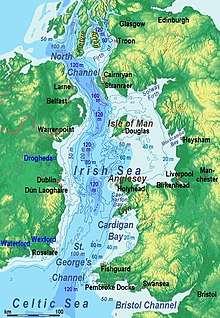
- Irske Hav (adskilt af Irland)[3]
- Middelhavet[3]
- Nordsøen (adskilt af Storbritannien)[3]
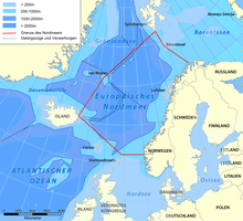
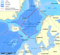
- Norskehavet (adskilt af Island, Færøerne, Shetlandsøerne); og Grønlandske Hav[3]
- Skotske Hav (adskilt af Falklandsøerne, Sydgeorgien og South Sandwich Islands)
- Sommetider defineres Ishavet som et randhav i Atlanterhavet.[3][6]
Randhave i Indiske Ocean:
- Andamanhavet (adskilt af Andaman-øerne og Nicobarerne).[7]
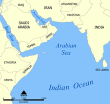
- Arabiske Hav
- Bengalske Bugt
- Javahavet (adskilt af Greater Sunda Islands)
- Persiske Golf[3]
- Rødehavet[3]
- Zanjhavet (en historisk enhed ved den sydøstafrikanske kyst og inklusiv Mascarene-øerne)

Randhave i Middelhavet:
- Adriaterhavet
- Græske Hav
- Alboran Sea
- Balearic Sea
- Sortehavet[3]
- Kretahavet
- Ioniske Hav
- Ligurian Hav
- Myrtoan Hav
- Thracian Hav
- Tyrrhenian Hav
Randhave i Sortehavet:

Randhave i Stillehavet:
- Beringshavet (adskilt af Aleutian Islands)
- Celebeshavet[3]
- Koralhavet (adskilt af Solomon-øerne og Vanuatu).[3]
- Østkinesiske Hav (adskilt af Ryukyu-øerne)
- Filippinske Hav (adskilt af Ogasawara-øerne, Marianerne og Palau)
- Chilehavet (adskilt af Chiloé-øen, Chile)
- Japanske Hav (adskilt af Japan)[3]
- Okhotske Hav (adskilt af Kurilerne og Kamchatka)
- Sydkinesiske Hav (adskilt af Filippinerne)[3]
- Suluhavet[3]
- Tasmanske Hav (mellem Australien og New Zealand)
- Gule Hav (adskilt af Korea)[1]
Randhave i Sydlige Ishav:
- Skotske Hav
Caribiske Hav defineres sommetider som et randhav,[3] sommetider som et indhav.[1]
Kilder
- ^ a b c d American Congress on Surveying and Mapping (1994). Glossary of the mapping sciences. ASCE Publications. s. 469. ISBN 978-0-7844-0050-0. Hentet 9. december 2010.
- ^ George M. Cole (21. marts 1997). Water boundaries. John Wiley and Sons. s. 137-139. ISBN 978-0-471-17929-0. Hentet 9. december 2010.
- ^ a b c d e f g h i j k l m n o p q James C. F. Wang (1992). Handbook on ocean politics & law. Greenwood Publishing Group. s. 14–. ISBN 978-0-313-26434-4. Hentet 9. december 2010.
- ^ Kara Sea, Encyclopædia Britannica
- ^ Laptev Sea, Encyclopædia Britannica
- ^ Longhurt, Alan R. (2007). Ecological Geography of the Sea. Academic Press. s. 104. ISBN 978-0-12-455521-1. Hentet 13. december 2010.
- ^ Andaman Sea, Encyclopædia Britannica
|
Medier brugt på denne side
Forfatter/Opretter: NormanEinstein, Ras67, Licens: CC BY-SA 3.0
A map showing the location of the Arabian Sea in the Indian Ocean. Created by NormanEinstein, July 19, 2005.
Forfatter/Opretter: NormanEinstein, Licens: CC BY-SA 3.0
Map showing the location of the Coral Sea, bounded by Australia, Papua New Guinea, Solomon Islands, Vanuatu, and New Caledonia. Nearby bodies of water include the Tasman Sea, Solomon Sea, and South Pacific Ocean.
Forfatter/Opretter: Created by User:NormanEinstein, May 20, 2005., Licens: CC BY-SA 3.0
A map showing the location of the Ionian Sea.
Forfatter/Opretter: old one Users SFC9394, Seabhcan on en.wikipedia, new one Ulamm (talk) 01:37, 11 May 2014 (UTC), Licens: CC BY-SA 3.0
A map of the en:Irish Sea. Major ports shown with red marks. freight-only ports in blue.
The old map with this lemma had significant mistakes of the bathymetry.
Forfatter/Opretter:
- Oceans_and_seas_boundaries_map-fr.svg: Pinpin
- derivative work: Jugger90 (talk)
- derivative work: Dziban303 (diskussion) 02:20, 5 April 2021 (UTC)
World map of oceans and seas : English version
Forfatter/Opretter: selber, Licens: CC BY 3.0
Europäisches Nordmeer mit Grenzen und Tiefenangaben (entspricht nicht den IHO-Grenzen)


