Røsnæs

Røsnæs eller Refsnæs er en halvø på Nordvestsjælland mellem Kalundborg Fjord og Sejerøbugten.
Spidsen af halvøen med Røsnæs Fyr er Sjællands vestligste punkt. Syd for Røsnæs går fjorden ind til Kalundborg Havn. Fjorden afgrænses mod syd af Asnæs, en anden landtange.
Midt på halvøen findes landsbyen Ulstrup.
Røsnæsgården blev købt af staten i 1964 for at gøre området mere tilgængeligt for befolkningen. Arealet er på 200 ha. og der er blandt andet en naturlejrplads. I Skanseskoven på nordsiden af halvøen er der et rigt fugleliv, og den er en yndet rasteplads for trækfugle.
På Røsnæs lå Kysthospitalet på Refsnæs, som i dag er Synscenter Refsnæs.
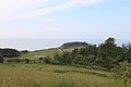 (c) chrisi123456, CC BY 3.0Spidsen af Røsnæs set fra Vågehøj
 Kort fra 1808 over skansen på halvøens spids
 Christian Mølsteds maleri af klinten ved Nostrup
 Kongstrup Klint
Eksterne henvisninger
| Spire Denne artikel om geografi i Kalundborg Kommune er en spire som bør udbygges. Du er velkommen til at hjælpe Wikipedia ved at udvide den. |
| ||||||||||||||||||||||
|
Koordinater: 55°44′N 11°00′Ø / 55.733°N 11.000°Ø
Medier brugt på denne side

Map of Denmark with flag.


Forfatter/Opretter: Thomas Dahlstrøm Nielsen, Licens: CC BY-SA 4.0
Kongstrup stendysse 2021
(c) MonoSupreme, CC BY-SA 3.0
View from Roesnaes Lighthouse


_in_1808.jpg)
Sketch from 1808 of the cannon batteries at the Røsnæs peak. The tip of Røsnæs, also called Refsnæs, is Zealand's westernmost point. In 1964. The Danish government purchased Røsnæsgården to make the area more accessible to the population. The area is 200 hectares.
Just west of the Fisherman's House that was built around 1900 for the fisherman. Hillebrandt is a fortress hill, how old it is is not known, but is known to exist before the England wars. In order to prevent hostile landing (after the loss of the fleet to England in 1801 and 1807), the batteries were extended and supplemented by a battery at the Skanseskov, as well as a battery where the lighthouse now lies. The guns could fire about a mile with grenades of up to 24 pounds. Only the main battery was permanently manned - the others were equipped with guns based on needs.