Puy de Sancy
| Puy de Sancy | |
|---|---|
 Puy de Sancy | |
| Højeste punkt | |
| Højde | 1.885 m |
| Koordinater | 45°31′42″N 2°48′51″Ø / 45.52833°N 2.81417°ØKoordinater: 45°31′42″N 2°48′51″Ø / 45.52833°N 2.81417°Ø |
| Geografi | |
 Puy de Sancy | |
| Land | Frankrig |
| Område | Auvergne-Rhône-Alpes |
| Bjergområde | Centralmassivet |
Puy de Sancy er det højeste bjerg i Centralmassivet og centrale område af Frankrig, og det højeste i landet udenom Alperne og Pyrenæerne. Bjerget har en højde på 1.885 meter over havet.
Bjerget er en del af en gammel stratovulkan, som har været udslukt i 220.000 år.
Galleri

Udsigt fra Puy de Sancy


Puy Ferrand set fra Puy de Sancy
Udsigt from Puy de Sancy
Kildehenvisninger
Eksterne henvisninger
|
Medier brugt på denne side

RedMountain.svg
a map symbol for a mountain, the center is in the middle of the base line - as opposed to Fire.svg
a map symbol for a mountain, the center is in the middle of the base line - as opposed to Fire.svg
Puy de Sancy.JPG
Forfatter/Opretter: Myself - Herby talk thyme, Licens: CC BY-SA 4.0
Le Mont-Dore, Puy-de-Dôme, France. View of the peak of Puy de Sancy.
Forfatter/Opretter: Myself - Herby talk thyme, Licens: CC BY-SA 4.0
Le Mont-Dore, Puy-de-Dôme, France. View of the peak of Puy de Sancy.

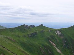
The three on Puys.JPG
Forfatter/Opretter: Myself - Herby talk thyme, Licens: CC BY-SA 4.0
View from Puy de Dancy.
Forfatter/Opretter: Myself - Herby talk thyme, Licens: CC BY-SA 4.0
View from Puy de Dancy.

Puy Ferrand.jpg
Forfatter/Opretter: unknown, Licens:
Forfatter/Opretter: unknown, Licens:

Mont Dore vu du Sancy.JPG
Forfatter/Opretter: Jacques Le Letty, Licens: CC BY-SA 3.0
Le Mont Dore vu du Sancy
Forfatter/Opretter: Jacques Le Letty, Licens: CC BY-SA 3.0
Le Mont Dore vu du Sancy

Le Capucin depuis le Sancy.jpg
Seen from the summit of the puy de Sancy (Puy-de-Dôme, France),the Capucin and the Banne d'Ordanche.
Seen from the summit of the puy de Sancy (Puy-de-Dôme, France),the Capucin and the Banne d'Ordanche.
France relief location map.jpg
Forfatter/Opretter: Eric Gaba (Sting - fr:Sting), Licens: CC BY-SA 4.0
Blank physical map of metropolitan France for geo-location purpose.
Scale : 1:14 816 000 (accuracy : about 3,7 km) for the bathymetry. More maps of France, view → Commons Atlas of France.
Forfatter/Opretter: Eric Gaba (Sting - fr:Sting), Licens: CC BY-SA 4.0
Blank physical map of metropolitan France for geo-location purpose.
Scale : 1:14 816 000 (accuracy : about 3,7 km) for the bathymetry. More maps of France, view → Commons Atlas of France.