Porto

Denne artikel omhandler byen. For det postale begreb, se frankering.
| Porto o Porto | |||||
|---|---|---|---|---|---|
| |||||
 | |||||
| Overblik | |||||
| Land | |||||
| Borgmester | Rui Moreira | ||||
| Demografi | |||||
| Indbyggere | 237.591 (2011)[1] | ||||
| Andet | |||||
| Tidszone | UTC±00:00 | ||||
| Højde m.o.h. | 104 m | ||||
| Hjemmeside | www.cm-porto.pt | ||||
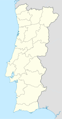
| Oversigtskort | |||||
Porto eller Oporto (portugisisk: o Porto; Havnen) er en by i det nordlige Portugal. Den ligger ved Douro-flodens udmunding i Atlanterhavet og er med sine 2,1 mill. indbyggere (hele byområdet) (2011) Portugals næststørste by. Selve bykernen har 237.591(2011)[1] indbyggere.
Kultur
Byen gav navn til "portvin". Fra 18. århundrede udførte området meget vin til England da forsyninger fra Frankrig ofte var afbrudt på grund af krig.
Byens historiske centrum er på UNESCO's verdensarvsliste.
I 2001 var Porto europæisk kulturhovedstad og i den forbindelse blev flere projekter gennemført. Herunder koncerthallen Casa Da Musica, der stod færdig i 2005 efter tegning af den hollandske arkitekt Rem Koolhaas.
Sport
Porto har en fodboldklub ved navn FC Porto
Geografi
Klima
Klimaet i Porto er normalt koldere end i Lissabon, der ligger ca. 320 km sydligere end Porto. Bjergkæden Serra do Marão længere inde i landet er vindyrkningsområde for portvin.
Eksterne henvisninger
| |||||||||||||||||||||||||||||||||
|
- ^ a b National Institute of Statistics, hentet 19. september 2018 (fra Wikidata).
Medier brugt på denne side
Flag of Portugal, created by Columbano Bordalo Pinheiro (1857–1929), officially adopted by Portuguese government in June 30th 1911 (in use since about November 1910). Color shades matching the RGB values officially reccomended here. (PMS values should be used for direct ink or textile; CMYK for 4-color offset printing on paper; this is an image for screen display, RGB should be used.)
A 1×1 transparent image. Useful for when a template requires an image but you don't have one.
The Flag of Europe is the flag and emblem of the European Union (EU) and Council of Europe (CoE). It consists of a circle of 12 golden (yellow) stars on a blue background. It was created in 1955 by the CoE and adopted by the EU, then the European Communities, in the 1980s.
The CoE and EU are distinct in membership and nature. The CoE is a 47-member international organisation dealing with human rights and rule of law, while the EU is a quasi-federal union of 27 states focused on economic integration and political cooperation. Today, the flag is mostly associated with the latter.
It was the intention of the CoE that the flag should come to represent Europe as a whole, and since its adoption the membership of the CoE covers nearly the entire continent. This is why the EU adopted the same flag. The flag has been used to represent Europe in sporting events and as a pro-democracy banner outside the Union.Flag of Austria with the red in the Austrian national colours which was official ordered within the Austrian Armed Forces (Bundesheer) in the characteristic “Pantone 032 C” (since May 2018 the Red is ordered in the characteristic “Pantone 186 C”.)
Finlands flag
Forfatter/Opretter: Brian Boru, Licens: CC BY-SA 3.0
Flag of Porto municipality - Portugal.
Forfatter/Opretter: Concierge.2C, Licens: CC BY-SA 3.0
This monument is classified as
It is indexed in the IGESPAR database (
It is indexed in the SIPA database (Sistema de Informação para o Património Arquitectónico) under the reference 5530.
Forfatter/Opretter:
Coat of arms of Porto
Forfatter/Opretter: Rititaneves, Licens: CC BY-SA 3.0
| This file was uploaded for Wiki Loves Monuments in Portugal with the unique identifier 11871408.
|
Forfatter/Opretter: Taken by User:Olegivvit. Edited by Diliff. Brightened shadows with Shadow/Highlights tool in PS CS2, Licens: CC BY 2.5
Historical part of Porto, a World Heritage Site seen from Vila Nova de Gaia, trough the Douro river.
At the right, the metallic Luiz I (Dom Luís Bridge) with the northern tip of the Infante bridge behind it. At its left, the whole historic center with the Clérigos Tower in the horizon. The plaza in the middle is the Ribeira plaza. In the leftmost part of the picture, the Arrábida bridge. The picture also shows the typical rabelo boats, once used for the transport of Port wine.
Forfatter/Opretter: Andre.Figueiredo, Licens: CC BY-SA 3.0
Clérigos Tower in Porto's Historic Center
Forfatter/Opretter: NordNordWest, Licens: CC BY-SA 3.0
Location map of Portugal


