Phoenix (rumsonde)
 For alternative betydninger, se Phoenix. (Se også artikler, som begynder med Phoenix)
| Phoenix | ||
 En kunstners opfattelse a Phoenix-sonden under landing på Mars | ||
| Lander | ||
|---|---|---|
| Organisation: | NASA | |
| Instrumenter: | RAC, SSI, TEGA, MARDI, MECA og MET | |
| Opsendelsesdato: | 4. august 2007 | |
| Opsendelsessted: | Cape Canaveral, Florida | |
| Opsendelsesraket: | Delta II 7925 | |
| Missionens afslutning: | januar 2008 (5 måneder) 3 mdr længere end beregnet | |
| NSSDC ID: | 2007-034A | |
| Masse: | 350 kg | |
| Størrelse: | 5,5 X 1,5 X 2,2 m | |
Phoenix eller Phoenix Mars Lander er et ubemandet rumfartøj, der har som mission at lande tæt på nordpolen af Mars. Rumsonden har et sæt af videnskabelige instrumenter om bord, der har som formål at undersøge om miljøet på Mars kan eller har kunnet understøtte liv og undersøge vandets historie. Phoenix blev opsendt uden problemer 4. august 2007 og landede på Mars 25. maj 2008. Udviklingen af rumsonden er foregået som et samarbejde mellem adskillige instanser hvor University of Arizona under ledelse af NASA har haft det overordnede ansvar. De andre bidrag kommer fra NASA, det canadiske rumagentur, den amerikanske luftfartsindustri og universiteter i USA, Canada, Schweiz, Danmark og Tyskland. Fra Danmark deltager både Aarhus Universitet og Københavns Universitet.
Phoenix landede i Vastitas Borealis i nærheden af Heimdallkrateret på den nordlige halvkugle. Landingsområdet på 68° N og 233° Ø kaldes uformelt for Green Valley af Jet Propulsion Laboratory.
Den 31. juli 2008 meddelte NASA at laboratoriet om bord på Phoenix Mars Lander havde bekræftet fund af vand i en prøve af frossen jord hentet op fra en dybde på omkring 5 cm. Der har tidligere være indikationer på forekomster af is i dybtliggende kratre, men det er første gang en prøve har endeligt konstateret forekomster af vand på Mars.[1]
Fundet har sammen med rumfartøjets generelle tilstand fået NASA til at forlænge Phoenix Mars Landers aktiviteter med 5 uger indtil 30. september 2008.
Midnatssolen på retur
Phoenix landede nord for polarcirklen og har i 86 marsdøgn haft konstant solskin. Den 21. august kom den første solnedgang og natten varede en halv time.[2] Efterhånden vil nætterne blive længere og længere og d. 3. april 2009 vil polarmørket opsluge landingsområdet indtil d. 11. juli 2009 hvor Solen viser sig igen i ca. 30 minutter.[3] Længe inden vil rimfrost og et decideret isdække dog ødelægge Phoenix-sonden[4]. Det er usandsynligt at Phoenix vil være funktionsdygtig næste marssommer, men softwaren sættes i Lazarus mode – dvs. det vil prøve at opnå kontakt hvis Phoenix' radio skulle virke.
Galleri
 Phoenix bruger en robotarm til at grave ned til det forventede permafrostlag.
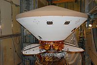 Phoenix er anbragt oven på Delta-raketten på startrampe 17-A på Cape Canaveral.
 Den ene halvdel af raketnæsen er på plads. Den grå kugle nedenunder Phoenix er PAM-D (Payload Assist Module) faststofraketten der giver Phoenix det sidste skub mod Mars.
 Phoenix afprøves grundigt - forgængeren Mars Polar Lander gik tabt i 1999 pga. en mangelfuld afprøvning.
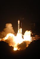 Opsendelsen af Phoenix med en Delta II 7925 raket d. 4. august 2007

 :"Vastitas Borealis - the Phoenix has landed", taget få minutter efter landingen for at se om overfladen kunne bære Phoenix
 Kryoturbation grundet permafrosten (polygoner)
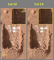 Billedet tv. (15.jun.2008) viser små klumper is nederst tv. i gravesporet, klumperne er fordampet på billedet th. (19.jun.2008)
Noter og referencer
- ^ "NASA Spacecraft Confirms Martian Water, Mission Extended – fra NASA, 31. aug. 2008". Arkiveret fra originalen 18. april 2012. Hentet 1. august 2008.
- ^ Ice Cold Sunrise on Mars, JPL Arkiveret 28. august 2008 hos Wayback Machine (engelsk)
- ^ Mars24 sunclock, NASA (engelsk)
- ^ "Solopgang på Mars, Tycho Brahe Planetarium". Arkiveret fra originalen 21. februar 2021. Hentet 28. august 2008.
Eksterne henvisninger
| Wikinews: Phoenix spacecraft launches towards Mars – relateret nyhedssag på engelsk |
| Wikinews: Canada contributes weather station to NASA Mars mission – relateret nyhedssag på engelsk |
- Phoenix hjemmeside Arkiveret 28. februar 2008 hos Wayback Machine
- Side om Phoenix Arkiveret 23. oktober 2011 hos Wayback Machine fra JPL
- Profil af Phoenix Arkiveret 19. oktober 2015 hos Wayback Machine af NASA's Solar System Exploration
- Liste over indholdet på Phoenix DVDen
- Introduktion til Visions of Mars Projektet fra The Planetary Society
- Video af Phoenix transport til opsendelsesstedet
- Video der beskriver sondens formål
- Video af opsendelsen af Phoenix
- Video med detaljer om Phoenixmissionen Arkiveret 6. januar 2016 hos Wayback Machine
Rumsondemissioner til Mars | ||
|---|---|---|
| Forbiflyvninger |  | |
| Satelitter |
| |
| Landere / Køretøjer |
| |
| Fremtidige missioner |
| |
| Se også |
| |
Fed kursiv indikerer aktive marsmissioner | ||
| Denne artikel kan blive bedre, hvis der indsættes geografiske koordinater Denne artikel omhandler et emne, som har en geografisk lokation. Du kan hjælpe ved at indsætte koordinater i wikidata. |
Medier brugt på denne side
Original Caption Released with NASA Image:

An artist's rendition of the Phoenix Mars probe during landing. The sophisticated landing system on Phoenix allows the spacecraft to touch down within 10 kilometres (6.2 mi) of the targeted landing area. Thrusters are started when the lander is 570 metres (1,870 ft) above the surface. The navigation system is capable of detecting and avoiding hazards on the surface of Mars.

This image shows a polygonal pattern in the ground near NASA's Phoenix Mars Lander, similar in appearance to icy ground in the arctic regions of Earth.
Phoenix was confirmed to have touched down on the Red Planet at 22:53 GMT, 25 May, 2008, in an arctic region called Vastitas Borealis, at 68 degrees north latitude, 234 degrees east longitude.
This is an approximate-colour image taken shortly after landing by the spacecraft's Surface Stereo Imager, inferred from two colour filters, a violet, 450-nanometre filter and an infrared, 750-nanometre filter.
The Phoenix Mission is led by the University of Arizona, Tucson, on behalf of NASA. Project management of the mission is by NASA's Jet Propulsion Laboratory, Pasadena, California. Spacecraft development is by Lockheed Martin Space Systems, Denver.
On Launch Pad 17-A at Cape Canaveral Air Force Station, the Phoenix Mars Lander waits for the fairing installation. Phoenix is targeted for launch on Aug. 3 aboard a Delta II rocket. The fairing is a molded structure that fits flush with the outside surface of the Delta II upper stage booster and forms an aerodynamically smooth nose cone, protecting the spacecraft during launch and ascent. Phoenix will land in icy soils near the north polar, permanent ice cap of Mars and explore the history of the water in these soils and any associated rocks, while monitoring polar climate. Landing on Mars is planned in May 2008 on arctic ground where a mission currently in orbit, Mars Odyssey, has detected high concentrations of ice just beneath the top layer of soil.

NASA's next Mars-bound spacecraft, the Phoenix Mars Lander, was partway through assembly and testing at Lockheed Martin Space Systems, Denver, in September 2006, progressing toward an August 2007 launch from Florida. In this photograph, spacecraft specialists work on the lander after its fan-like circular solar arrays have been spread open for testing. The arrays will be in this configuration when the spacecraft is active on the surface of Mars.
Phoenix will land in icy soils near the north polar permanent ice cap of Mars and explore the history of the water in these soils and any associated rocks, while monitoring polar climate. It will dig into the surface, test scooped-up samples for carbon-bearing compounds and serve as NASA's first exploration of a potential habitat on Mars.
The Delta II 7925 rocket carrying NASA's Phoenix Mars lander lifts off amid billows of smoke from Pad 17A at Cape Canaveral Air Force Station at 5:26 a.m. EDT. Phoenix will land in icy soils near the north polar, permanent ice cap of Mars and explore the history of the water in these soils and any associated rocks, while monitoring polar climate. Landing on Mars is planned in May 2008 on arctic ground where a mission currently in orbit, Mars Odyssey, has detected high concentrations of ice just beneath the top layer of soil.

NASA's Phoenix Mars Lander monitors the atmosphere overhead and reaches out to the soil below in this artist's depiction of the spacecraft fully deployed on the surface of Mars. Phoenix has been assembled and tested for launch in August 2007 from Cape Canaveral Air Force Station, Fla., and for landing in May or June 2008 on an arctic plain of far-northern Mars. The mission responds to evidence returned from NASA's Mars Odyssey orbiter in 2002 indicating that most high-latitude areas on Mars have frozen water mixed with soil within arm's reach of the surface. Phoenix will use a robotic arm to dig down to the expected icy layer. It will analyze scooped-up samples of the soil and ice for factors that will help scientists evaluate whether the subsurface environment at the site ever was, or may still be, a favorable habitat for microbial life. The instruments on Phoenix will also gather information to advance understanding about the history of the water in the icy layer. A weather station on the lander will conduct the first study Martian arctic weather from ground level. The vertical green line in this illustration shows how the weather station on Phoenix will use a laser beam from a lidar instrument to monitor dust and clouds in the atmosphere. The dark "wings" to either side of the lander's main body are solar panels for providing electric power. The Phoenix mission is led by Principal Investigator Peter H. Smith of the University of Arizona, Tucson, with project management at NASA's Jet Propulsion Laboratory and development partnership with Lockheed Martin Space Systems, Denver. International contributions for Phoenix are provided by the Canadian Space Agency, the University of Neuchatel (Switzerland), the University of Copenhagen (Denmark), the Max Planck Institute (Germany) and the Finnish Meteorological institute. JPL is a division of the California Institute of Technology in Pasadena.

This image of the Phoenix landing gear was acquired at the spacecraft's landing site on day 1 of the mission on the surface of Mars, or Sol 0, after the May 25, 2008, landing. The surface stereo imager left acquired this image at 17:07:41 local solar time. The camera pointing was elevation -63.4431 degrees and azimuth 39.9232 degrees.

These color images were acquired by NASA's Phoenix Mars Lander's Surface Stereo Imager on the 21st and 25th days of the mission, or Sols 20 and 24 (June 15 and 19, 2008).
These images show sublimation of ice in the trench informally called "Dodo-Goldilocks" over the course of four days.
In the lower left corner of the left image, a group of lumps is visible. In the right image, the lumps have disappeared, similar to the process of evaporation.