Pardubice (region)
| Regionen Pardubice Pardubický kraj | |||||
|---|---|---|---|---|---|
| |||||
 | |||||
| Overblik | |||||
| Land | |||||
| Demografi | |||||
| Indbyggertal | 505.584 (2005) | ||||
| - Areal | 4.519 km² | ||||
| - Befolkningstæthed | 112 pr. km² | ||||
| Andet | |||||
| Højde m.o.h. | 202 - 1.424 m | ||||
| Hjemmeside | www.pardubickykraj.cz | ||||
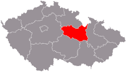
Pardubice (tjekkisk: Pardubický kraj) er en administrativ region i Tjekkiet. Regionen ligger i det østlige Bøhmen, men omfatter også dele af det historiske Mähren. Administrationsenter er byen er Pardubice, der også er regionens største by. Regionen består af 4 distrikter med i alt 453 kommuner. Den har en udstrækning på mellem 39 – 64 km i nord-sydlig retning, og op til 101 km i øst -vestlig retning.
Distrikter
| Statistiske oplysninger 20025 | ||||
|---|---|---|---|---|
 | ||||
| Distrikter | Areal/km² | Indbyggere | Gennemsnitsalder | Kommuner |
| Chrudim | 1.030 | 104.748 | 39,0 | 113 |
| Pardubice | 889 | 160.251 | 40,0 | 115 |
| Svitavy | 1.335 | 101.832 | 38,4 | 113 |
| Ústí nad Orlicí | 1.265 | 138.753 | 38,3 | 112 |
Andel af Bruttonationalprodukt (2001): 4,2 %, Arbejdsløshed (2002): 8,7 %
Største byer
| By | Indbyggere (31. december 2005) |
|---|---|
| Pardubice | 88.260 |
| Chrudim | 23.385 |
| Svitavy | 17.248 |
| Česká Třebová | 16.533 |
| Ústí nad Orlicí | 14.918 |
| Vysoké Mýto | 12.432 |
| Moravská Třebová | 11.251 |
| Hlinsko | 10.295 |
| Litomyšl | 10.118 |
| Lanškroun | 9.807 |
| Polička | 9.029 |
| Choceň | 8.953 |
| Přelouč | 8.467 |
| Holice | 6.298 |
| Letohrad | 6.202 |
| Žamberk | 6.017 |
| Skuteč | 5.304 |
Galleri
- Chrudim
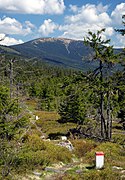
- Kralický Sněžník
- Kunětická hora slot
- Lanškroun rådhus
- Litomyšl slot
- Moravská Třebová
- Nové Hrady slot
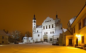
- Pardubice slot
- Polička
- Slatiňany slot
- Veselý Kopec
- Slotsruinen Lichnice i Jernbjergene
Koordinater: 49°54′N 16°12′Ø / 49.9°N 16.2°Ø
|
Medier brugt på denne side
Polička, Svitavy District, Czech Republic: St. Mary's column
Forfatter/Opretter: palickap, Licens: CC BY 3.0
Moravská Třebová in Svitavy District, Czech Republic. Masaryk-square and town hall.
Forfatter/Opretter: Straková Jiřina, Licens: CC0
Renesační radnice na náměstí J. M. Marků v Lanškrouně.
Map of the districts of Pardubice region of the Czech Republic. Created by Rarelibra 15:14, 2 January 2007 (UTC) for public domain use, using MapInfo Professional v8.5 and various mapping resources.
Forfatter/Opretter: Karelj, Licens: CC BY-SA 3.0
Castle Kunětice Mountain Castle on hill Kunětice Mountain from air, eastern Bohemia, Czech Republic
Lichnice v lednu
Forfatter/Opretter: cs:User:Zp (autor:Zp), Licens: CC BY-SA 3.0
Archdecanal church of Assumption in Chrudim, Czech Republic.
Slatiňany Castle, Chrudim District, Czech Republic. A view from the east.
Forfatter/Opretter: Mardoko, Licens: CC BY-SA 3.0
This is a photo of a cultural monument of the Czech Republic,
number:
Forfatter/Opretter: Czcharlie, Licens: CC BY-SA 3.0
This is a photo of a cultural monument of the Czech Republic,
number:
Forfatter/Opretter: Sokoljan, Licens: CC BY-SA 3.0
Litomyšl, Castle from SW
Forfatter/Opretter: Marek Stránský, Licens: CC BY 3.0
Kralicky Sneznik mountain
Flag of Pardubice Region


