Otradnoje (Leningrad oblast)
| Otradnoje Отрадное | |||||
|---|---|---|---|---|---|
| |||||
 | |||||
| Overblik | |||||
| Land | |||||
| Føderalt distrikt | Nordvestlige | ||||
| Oblast | Leningrad | ||||
| Rajon | Kirovsk | ||||
| Grundlagt | 1708 | ||||
| Postnr. | 188330, 188331 | ||||
| Telefonkode | 81362 | ||||
| Nummerpladebogstav(er) | 47 | ||||
| UN/LOCODE | RUODY | ||||
| Demografi | |||||
| Indbyggere | 25.258 (2024) | ||||
| - Areal | 70,1 km² | ||||
| - Befolkningstæthed | 360 pr. km² | ||||
| Andet | |||||
| Tidszone | UTC+3 | ||||
| Højde m.o.h. | 17 m | ||||
| Hjemmeside | www.otradnoe-na-neve.ru | ||||
| Oversigtskort | |||||
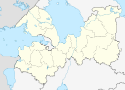
| Leningrad oblasts beliggenhed i Rusland | |||||
(c) Karte: NordNordWest, Lizenz: Creative Commons by-sa-3.0 de Otradnoje | |||||
Otradnoje (russisk: Отрадное) er en by i den nordvestlige del af den europæiske del af Rusland.
Otradnoje ligger ca. 40 kilometer øst for Sankt Petersborg, hvor floden Tosna løber ud floden Neva. Byen har et indbyggertal på 25.258 (2024) indbyggere og ligger i Kirovsk rajon i Leningrad oblast.
Referencer
Eksterne henvisninger
| Spire |
Medier brugt på denne side
Flag-map of Russia
Позиционная карта Ленинградской области
- Проекция — равноугольная.
- Стандартная параллель — 60°00′00″С
- Параметры шаблона (координаты краёв):
|top    = 61.5
|bottom = 58.2
|left   = 26.7
|right  = 35.9
Forfatter/Opretter: Stasyan117, Licens: CC BY-SA 4.0
Ленинградская область на карте России
Церковь святого Иоанна Милостивого (Иоанновский храм) - действующий православный храм в городе Отрадное Ленинградской области.
Флаг города Отрадное Кировского района Ленинградской области
Otradnoe (Leningrad oblast), coat of arms
(c) Karte: NordNordWest, Lizenz: Creative Commons by-sa-3.0 de
Location map of European Russia.
- Projection: Lambert azimuthal equal-area projection.
- Area of interest:
- N: 75.0° N
- S: 40.0° N
- W: 25.0° E
- E: 60.0° E
- Projection center:
- NS: 57.5° N
- WE: 42.5° E
- GMT projection: -JA42.5/57.5/20c
- GMT region: -R25.450860698632475/38.37411418933942/86.79037939442836/70.79910933370674r
- GMT region for grdcut: -R-2.0/38.0/87.0/76.0r
- Made with Natural Earth. Free vector and raster map data @ naturalearthdata.com.


