Osaka
| Osaka 大阪市 | |||||
|---|---|---|---|---|---|
| |||||
 | |||||
| Overblik | |||||
| Land | |||||
| Borgmester | Ichirō Matsui | ||||
| Region | Kansai | ||||
| Grundlagt | 1. april 1889 | ||||
| Postnr. | 530-0002–559-0034 | ||||
| Telefonkode | 6 | ||||
| Nummerpladebogstav(er) | Naniwa | ||||
| UN/LOCODE | JPOSA | ||||
| Demografi | |||||
| Indbyggere | 2.751.862 (2021)[1] | ||||
| - Areal | 223 km² | ||||
| - Befolkningstæthed | 12.340 pr. km² | ||||
| Osaka-Kobe-Kyoto metroområde | 19.302.746 (2015) | ||||
| Andet | |||||
| Tidszone | UTC+9 | ||||
| Højde m.o.h. | 20 m | ||||
| Hjemmeside | www.city.osaka.lg.jp | ||||
| Oversigtskort | |||||
Osaka (大阪 Ōsaka) ![]() listen ? er en by med 2.751.862(2021)[1] indbyggere i Japans Kansai-region på øen Honshū. Byen er hovedstad i Osaka-præfekturet og den største by i Keihanshinområdet, der bl.a. består af byerne Kyoto, Osaka og Kobe og udgør Osakas byområde. Osaka er den tredjestørste by i Japan efter Tokyo og Yokohama. Osaka-Kobe-Kyoto metroområde (Keihanshin) har 19.302.746 (2015)
listen ? er en by med 2.751.862(2021)[1] indbyggere i Japans Kansai-region på øen Honshū. Byen er hovedstad i Osaka-præfekturet og den største by i Keihanshinområdet, der bl.a. består af byerne Kyoto, Osaka og Kobe og udgør Osakas byområde. Osaka er den tredjestørste by i Japan efter Tokyo og Yokohama. Osaka-Kobe-Kyoto metroområde (Keihanshin) har 19.302.746 (2015) ![]() indbyggere og er Japans næststørste efter Stortokyo og blandt verdens megabyer.[2] Byområdets BNP er det næststørste i Japan og verdens 7. største.
indbyggere og er Japans næststørste efter Stortokyo og blandt verdens megabyer.[2] Byområdets BNP er det næststørste i Japan og verdens 7. største.
Geografisk ligger Osaka ved Yodo Flodens udmunding i Osaka Bugt.
Historisk set har det været Japans handelscentrum.[3] Osaka blev kaldt for "nationens køkken" (天下の台所 tenka no daidokoro) i Edo-perioden, fordi byen var centrum for handel med ris og hjemsted for verdens første future-marked.[4][5][6]
Notable bysbørn
Videre læsning
- Gerstle, C. Andrew. Kabuki Heroes on the Osaka Stage 1780-1830 (2005).
- Hanes, Jeffrey. The City as Subject: Seki Hajime and the Reinvention of Modern Osaka (2002) online edition Arkiveret 13. maj 2012 hos Wayback Machine
- Hauser, William B. "Osaka: a Commercial City in Tokugawa Japan." Urbanism past and Present 1977-1978 (5): 23-36.
- Hein, Carola, et al. Rebuilding Urban Japan after 1945. (2003). 274 pp.
- Hotta, Chisato. "The Construction of the Korean Community in Osaka between 1920 and 1945: A Cross-Cultural Perspective." PhD dissertation U. of Chicago 2005. 498 pp. DAI 2005 65(12): 4680-A. DA3158708 Fulltext: ProQuest Dissertations & Theses
- Lockyer, Angus. "The Logic of Spectacle C. 1970," Art History, Sept 2007, Vol. 30 Issue 4, p571-589, on the international exposition held in 1970
- McClain, James L. and Wakita, Osamu, eds. Osaka: The Merchants' Capital of Early Modern Japan. (1999). 295 pp. online edition Arkiveret 13. maj 2012 hos Wayback Machine
- Michelin Red Guide Kyoto Osaka Kobe 2011 (2011)
- Najita, Tetsuo. Visions of Virtue in Tokugawa Japan: The Kaitokudo Merchant Academy of Osaka. (1987). 334 pp. online edition Arkiveret 13. maj 2012 hos Wayback Machine
- Rimmer, Peter J. "Japan's World Cities: Tokyo, Osaka, Nagoya or Tokaido Megalopolis?" Development and Change 1986 17(1): 121-157. Issn: 0012-155x
- Ropke, Ian Martin. Historical Dictionary of Osaka and Kyoto. (1999) 273pp
- Ruble, Blair A. Second Metropolis: Pragmatic Pluralism in Gilded Age Chicago, Silver Age Moscow, and Meiji Osaka. (2001). 464 pp.
- Torrance, Richard. "Literacy and Literature in Osaka, 1890-1940," The Journal of Japanese Studies 31#1 (Winter 2005), pp. 27–60 in Project Muse
Referencer
- ^ a b 大阪府/大阪府の毎月推計人口, hentet 2. april 2021 (fra Wikidata).
- ^ "Table 92, Final Report of The 2000 Population Census". E-stat.go.jp. Hentet 2010-05-05.
- ^ "Population Census: I Daytime Population". Statistics Bureau, Ministry of Internal Affairs and Communications. 2002-03-29. Hentet 2007-03-28.
- ^ Aprodicio A. Laquian (2005). Beyond metropolis: the planning and governance of Asia's mega-urban regions. Washington, D.C: Woodrow Wilson Center Press. s. 27. ISBN 0-8018-8176-5.
- ^ edited by James L. McClain and Wakita Osamu (1999). Osaka, the merchants' capital of early modern Japan. Ithaca, N.Y: Cornell University Press. s. 67. ISBN 0-8014-3630-3.
{{cite book}}:|author=har et generisk navn (hjælp) - ^ Robert C. Hsu (1999). The MIT encyclopedia of the Japanese economy. Cambridge, Mass: MIT Press. s. 327. ISBN 0-262-08280-2.
Eksterne henvisninger
- Official Osaka Prefectural Government homepage Arkiveret 26. november 2012 hos Wayback Machine
- Official City of Osaka homepage
- Official Osaka Tourist Guide
- Osaka Arkiveret 18. marts 2015 hos Wayback Machine Guide with interactive map
| Spire |
|
Medier brugt på denne side
Forfatter/Opretter: Maximilian Dörrbecker (Chumwa), Licens: CC BY-SA 3.0
Location map of Japan
Equirectangular projection.
Geographic limits to locate objects in the main map with the main islands:
- N: 45°51'37" N (45.86°N)
- S: 30°01'13" N (30.02°N)
- W: 128°14'24" E (128.24°E)
- E: 149°16'13" E (149.27°E)
Geographic limits to locate objects in the side map with the Ryukyu Islands:
- N: 39°32'25" N (39.54°N)
- S: 23°42'36" N (23.71°N)
- W: 110°25'49" E (110.43°E)
- E: 131°26'25" E (131.44°E)
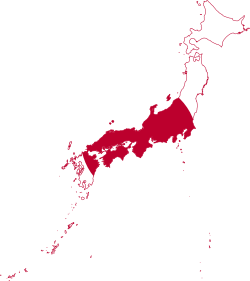
Flag-map of Japan
Emblem of Osaka, Osaka
Flag of Osaka, Osaka
Forfatter/Opretter: Kyoww, Licens: CC BY-SA 3.0
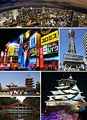
From top left: Night view from Umeda Sky Building, Dotonbori, Tsutenkaku, Shitennoji Temple, Sumiyoshi-taisha Shrine and Osaka Castle.


