Nyspanien
Nyspanien Virreinato de Nueva España | |||||||||||||||||
|---|---|---|---|---|---|---|---|---|---|---|---|---|---|---|---|---|---|
| Spansk koloni | |||||||||||||||||
| 1535–1821 | |||||||||||||||||
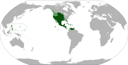
 Kort over de tidligere territorier tilhørende Vicekongedømmet Nyspanien | |||||||||||||||||
| Hovedstad | Mexico City | ||||||||||||||||
| Sprog | Officielt: Spansk (de facto), Nahuatl (de facto) Almindelige: Mayasprog, Tagalog | ||||||||||||||||
| Religion | Katolicisme | ||||||||||||||||
| Regeringsform | Monarki | ||||||||||||||||
| Konge af Spanien | |||||||||||||||||
• 1535–56 | Karl I | ||||||||||||||||
• 1813–21 | Ferdinand VII | ||||||||||||||||
| Vicekonge | |||||||||||||||||
• 1535–50 | Antonio de Mendoza | ||||||||||||||||
• 1550-64 | Luis de Velasco | ||||||||||||||||
• 1673-80 | Payo Enríquez de Rivera | ||||||||||||||||
• Juli–september 1821 | Juan O'Donojú | ||||||||||||||||
| Historisk periode | Kolonitiden | ||||||||||||||||
• Erobringen af Mexico | 1519–21 | ||||||||||||||||
• Vicekongedømmet oprettet | 1535 | ||||||||||||||||
| 27. maj 1717 | |||||||||||||||||
• San Ildefonso Traktat | 1. oktober 1800 | ||||||||||||||||
• Grito de Dolores | 1810 | ||||||||||||||||
• Adams-Onis traktaten | 1819 | ||||||||||||||||
• Mexikansk og Mellemamerikansk uafhængighed | 1821 | ||||||||||||||||
| Befolkning | |||||||||||||||||
• Anslået 1519 | 20.000.000 | ||||||||||||||||
• Anslået 1810 | 5.000.000 til 6500000 | ||||||||||||||||
| Valuta | Peso | ||||||||||||||||
| |||||||||||||||||
Nyspanien (på spansk Nueva España) var navnet på det nye spanske koloniale territorium i Nordamerika fra omkring 1521 til 1821. Hovedstaden i Nyspanien var Mexico City. Nyspanien blev fra 1535 regeret af en vicekonge udnævnt af kongen af Spanien. Nyspaniens territorium dækkede omtrent hele det nuværende Mellemamerika, Caribien, Mexico, de vestlige 2/3 af det USA samt Filippinerne. Derudover gjorde Spanien krav på land længere mod nord med upræcist definerede grænser.

Medier brugt på denne side
Flag placeholder. See also Category:Flag placeholders and Coats of arms of None.svg.
The Rhodes Colossus: Caricature of Cecil John Rhodes, after he announced plans for a telegraph line and railroad from Cape Town to Cairo.
Forfatter/Opretter: Eddo, Licens: CC BY-SA 3.0
Anachronistic map of New Spain, built from Image:New_Spain.png by myself and released on multi-licence (GFDL and CC-BY 2.5). This image includes the territory of Louisiana, annexed to the Spanish Empire in 1763 after the Seven Years' War, but then given back to France in 1801. The areas in light green were territories claimed by Spain.
Forfatter/Opretter: previous version User:Ignaciogavira ; current version HansenBCN, designs from SanchoPanzaXXI, Licens: CC BY-SA 3.0
Flag of Spain (1785-1873 and 1875-1931)
Digital reproduction of the Star Spangled Banner Flag, the 15-star and 15-stripe U.S. garrison flag which flew over Fort McHenry following the Battle of Baltimore in the War of 1812. Seeing the flag during the battle, and again the following morning, inspired Francis Scott Key's song The Star-Spangled Banner, now the U.S. national anthem. During the battle a smaller "storm flag" was flown; it was replaced by this larger flag early the next morning, which is the flag Key saw then. This larger flag is now displayed at the National Museum of American History in Washington, D.C. For several decades it remained in the family of Fort McHenry's commanding officer, before being given to the Smithsonian in 1912. The family cut pieces out of the flag from time to time as gifts.
The original flag was 42 feet long and 30 feet high, with each stripe being about two feet, and the stars being about two feet in diameter. It was made by Mary Young Pickersgill and her assistants. More info on the original dimensions here. The stars seem to mostly point to the side, except for one (the bottom right) which points down. One star has been cut out of the actual flag, so I'm guessing that originally pointed to the side as well (Fort McHenry flies a flag (File:Ft mchenry 15starflag.jpg) with a similar star pattern, but it looks like they are all to the side, and the other dimensions look similar to a modern flag). I guesstimated other dimensions and star positions based on File:Star-Spangled-Banner-1908-1919.jpg; the union (blue area) looks to be about 19 feet wide. The star rows look to be evenly distributed; i.e. the distance between the top/bottom edges and the center of a star row looks to be about the same as the distance between two (centers of) rows. Not so left-to-right; they are pretty close to the right edge and even closer to the hoist side. Also available here, page 12.Forfatter/Opretter: Ningyou., Licens: CC BY-SA 3.0
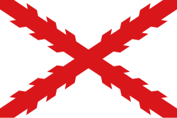
Flag with the cross of Burgundy (saltire). Also named Cross of Burgundy flag. It was used in the Catholic Monarchy and in its viceroyalties such as New Spain and Peru. It was also used by Spain as a military or king's prosonal flag. Used by the Carlist movement.
Forfatter/Opretter: Ipankonin, Licens: CC BY-SA 3.0
Full armorial achievement of Charles I of Spain
US Flag with 23 stars. In use 4 July 1820–4 July 1822. Created by jacobolus using Adobe Illustrator, and released into the public domain.


