Nyiragongo
Koordinater: 1°31′S 29°15′Ø / 1.517°S 29.250°Ø

.jpg)


Nyiragongo er en aktiv vulkan i Demokratiske Republik Congo (tidligere Zaire) tæt ved byen Goma. Den ligger i Virunga nationalpark 20 km nord for Kivusøen i Riftdalen.
Bjerget er en stratovulkan og måler 3.470 moh. Nyiragongo er kendt for at have en stort set permanent lavasø.
Nyiragongos udbrud er uforudseelige og den betragtes som en af de farligste vulkaner i Afrika.
Nylige udbrud
2021
Den 22. maj 2021 begyndte Nyiragongo at gå i udbrud med lavastrømme ind i Goma. Den 25. maj døde 32 mennesker, 750 andre blev såret og flere tusinde fortrængt. Udbruddet efterlod et spor af 1.000 ødelagte hjem.[1]
2002
Vulkanen havde et kraftig udbrud i januar 2002. En 200-1.000 meter bred lavastrøm nåede provinshovedstaden Goma, dækkede den nordlige del af byens internationale flyveplads, og løb ud i Kivusøen. 400.000 mennesker blev evakueret, men alligevel omkom 45 personer af kvælning eller under sammenstyrtede bygninger. 4.500 bygninger blev ødelagt[2]
Efter udbruddet var der flere større jordskælv i omtrent tre måneder, som førte til skader på bygninger.
Nabobjerget Nyamuragira havde udbrud seks måneder senere. Nyiragongo er fortsat aktiv, med en ny lavasø dannet i krateret.
1977
I 1977 var lavasøen steget så højt at toppen af vulkanen styrtede sammen, hvilket førte til en kraftig strøm af lava. Dette medførte store ødelæggelser og flere mennesker omkom.
Eksterne kilder/henvisninger
- ^ A Volcano Erupted Without Warning. Now, Scientists Know Why. New York Times 2022
- ^ Satellitbillede med sammenligning af området i 2001 og 2003 (Webside ikke længere tilgængelig)
Medier brugt på denne side
Forfatter/Opretter: Cai Tjeenk Willink (Caitjeenk), Licens: CC BY-SA 3.0
Lava Lake of the Nyiragongo Volcano in Virunga National Park in Eastern DRC
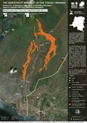
28 May map of lava flow and tremors from the Mount Nyiragongo eruption in relation to Goma, DRC from UNITAR
(c) MONUSCO/Neil Wetmore, CC BY-SA 2.0
An aerial view of the towering volcanic peak of Mount Nyiragongo.
Forfatter/Opretter: MONUSCO Photos, Licens: CC BY-SA 2.0
Goma, North Kivu, DRC: The Nyirangongo volcano, one of the most active in the Great Lakes region, erupted on Saturday, May 22, causing the displacement of populations who feared for their safety. MONUSCO helicopters carried out reconnaissance flights over the crater and brought in specialists to monitor and advice on the state of the volcano after the eruption.
MONUSCO has remained actively engaged alongside the Congolese population and authorities to deal with this situation. Its civil and military engineering team reopened the Goma-Rutshuru-Butembo road section, which is vital for the supply of food to the population of GomaPeacekeepers in Goma also provided healthcare, distributing food and water to some displaced persons. MONUSCO has also remained present and continues to hold its positions in the city. Its Indian peacekeepers are patrolling 24/7 on the different routes to monitor and prevent theft-related incidents and lootings in abandoned areas.MONUSCO peacekeepers from China are working to improve traffic on the national road n° 2, between Goma, in North-Kivu, and Bukavu, in South-Kivu. making it possible for thousands of vehicles to reach Bukavu and seek refuge against the latest natural disaster which hit the city of Goma.
Depiction of the Nyiragongo and Nyamuragira volcanoes, based on data from the Shuttle Radar Topography Mission and Landsat. Vertical scale exaggerated (1.5x)