Nottinghamshire
Denne artikel eller dette afsnit er forældet. Teksten er helt eller delvist kopieret fra et gammelt opslagsværk (Salmonsens Konversationsleksikon), og det er rimeligt at formode, at der findes nyere viden om emnet. |
| Nottinghamshire | |
|---|---|
 | |
 | |
| Geografi | |
| Status | Ceremonielt og non-metropolitan county |
| Region | East Midlands |
| Areal - Samlet | km² |
| Admin.by | West Bridgford |
| ISO 3166-2 | GB-NTT |
| ONS-kode | 37 |
| NUTS 3 | UKF15/16 |
| Demografi | |
| Indbyggere - Total () - tæthed | /km² |
| Etnisk fordeling | |
| Politik | |
| Intet county council | |
| Parlamentsmedlemmer | |
| Distrikter | |

| |
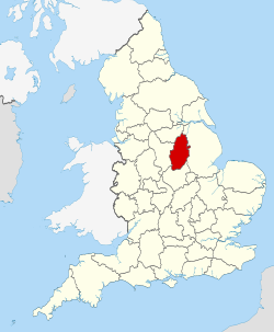
Nottinghamshire (forkortes Notts) er et engelsk ceremonielt grevskab i regionen Øst-Midlands. Grevskabet grænser op mod South Yorkshire, Lincolnshire, Leicestershire og Derbyshire.
West Bridgford
Nottingham har tidligere været administrationsby (County town), men nu er Nottinghamshire County Council flyttet til forstaden West Bridgford, der ligger på den modsatte side af floden Trent. City Ground i West Bridgford blev hjemmebane for fodboldklubben Nottingham Forest F.C. i 1898. West Bridgford ligger i distriktet Rushcliffe lige syd for Nottingham.
Syv distrikter og én selvstyrende kommune
Det administrative grevskab er delt i syv distrikter. City of Nottingham blev en selvstyrende kommune i 1998, men er stadig en del af det ceremonielle grevskab.
Byer
- Arnold
- Beeston
- Bingham
- Bulwell
- Carlton
- Cotgrave
- Eastwood
- Harworth Bircotes
- Hucknall
- Kimberley
- Kirkby-in-Ashfield
- Mansfield
- Mansfield Woodhouse
- Netherfield
- Newark-on-Trent
- Nottingham
- Ollerton
- Retford
- Stapleford
- Southwell
- Sutton-in-Ashfield
- Tuxford
- Warsop
- West Bridgford
- Worksop
Seværdigheder
- Attenborough Nature Reserve
- Beauvale Priory
- Beth Shalom Holocaust Centre
- Clumber Park National Trust
- Creswell Crags
- D. H. Lawrence Birthplace Museum
- Felley Priory
- The Harley Gallery
- Greens windmill and sicence center
- Hawton Church
- Mansfield Museum
- Mr Straw's House National Trust
- Newark Air Museum
- Newark Castle, Nottinghamshire
- Newstead Abbey
- Nottingham Castle
- Papplewick Pumping Station
- Rufford Country Park
- Rushcliffe Country Park
- Sherwood Forest
- Sherwood Observatory
- Sherwood Pines Forest Park
- Silverhill, Nottinghamshire
- Southwell Minster
- St Mary's Church, Edwinstowe
- Sundown Adventureland
- Teversal
- The Royal Lancers and Nottinghamshire Yeomanry Museum
- The Workhouse, Southwell National Trust
- Thoresby Hall Park
- Wheelgate Park
- Welbeck Abbey
- Wollaton Hall
- Wollaton Park
- Ye Olde Trip To Jerusalem
Eksterne henvisninger
- Nottinghamshire i Salmonsens Konversationsleksikon (2. udgave, 1924)
Se også
53°10′N 1°0′V / 53.167°N 1.000°V
| Denne artikel om lokaliteten Nottinghamshire kan blive bedre, hvis der indsættes et (bedre) billede. Du kan hjælpe ved at afsøge Wikimedia Commons for et passende billede eller lægge et op på Wikimedia Commons med en af de tilladte licenser og indsætte det i artiklen. |
| Spire Denne artikel om britisk geografi er en spire som bør udbygges. Du er velkommen til at hjælpe Wikipedia ved at udvide den. |
Medier brugt på denne side
Forfatter/Opretter: David Vignoni (globe, clock face/ring), Anomie (clock hands), David Göthberg (making the clock red, shadows). Anomie and David G (putting all the parts together)., Licens: LGPL
Globe with clock to represent a "current event"
Forfatter/Opretter:
The original uploader was Yzmo at engelsk Wikipedia.
Later versions were uploaded by Tene at en.wikipedia., Licens: LGPLThis image is combined from the following two images.
A map of the United Kingdom, overlaid with the UK flag.
Flag of Nottinghamshire
Forfatter/Opretter: Nilfanion, Licens: CC BY-SA 3.0
Location of the ceremonial county of Nottinghamshire within England.
Nottinghamshire districts map (numbered) For use on the w:Nottinghamshire Wikipedia page.


