North Cascades National Park
| North Cascades National Park | |
|---|---|
 Magic Mountain sett fra Sahale Arm, nord for Cascade Pass. Foto: Daniel Hershman | |
| Ligger i | USA |
| Område | |
| Nærmeste by | Bellingham |
| Areal | 2.768 km² |
| Oprettet | 2. oktober 1968 |
| Årligt besøgstal | 19.534 (2006) |
| Oversigtskort | |
North Cascades National Park er en nationalpark i delstaten Washington i USA. Parken blev etableret 2. oktober 1968 og havde næsten 20.000 besøgende i 2007. Næsten 93 % af parken blev yderligere beskyttet som uberørt natur via Washington Park Wilderness Act fra 1988[1].
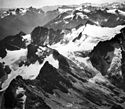
De vigtigste naturattraktioner i nationalparken er gletcherne. I 1971 havde parken 318 gletchere med et samlet areal på 117 km² og var dermed den parken med flest gletchere af alle amerikanske parker som ligger udenfor Alaska. Alle gletchere i parken havde stor afsmeltning mellem 1980 og 2005 og hastigheden på issmeltningen øger. Parken omfatter dele af bjergkæden North Cascades .
Nationalparken er også kendt for sit dyreliv. Vildmarksområderne i parken er et naturlig tilholdssted for dyr som ulv, los, elg, jærv og mange andre sjældne og truede dyrearter. Det er været flere observationer af sortbjørn, og også flere andre pattedyr, amfibier og krybdyr er registreret i parken.
Det er ekstrem variation i klima og landskab i parken og dette afspejles i det varierede planteliv. Parken indeholder også cirka 236 km² med gammel skov som i enkelte tilfælde er flere hundrede år gamle.
Nationalparken har fritidsområder ved søerne Ross Lake og Lake Chelan. Der er populære vandre- og klatreområder ved Cascade Pass, Mount Shuksan, Mount Triumph og Eldorado Peak.
Se også
Eksterne kilder/henvisninger
Koordinater: 48°42′N 121°12′V / 48.70°N 121.20°V
|
Medier brugt på denne side
Forfatter/Opretter: NordNordWest, Licens: CC BY-SA 3.0
Location map of the United States ("lower 48")
Logo of the United States National Park Service, an agency of the United States Department of the Interior. This version is shaded to look as if it has been carved out of wood or rock. The elements on the logo represent the major facets of the national park system. The Sequoia tree and bison represent vegetation and wildlife, the mountains and water represent scenic and recreational values, and the arrowhead represents historical and archeological values. The bison is also the symbol of the Department of the Interior. The logo became the official logo on July 20, 1951, replacing the previous emblem of a Sequoia cone, and has been used ever since. The design was slightly updated in 2001, and a few different renderings are used today. For more information, see here and here.[dead link]
Forfatter/Opretter: Daniel Hershman, Licens: CC BY 2.0
Pelton Peak, Yawning Glacier and Magic Mountain (left to right) from Sahale Arm north of Cascade Pass, North Cascades National Park, Washington, United States
Cascade pass
Ladder Creek and Neve Glaciers, Snowfield Peak, in North Cascades National Park. This scene displays the rugged nature of the North Cascades where glacierized peaks rise abruptly from heavily timbered valleys that are less than 1,000 m above sea level. The Cascade divide is crossed by trail at Park Creek Pass (altitude 1,845 m) top left; Goode Mountain (altitude 2,800 m) is to the left, and Buckner Mountain (altitude 2,780 m) with Boston Glacier (7 square km in area) is to the right of the pass. Timberline is at about 1,860 m. Skagit and Whatcom Counties, Washington. ca. 1966. (Aerial view) Published as figure 4 in U. S. Geological Survey. Professional paper 715-A. 1971.
Pinnacle Peak (bottom left) and Paul Bunyans Stump (bottom left center) with Colonial Glacier behind and left; Snowfield Peak (upper right center middle distance) with Neve Glacier descending past the center to the left and Ladder Creek Glacier descending from the center toward the lower right.
View direction: 150°
Image file: http://libraryphoto.cr.usgs.gov/htmllib/btch453/btch453j/btch453z/mmf00003.jpgMap of North Cascades National Park


