Newry
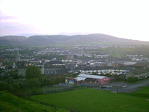
Newry (irsk: Iúr Cinn Trá) er en by i det sydlige Nordirland, med et indbyggertal (pr. 2001) på cirka 27.000. Byen ligger i distriktet Newry and Mourne, 60 kilometer sydvest for hovedstaden Belfast.
Koordinater: 54°10′N 6°21′V / 54.167°N 6.350°V
| Spire Denne artikel om britisk geografi er en spire som bør udbygges. Du er velkommen til at hjælpe Wikipedia ved at udvide den. |
|
Medier brugt på denne side
A map of the United Kingdom, overlaid with the UK flag.
Forfatter/Opretter: NordNordWest, Licens: CC BY-SA 3.0
Location map of Ireland
Forfatter/Opretter: The original uploader was Cmcgrath62 at engelsk Wikipedia., Licens: CC BY 2.5
A view over Newry from the Windmill road area showing the spires of several churches, taken close to the city centre. The Cathedral is visible to the right of centre, while the dominican church is near the centre of the picture, with Saint Mary's to the far left. Camlough mountain is clearly visible. (Isn't Newry in Armagh, not Down?)


