New Georgia Sound
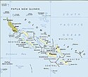
New Georgia Sound er et vandområde, som ligger omtrent midt mellem Salomonøerne. Sundet afgrænses af Choiseul, Santa Isabel og Floridaøerne mod nord, og af Vella Lavella, Kolombangara, New Georgia og Russell-øerne mod syd. Bougainville og Guadalcanal udgør henholdsvis den vestlige og den østlige ende af sundet.
Sundet udgør en af de tre vigtigste ruter for handelsskibe gennem Salomonøerne. Ruterne er Bougainville Strædet og Indispensable Strædet som forbinder Stillehavet, Salomonhavet og Koralhavet og Manning Strædet, som forbinder Stillehavet med New Georgia Sundet.[1][Note 1]
Under Stillehavskrigen var sundet kendt som "the Slot" (sprækken) af Allierede soldater på grund af dens geografiske form og antallet af krigsskibe, som krydsede det. Den japanske flådes indsats for at forsyne garnisonen på Guadalcanal blev kaldt Tokyo Express. Mange søslag blev udkæmpet i og omkring sundet i 1942 og 1943, mellem Kejserriget Japans flåde og de allierede styrker i United States Navy, Royal Australian Navy, og Royal New Zealand Navy.
Vulkanen Savo Island, nordvest for Guadalcanal, er den eneste betydelige ø i sundet.
Noter og henvisninger
- Noter
- ^ Captain Edward Manning sailed Pitt through the strait in 1792, on his way to Bengal after having delivered convicts to Port Jackson, New South Wales.
- Henvisninger
Se også
Koordinater: 8°16′S 158°29′Ø / 8.26°S 158.48°Ø
Medier brugt på denne side
Forfatter/Opretter: This map's source is here, with the uploader's modifications, and the GMT homepage says that the tools are released under the GNU General Public License., Licens: CC BY-SA 3.0
Choiseul in the Solomon Islands and neighbouring islands.
Solomon Islands map, modified and cropped from PCL map collection Courtesy of the University of Texas Libraries, The University of Texas at Austin.
According to the University of Texas, "most of the maps scanned by the University of Texas Libraries and served from this web site are in the public domain. No permissions are needed to copy them. You may download them and use them as you wish. A few maps are copyrighted, and are clearly marked as such.". As the image, when downloaded from here was no tagged, the map is PD.
For a small map of the Solomon Islands, see: Image:SolomonIslandsMap.png
Note that provincial borders are pre-1995; Rennell and Bellona has separated from Central Province, and Choiseul Province has separated from Western Province.
Originally uploaded to En-Wikipedia by Darwinek on 13:39, 29 December 2004.


