Neunkirchen am Brand
| Neunkirchen a.Brand | |
 | |
| Våben | Beliggenhed |
 |  (c) Karte: NordNordWest, Lizenz: Creative Commons by-sa-3.0 de |
| Administration | |
| Land | |
|---|---|
| Delstat | Bayern |
| Admin. region | Oberfranken |
| Kreis | Forchheim |
| Borgmester | Heinz Richter (FWG) |
| Statistiske data | |
| Areal | 26,37 km² |
| Højde | 317 m |
| Indbyggere | 8.104 (31/12/2018) |
| - Tæthed | 307 Indb./km² |
| Andre informationer | |
| Tidszone | CET/CEST (UTC+1/UTC+2) |
| Nummerplade | FO |
| Postnr. | 91077 |
| Tlf.-forvalg | 09134 |
| Koordinater | 49°37′N 11°8′Ø / 49.617°N 11.133°Ø |
| Hjemmeside | www.neunkirchen-am-brand.de |
| Beliggenhed af købstaden Neunkirchen a.Brand i Landkreis Forchheim | |
 | |
Neunkirchen am Brand (eller Neunkirchen a.Brand) er en købstad (markt) i Landkreis Forchheim i Regierungsbezirk Oberfranken i den tyske delstat Bayern.
Geografi
Neunkirchen am Brand ligger omkring 12 kilometer øst for Erlangen ved foden af Hetzleserbjergene, og er en del af industriområdet Nürnberg-Erlangen.
Nabokommuner
- Hetzles im Norden
- Gräfenberg im Nordosten
- Igensdorf im Osten
- Kleinsendelbach im Südosten
- Dormitz und Uttenreuth im Südwesten
- Marloffstein im Westen
- Langensendelbach im Nordwesten
Bydele, landsbyer og bebyggelser

- Neunkirchen am Brand (5.995 indbyggere)
- Baad (85 indbyggere)
- Ebersbach (250 indbyggere)
- Ermreuth (921 indbyggere)
- Großenbuch (575 indbyggere)
- Rödlas (149 indbyggere)
- Rosenbach (261 indbyggere)
- Gleisenhof
- Wellucken (7 indbyggere)
- Bebyggelserne Vogelhof og Saarmühle.
(indbyggertal pr. 31. december 2006).
 Lade ved det gamle kloster Klosters
 St.-Michaelskirke, der er en del af klosteret
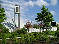 Evangelische Christuskirche
 Det nye rådhus i den gamle klosterskole
 "Gugelkapelle"
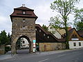 Erlanger Tor i den gamle bymur
Eksterne henvisninger
- Information om landsbyen Ermreuth Arkiveret 11. april 2008 hos Wayback Machine
Medier brugt på denne side
Germany adm location map.svg
(c) Karte: NordNordWest, Lizenz: Creative Commons by-sa-3.0 de
Location map of Germany
(c) Karte: NordNordWest, Lizenz: Creative Commons by-sa-3.0 de
Location map of Germany

Oberes-Schwabachtal-Ermreuth-Rödlas-16-05-2005.jpeg
Forfatter/Opretter: Daniel Arnold, Licens: CC BY-SA 3.0
A view from a point next to the village of Kasberg down into the upper Schwabach valley with the "Brand" / "Hetzlas" (mountain) behind. In the middle of the image you can see the two villages Ermreuth and Rödlas (on the image you see them as one village as they're grown together).

Neunkirchen-am-Brand-St.-Michaelkirche.jpeg
Forfatter/Opretter: Daniel Arnold, Licens: CC BY-SA 3.0
Die St. Michaleskirche des ehemaligen Klosters
Forfatter/Opretter: Daniel Arnold, Licens: CC BY-SA 3.0
Die St. Michaleskirche des ehemaligen Klosters
Neunkirchena-Brand-Kirchplatz.jpeg
Forfatter/Opretter: Daniel Arnold, Licens: CC BY-SA 3.0
Zentrum von Neunkirchen mit Fachwerkhäusern und dem alten Amtshaus an der St.-Michaelskirche (rechts außerhalb des Bildes)
Forfatter/Opretter: Daniel Arnold, Licens: CC BY-SA 3.0
Zentrum von Neunkirchen mit Fachwerkhäusern und dem alten Amtshaus an der St.-Michaelskirche (rechts außerhalb des Bildes)

Neunkirchen-am-Brand-Erlanger-Tor.jpeg
Forfatter/Opretter: Daniel Arnold, Licens: CC BY-SA 3.0
Erlanger Tor (town gate) of Neunkirchen am Brand (Bavaria, Germany) viewed from outside the old town.
Forfatter/Opretter: Daniel Arnold, Licens: CC BY-SA 3.0
Erlanger Tor (town gate) of Neunkirchen am Brand (Bavaria, Germany) viewed from outside the old town.

Neunkirchen-am-Brand-Zehntscheune.jpeg
Forfatter/Opretter: Daniel Arnold, Licens: CC BY-SA 3.0
Zehntscheune in Neunkirchen am Brand, Bavaria, Germany.
Forfatter/Opretter: Daniel Arnold, Licens: CC BY-SA 3.0
Zehntscheune in Neunkirchen am Brand, Bavaria, Germany.


Neunkirchen-am-Brand-Christuskirche-Umgebung.jpeg
Forfatter/Opretter: Daniel Arnold, Licens: CC BY-SA 3.0
Surounding of the Christuskirche (Lutheran curch) in Neunkirchen am Brand (Bavaria, Germany) viewed angular.
Forfatter/Opretter: Daniel Arnold, Licens: CC BY-SA 3.0
Surounding of the Christuskirche (Lutheran curch) in Neunkirchen am Brand (Bavaria, Germany) viewed angular.

Neunkirchen-am-Brand-Grabkapelle.jpeg
Forfatter/Opretter: Daniel Arnold, Licens: CC BY-SA 3.0
Grabkapelle (Catholic cemetery chapel) in Neunkirchen am Brand (Bavaria, Germany).
Forfatter/Opretter: Daniel Arnold, Licens: CC BY-SA 3.0
Grabkapelle (Catholic cemetery chapel) in Neunkirchen am Brand (Bavaria, Germany).

Neunkirchen-am-Brand-neues-Rathaus.jpeg
Forfatter/Opretter: Daniel Arnold, Licens: CC BY-SA 3.0
New town hall of Neunkirchen am Brand (Bavaria, Germany) located at the old convent school.
Forfatter/Opretter: Daniel Arnold, Licens: CC BY-SA 3.0
New town hall of Neunkirchen am Brand (Bavaria, Germany) located at the old convent school.