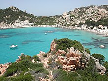
Nationalpark Arkipelag La Maddalena
| Parco Nazionale dell'Arcipelago di La Maddalena | |
|---|---|
| Nationalpark Arkipelag La Maddalena | |
IUCN kategori II (nationalpark) | |
 Maddalena Archipelago | |
| Nationalparkens beliggenhed i Italien | |
| Sted | Sardinien |
| Koordinater | 41°14′45″N 9°24′43″Ø / 41.24583°N 9.41194°ØKoordinater: 41°14′45″N 9°24′43″Ø / 41.24583°N 9.41194°Ø |
| Areal | 201,46 km² |
| Etableret | 1994 |
| Styrende organ | Ministero dell'Ambiente |
| http://www.parks.it/parco.nazionale.arcip.maddalena/Epar.php | |
Nationalpark Arkipelag La Maddalena. eller på italiensk Arcipelago di La Maddalena National Park er en nationalpark der omfatter det meste af øgruppen Arkipelag La Maddalena ud for nordkysten af Sardinien i Italien. Parken blev etableret 1. april 1994 og omfatter et areal på 201,46 km² med 180 kilometer kyst. Området omfatter alle øer i kommunen La Maddalena. Øgruppen omfatter ud over hovedøen La Maddalena med hovedbyen La Maddalena, seks andre større øer (rækkefølge efter størrelse): Caprera, Spargi, Santo Stefano, Santa Maria, Budelli og Razzoli. Kun Maddalena, Caprera og S. Stefano er beboede.
Nationalparkens område vil blive en vigtig del af en kommende Bocche di Bonifacio international marinpark,[1] og en vigtig del af det europæiske netværk af områder af stor miljømæssig betydning.
Galleri
Se også
Henvisninger
- ^ Yearbook of the Italian Parks 2005, edited by Comunicazione in association with Federparchi and the Italian State Tourism Board ISBN 88-7585-011-9
- Parco Nazionale dell'Arcipelago di La Maddalena (engelsk)
- Parco nazionale dell'Arcipelago di La Maddalena in Italy på protectedplanet.net (engelsk)
- La-Maddalena-Archipel Arkiveret 22. december 2017 hos Wayback Machine (tysk)
Medier brugt på denne side
Forfatter/Opretter: ColdShine, Licens: CC BY-SA 2.5
Map of national parks of Italy.
Forfatter/Opretter: Paolo De Carolis, Licens: CC BY-SA 3.0
This is a photo of a monument which is part of cultural heritage of Italy. This monument participates in the contest Wiki Loves Monuments Italia . See authorisations.
Forfatter/Opretter: MARIAPIAD, Licens: CC BY-SA 3.0
This is a photo of a monument which is part of cultural heritage of Italy. This monument participates in the contest Wiki Loves Monuments Italia . See authorisations.
Forfatter/Opretter: Paolo De Carolis, Licens: CC BY-SA 3.0
This is a photo of a monument which is part of cultural heritage of Italy. This monument participates in the contest Wiki Loves Monuments Italia . See authorisations.
Forfatter/Opretter: Paolo De Carolis, Licens: CC BY-SA 3.0
This is a photo of a monument which is part of cultural heritage of Italy. This monument participates in the contest Wiki Loves Monuments Italia . See authorisations.
Forfatter/Opretter: Mattia.dipaolo, Licens: CC BY-SA 3.0
This is a photo of a monument which is part of cultural heritage of Italy. This monument participates in the contest Wiki Loves Monuments Italia . See authorisations.
Forfatter/Opretter: Ketch, Licens: CC BY-SA 3.0
This is a photo of a monument which is part of cultural heritage of Italy. This monument participates in the contest Wiki Loves Monuments Italia . See authorisations.
Forfatter/Opretter: Eric Gaba (Sting - fr:Sting) and NordNordWest, Licens: CC BY-SA 3.0
Blank physical map of Italy including the 08-2009 modification of the boundary between Emilia-Romagna and Marche regions, for geo-location purpose.
Forfatter/Opretter: Aldo Ardetti, Licens: CC BY-SA 3.0
Il mare dell'Isola di Spargi


