Nagaland

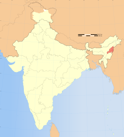
Delstaten Nagalands placering

Nagaland (hindi: नागालैंड) er en delstat i det nordøstlige Indien. Nagaland grænser mod vest til delstatene Assam og Manipur, i nordøst mod Arunachal Pradesh og mod øst mod Myanmar.

Delstatens hovedstad er Kohima med 93.000 indbyggere, men den største by er Dimapur med omkring 202.000 indbyggere.

Nagaland er en af de mindste delstater i Indien med et areal på 16.579 km² med en befolkning på 1.988.636 (2001), svarende til en befolkningstæthed på 120 mennesker pr km².

En headhunter i Longwa landsby, Nagaland

Eksterne links


Commons-logo.svg
Wikimedia Commons har medier relateret til:

Koordinater: 26°N 95°Ø / 26°N 95°Ø / 26; 95

Medier brugt på denne side

India Nagaland locator map.svg
Forfatter/Opretter:
This Image was created by User:PlaneMad.
  • If you are using the image under the creative commons share alike license please credit the photo CC-by-sa PlaneMad/Wikimedia and include a link to this page. No explicit permission is needed from me, but id appreciate an email if my work has been of help to you.
  • If you dont want to release your work under a creative commons license, please mail me at arun.planemad@gmail.com or catch me at my Website to negotiate a custom license as per your needs.
, Licens: CC BY-SA 3.0
Locator map of the state of Nagaland, India with district boundaries.
A headhunter in longwa village, nagaland.jpg
Forfatter/Opretter: Avantikac98, Licens: CC BY-SA 4.0
The Mon district of Nagaland is where the Konyak tribe lives. Konyak people are (in)famous for their ancient tradition of headhunting during village raids. Those who successfully hunted heads were given face tattoos to make them look more masculine and scary. The tradition has long been banned since the advent of Christianity in Nagaland, but a last few head hunters from a bygone era still live to tell the tale today.