Monmouthshire
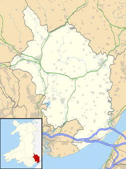
Monmouthshire (walisisk: Sir Fynwy) er et hovedområde i det sydøstlige Wales. Navnet kommer fra det historiske county af samme navn; det moderne county dækker den østlige tre-femtedele af det historiske county.
I 2017 havde countiet 95.164 indbyggere. Den største by Abergavenny, mens andre større byer og landsbyer er Caldicot, Chepstow, Monmouth, Magor og Usk. Countiet grænser op til Torfaen, Newport og Blaenau Gwent mod vest; Herefordshire og Gloucestershire mod øst; og Powys mod nord.
Seværdigheder

- Chepstow Castle[1]
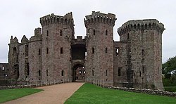
- Raglan Castle[2]
- Monmouth[3]
- Trellech[4]
- Abergavenny Castle[5]
- Wye Valley[6]
- Black Mountains[7]
- Brecon Beacons National Park[8]
- White Castle[9]
- Skenfrith Castle[10]
- Grosmont Castle[11]
- Three Castles Walk[12]
- Offa's Dyke[13]
- Llanthony Priory[14]
- Tintern Abbey[15]
- Usk[16]
- Usk Valley Walk[17]
- Abergavenny[18]
- Monmouthshire and Brecon Canal[19]
- Marches Way[20]
- Monnow Valley Walk[21]
- Caldicot Castle[22]
- The Kymin[23]
- The Sugar Loaf[24]
Scenic Railway Line:
- Gloucester to Newport Line
Referencer
- ^ "Chepstow Castle from the 1816 Bridge:: OS grid ST5394 :: Geograph Britain and Ireland - photograph every grid square!". Geograph.org.uk. Hentet 21. maj 2011.
- ^ "Raglan Castle:: OS grid SO4108 :: Geograph Britain and Ireland - photograph every grid square!". Geograph.org.uk. Hentet 21. maj 2011.
- ^ "Monnow Bridge, Monmouth:: OS grid SO5012 :: Geograph Britain and Ireland - photograph every grid square!". Geograph.org.uk. Hentet 21. maj 2011.
- ^ "Harold's Stones, Trellech:: OS grid SO4905 :: Geograph Britain and Ireland - photograph every grid square!". Geograph.org.uk. Hentet 21. maj 2011.
- ^ "Abergavenny Castle:: OS grid SO2913 :: Geograph Britain and Ireland - photograph every grid square!". Geograph.org.uk. Hentet 21. maj 2011.
- ^ "Wye Valley View from Eagle's Nest on Wynd Cliff:: OS grid ST5296 :: Geograph Britain and Ireland - photograph every grid square!". Geograph.org.uk. Hentet 21. maj 2011.
- ^ "The Sugar Loaf, near Abergavenny:: OS grid SO2718 :: Geograph Britain and Ireland - photograph every grid square!". Geograph.org.uk. Hentet 21. maj 2011.
- ^ "Looking NNE from the Sugar Loaf:: OS grid SO2620 :: Geograph Britain and Ireland - photograph every grid square!". Geograph.org.uk. Hentet 21. maj 2011.
- ^ "White Castle:: OS grid SO3716 :: Geograph Britain and Ireland - photograph every grid square!". Geograph.org.uk. Hentet 21. maj 2011.
- ^ "Skenfrith Castle:: OS grid SO4520 :: Geograph Britain and Ireland - photograph every grid square!". Geograph.org.uk. Hentet 21. maj 2011.
- ^ "Grosmont Castle:: OS grid SO4024 :: Geograph Britain and Ireland - photograph every grid square!". Geograph.org.uk. Hentet 21. maj 2011.
- ^ "The Three Castles Walk:: OS grid SO4421 :: Geograph Britain and Ireland - photograph every grid square!". Geograph.org.uk. Hentet 21. maj 2011.
- ^ "Devil's Pulpit:: OS grid ST5499 :: Geograph Britain and Ireland - photograph every grid square!". Geograph.org.uk. Hentet 21. maj 2011.
- ^ "Llanthony Priory:: OS grid SO2827 :: Geograph Britain and Ireland - photograph every grid square!". Geograph.org.uk. Hentet 21. maj 2011.
- ^ "Tintern Abbey:: OS grid SO5300 :: Geograph Britain and Ireland - photograph every grid square!". Geograph.org.uk. 30. marts 2005. Hentet 21. maj 2011.
- ^ "View from Usk Castle:: OS grid SO3700 :: Geograph Britain and Ireland - photograph every grid square!". Geograph.org.uk. Hentet 21. maj 2011.
- ^ "Clytha Castle:: OS grid SO3608 :: Geograph Britain and Ireland - photograph every grid square!". Geograph.org.uk. Hentet 21. maj 2011.
- ^ "Market Hall clock tower, Abergavenny:: OS grid SO2914 :: Geograph Britain and Ireland - photograph every grid square!". Geograph.org.uk. Hentet 21. maj 2011.
- ^ "Monmouthshire & Brecon Canal, Govilon:: OS grid SO2713 :: Geograph Britain and Ireland - photograph every grid square!". Geograph.org.uk. Hentet 21. maj 2011.
- ^ "Stream at Dolydd y Castell, Abergavenny:: OS grid SO3013 :: Geograph Britain and Ireland - photograph every grid square!". Geograph.org.uk. 1. april 2007. Hentet 21. maj 2011.
- ^ "The Monnow Valley:: OS grid SO4323 :: Geograph Britain and Ireland - photograph every grid square!". Geograph.org.uk. Hentet 21. maj 2011.
- ^ "Caldicot Castle:: OS grid ST4888 :: Geograph Britain and Ireland - photograph every grid square!". Geograph.org.uk. Hentet 21. maj 2011.
- ^ "The Round House, The Kymin, Monmouth:: OS grid SO5212 :: Geograph Britain and Ireland - photograph every grid square!". Geograph.org.uk. Hentet 21. maj 2011.
- ^ "Sugar Loaf and Usk Valley". National Trust.
Eksterne henvisninger
| Spire |
Medier brugt på denne side
Forfatter/Opretter:
- Wales_location_map.svg: NordNordWest
- Flag_of_Wales_2.svg:
- derivative work: Fry1989 eh? 20:04, 8 December 2011 (UTC)
Flag map of Wales
Contains Ordnance Survey data © Crown copyright and database right, CC BY-SA 3.0
Blank map of Monmouthshire, UK with the following information shown:
- Administrative borders
- Coastline, lakes and rivers
- Roads and railways
- Urban areas
Equirectangular map projection on WGS 84 datum, with N/S stretched 160%
Geographic limits:
- West: 3.20W
- East: 2.60W
- North: 52.00N
- South: 51.50N


