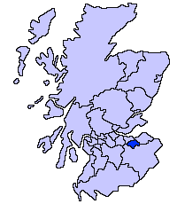
Midlothian
| Midlothian | |
|---|---|
 | |
| Geografi | |
| Areal: - Totalt - % vand | 354 km² ? % |
| Adm. center | Dalkeith |
| ISO 3166-2-kode: | GB-MLN |
| ONS-kode: | 00QW |
| Demografi | |
| Befolkning: - Totalt (29. april 2001) - Tæthed | 80 941 229 / km² |
| Grevskabet Mid Lothian | |
 | |
Midlothian er en af Skotlands kommuner. Det grænser op mod South Lanarkshire, Scottish Borders, East Lothian, City of Edinburgh og West Lothian. Administrationsbyen er Dalkeith.
Der findes også et grevskab med samme navn. For dette bruges ofte den ældre stavemåde Mid Lothian, eller det alternative navn Edinburghshire. Som sidstnævnte antyder, omfatter det også City of Edinburgh. Det grænser op mod West Lothian, Lanarkshire, Peeblesshire, Berwickshire og East Lothian.
Byer og landsbyer

Bebyggelser i både det historiske og moderne Midlothian
- Arniston
- Auchendinny
- Bilston
- Bonnyrigg
- Borthwick
- Carrington
- Cornbank
- Cousland
- Crichton
- Dalkeith
- Danderhall
- Deanburn
- Dewartown
- Easthouses
- Easter Howgate
- Edgehead
- Eight Mile Burn
- Eskbank
- Fala
- Ford
- Gorebridge
- Gowkshill
- Hillend
- Hopefield
- Howgate
- Lasswade
- Leadburn
- Loanhead
- Mayfield
- Millerhill
- Milton Bridge
- Newbattle
- Newtongrange
- Nine Mile Burn
- North Middleton
- Pathhead
- Penicuik
- Polton
- Rosewell
- Roslin
- Shawfair
- Silverburn
- Straiton
- Temple
- Whitehill
- Woodburn
Bosættelser i det historiske Midlothian, der nu tilhører andre områder
Overført til City of Edinburgh
- Abbeyhill
- Alnwickhill
- Ardmillan
- Baberton
- Balerno
- Balgreen
- Bankhead
- Barnton
- Beechmount
- Bingham
- Blackford
- Blackhall
- Bonaly
- Bonnington
- Braepark
- Broomhouse
- Broughton
- Brunstane
- Bruntsfield
- Bughtlin
- Burdiehouse
- Burghmuirhead
- The Calders
- Cameron Toll
- Cammo
- Canongate
- Canonmills
- Chesser
- Church Hill
- Clermiston
- Comely Bank
- Comiston
- Corstorphine
- Cowgate
- Craigcrook
- Craigentinny
- Craigleith
- Craiglockhart
- Craigmillar
- Craigour
- Cramond
- Crewe Toll
- Currie
- Curriehill
- Dalmahoy
- Dalry
- Davidson's Mains
- Dean Village
- Drumbrae
- Drylaw
- Duddingston
- Dumbiedykes
- East Craigs
- East Pilton
- Edinburgh
- Edinburgh Park
- Fairmilehead
- Ferniehill
- Ferry Road
- Firrhill
- Forrester
- Fountainbridge
- Gilmerton
- Gogar
- Gogarloch
- Goldenacre
- Gorgie
- Gracemount
- The Grange
- Granton
- Grassmarket
- Greenbank
- Greendykes
- Greenhill
- Haymarket
- Hermiston
- Holy Corner
- Holyrood
- Hunter's Tryst
- The Inch
- Ingliston
- Inverleith
- Jock's Lodge
- Joppa
- Juniper Green
- Kaimes
- Kingsknowe
- Lauriston
- Leith
- Liberton
- Little France
- Lochend
- Lochrin
- Longstone
- Marchmont
- Maybury
- Mayfield
- Meadowbank
- Merchiston
- Moredun
- Morningside
- Mortonhall
- Mountcastle
- Muirhouse
- Murrayfield
- Newbridge
- Newcraighall
- Newhaven
- Newington
- Niddrie
- Northfield
- Oxgangs
- Parkgrove
- Parkhead
- Piershill
- Pilrig
- Pilton
- Polworth
- Portobello
- Powderhall
- Prestonfield
- Ratho
- Ratho Station
- Ravelston
- Redford
- Restalrig
- Riccarton
- Roseburn
- Saughton
- Sciennes
- Seafield
- Shandon
- Sighthill
- Silverknowes
- Slateford
- South Gyle
- Stenhouse
- Stockbridge
- Swanston
- Tollcross
- Torphin
- Trinity
- Turnhouse
- Warriston
- West Coates
- West Craigs
- West End
- Westfield
- Wester Broom
- Wester Hailes
- Western Harbour
- West Pilton
- Willowbrae
Overført til East Lothian

- Fisherrow
- Inveresk
- Monktonhall
- Musselburgh
- Wallyford
- Whitecraig
Overført til Scottish Borders
- Heriot
- Stow of Wedale
Overført til West Lothian
- Adambrae
- Addiewell
- Bellsquarry
- Breich
- Cobbinshaw
- Craigshill
- Dedridge
- East Calder
- Harburn
- Howden
- Kirknewton
- Mid Calder
- Murieston
- Polbeth
- Pumpherston
- West Calder
- Wilkieston
Seværdigheder
- Arniston House
- Borthwick Castle
- Castlelaw Fort
- Crichton Castle
- Dalhousie Castle
- Dalkeith Palace
- Flotterstone
- Hawthornden Castle
- Midlothian Snowsports Centre, Hillend
- National Mining Museum
- Loanhead Memorial Park
- Mavisbank House
- Melville Castle
- Newbattle Abbey
- Pentland Hills
- Roslin Castle
- Roslin Glen Country Park
- Roslin Institute
- Rosslyn Chapel
- Tyne-Esk Walk
- Vogrie Country Park
- Wallace's Cave
| Spire |
Koordinater: 55°53′39″N 3°04′07″V / 55.894166666667°N 3.0686111111111°V
|
| Infoboks uden skabelon Denne artikel har en infoboks dannet af en tabel eller tilsvarende. |
Medier brugt på denne side
Forfatter/Opretter: Tango Project], Gnome, og VisualEditor team, Licens: GPL
Icon used to indicate a list
Forfatter/Opretter:
- Scotland_location_map.svg: NordNordWest
- Flag_of_Scotland.svg: Kbolino
- derivative work: Fry1989 (talk) 21:12, 25 January 2011 (UTC)
Flag map of Scotland
Forfatter/Opretter: MrPenguin20, Licens: CC BY-SA 4.0
Map showing the current council area of Midlothian (dark blue) over the former territory comprising the county of Midlothian (light blue),
Town bridge, River Esk, Musselburgh, East Lothian, Scotland


