McMurdosundet

McMurdosundet er et cirka 60 km (maksimum 74 km) bredt og 148 km langt sund mellem Ross Island og Victoria Land i Antarktis. Mod syd grænser sundet op mod Rossbarrieren og har derfor mere karakter af en bugt. McMurdosundet blev opdaget i 1841 af James Clark Ross under dennes sydpolsekspedition.
McMurdosundet er en vigtig adgangsvej til det antarktiske kontinent. Flere sydpolsekspeditioner har haft baser ved McMurdosundet, blandt andet ekspeditionerne under ledelse af Robert F. Scott og Ernest Shackleton. Ned til sundet, på Rossøen, ligger Antarktis' største samfund, den amerikanske forskningsstation McMurdo Station.
Galleri
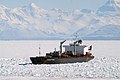
Skib på vej gennem McMurdosundet
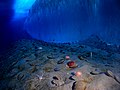
Under vandet i McMurdosundet. Til højre isbræmmen på havbunden

Satellitfoto af McMurdosundet med Ross Island og McMurdostationen indtegnet
Eksterne links
- McMurdo Sound Encyclopaedia Britannica Online
- Virtual Tour – McMurdo Station, Antarctica Arkiveret 1. marts 2011 hos Wayback Machine University of Chicago
| |||||||||||||||||||||||||||||||||||||||||||||||||||||
Koordinater: 77°30′S 165°00′Ø / 77.500°S 165.000°Ø
| Spire Denne artikel om antarktisk geografi er en spire som bør udbygges. Du er velkommen til at hjælpe Wikipedia ved at udvide den. |
|
Medier brugt på denne side
.svg)
Forfatter/Opretter: Heraldry, Licens: CC BY-SA 3.0
Antarctica (orthographic projection)


High Resolution image of McMurdo Station
Karte des McMurdo-Sunds mit den Trockentälern

Image of an ice wall and the ocean floor adjacent to remote-controlled photographic equipment at Explorer's Cover, New Harbor, McMurdo Sound. An underwater camera is connected by cable to onshore facilities, which upload images to the Internet via radio signals.
main visible species :
the antarctic scallop (Adamussium colbecki)
the common antarctic sea urchin (Sterechinus neumayeri)
a stalk-like bush sponge (Homaxinella balfourensis)
a brittlestar (Ophionotus victoriae)

The fuel tanker Lawrence H. Gianella at Winters Quarters Bay at McMurdo Station, Antarctica; is one of several cargo ships used to re-supply the U.S. base and New Zealand's nearby Scott Base.