Mars Reconnaissance Orbiter
| Mars Reconnaissance Orbiter | ||
 En kunstners opfattelse af Mars Reconnaissance Orbiter i et elliptisk lavt kredsløb om Mars | ||
| Rumsonde | ||
|---|---|---|
| Organisation: | NASA | |
| Primære Leverandører: | Lockheed Martin, University of Arizona, Johns Hopkins University Applied Physics Laboratory, Agenzia Spaziale Italiana, Malin Space Science Systems, Jet Propulsion Laboratory | |
| Mission: | At studere Mars i stor detalje | |
| I kredsløb om: | Mars | |
| Instrumenter: | HiRISE, CTX, MARCI, CRISM, MCS, SHARAD | |
| Opsendelsesdato: | 12. august 2005 | |
| Opsendelsessted: | Rampe 41 ved Cape Canaveral Air Force Station | |
| Opsendelsesraket: | Atlas V-401 raket | |
| Missionens afslutning: | 31. december 2010 | |
| Forløbet: | 15 år, 8 måneder og 5 dage | |
| NSSDC ID: | 2005-029A | |
| Webside: | Mars Reconnaissance Orbiter | |
| Masse: | 2180kg med brændstof | |
| Energiforsyning: | To solpaneler, 2000 Watt | |
NASAs Mars Reconnaissance Orbiter (MRO) er en rumsonde designet til at udføre udforskning af Mars fra et kredsløb om planeten. MRO blev bygget af Lockheed Martin sammen med Jet Propulsion Laboratory og havde en samlet pris på 720 millioner dollars. Den blev opsendt 12 august 2005 og nåede frem til Mars hvor den gik i kredsløb 10 marts 2006. Efter at have justeret sit kredsløb om Mars i seks måneder nåede sonden sit endelige kredsløb i november 2006 og den begyndte kort derefter den videnskabelige mission.
For at kunne analysere Mars har MRO både kameraer, spektrometre og radar med. Dette muliggør analyser af både landskabsformer, stratigrafi, mineraler og is. MRO baner vejen for fremtidige rumsonder til Mars ved at kunne overvåge vejr- og overfladeforhold og studere potentielle landingingssteder for fremtidige landere til den røde planet. MRO fungerer også som kommunikationsforbindelse mellem jorden og Mars for nuværende og fremtidige landere. I løbet af sin levetid vil MRO sende mere data fra Mars til jorden end alle tidligere interplanetariske rumsonder tilsammen.
MRO tilsluttede sig tre andre rumsonder og to landere, der udforskede Mars: Mars Global Surveyor, Mars Express, 2001 Mars Odyssey, og de to Mars Exploration Rovers. Siden har Mars Global Surveyor dog afsluttet sin mission.
Falkeøje

MRO er udstyret med en kraftig kikkert der kan opdage en fodbold på marsoverfladen. HiRISE har bl.a. taget billeder af marslanderne – i første omgang de amerikanske, men senere skal den også kikke på nedstyrtede sovjetiske og den europæiske Beagle-2.

Marsrobotten Opportunity fra rummet
Phoenix-landeren i faldskærm foran Heimdall
Phoenix på overfladen
| |||||||||||||||||||||||||||||
| ||||||||||||||||||||||||||||||||
| Spire Denne artikel om rumfart er en spire som bør udbygges. Du er velkommen til at hjælpe Wikipedia ved at udvide den. |
Medier brugt på denne side

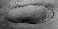
Original Caption Released with NASA Image:
Mars Reconnaissance Orbiter over Nilosyrtis Mensae - NASA's Mars Reconnaissance Orbiter passes above a portion of the planet called Nilosyrtis Mensae in this artist's concept illustration. NASA plans to launch this multipurpose spacecraft in August 2005 to advance our understanding of Mars through detailed observation, to examine potential landing sites for future surface missions and to provide a high-data-rate communications relay for those missions.

Image taken by Mars Reconnaissance Orbiter showing descent of Phoenix with a crater in the background.
Original caption from NASA:
"Mars Reconnaissance Orbiter's High Resolution Imaging Science Experiment (HiRISE) camera acquired this image of Phoenix hanging from its parachute as it descended to the Martian surface. Shown here is a 10 kilometer (6 mile) diameter crater informally called "Heimdall," and an improved full-resolution image of the parachute and lander. Although it appears that Phoenix is descending into the crater, it is actually about 20 kilometers (about 12 miles) in front of the crater. Given the position and pointing angle of MRO, Phoenix is at about 13 km above the surface, just a few seconds after the parachute opened. This image shows some details of the parachute, including the gap between upper and lower sections. At the time of this observation, MRO had an orbital altitude of 310 km, traveling at a ground velocity of 3.4 kilometers/second, and a distance of 760 km to the Phoenix lander.

A drawing of NASA's Space Shuttle Challenger. Image provided by Dryden Flight Research Center at Edwards Air Force Base, California. See [1], specifically EG-0076-04.eps.

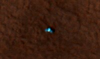
The butterfly-like object in this picture is NASA's Phoenix Mars Lander, as seen from above by NASA's Mars Reconnaissance Orbiter.
HiRISE camera of the Mars Reconnaissance Orbiter (NASA). Original description: The high resolution imaging science experiment (Hirise) is one of six science instruments for NASA's Mars Reconnaissance Orbiter. The orbiter is scheduled for launch in August 2005. This instrument is designed to produce the most detailed pictures of Mars ever taken from orbit, revealing surface details as small as a meter (3 feet) across. In this photograph, a worker at Ball Aerospace and Technology Corp., Boulder, Colo., prepares the instrument before it is shipped for attachment to the spacecraft

Summary- Mars Rover "Opportunity" at Victoria crater, as viewed from orbit on October 3, 2006. Note the shadow of the rover's camera mast.
Original JPL site caption: "This image from the High Resolution Imaging Science Experiment on NASA's Mars Reconnaissance Orbiter shows the Mars Exploration Rover Opportunity near the rim of "Victoria Crater." Victoria is an impact crater about 800 meters (half a mile) in diameter at Meridiani Planum near the equator of Mars. Opportunity has been operating on Mars since January, 2004. Five days before this image was taken, Opportunity arrived at the rim of Victoria, after a drive of more than 9 kilometers (over 5 miles). It then drove to the position where it is seen in this image.
Shown in the image are "Duck Bay," the eroded segment of the crater rim where Opportunity first arrived at the crater; "Cabo Frio," a sharp promontory to the south of Duck Bay; and "Cape Verde," another promontory to the north. When viewed at the highest resolution, this image shows the rover itself, wheel tracks in the soil behind it, and the rover's shadow, including the shadow of the camera mast. After this image was taken, Opportunity moved to the very tip of Cape Verde to perform more imaging of the interior of the crater.
This view is a portion of an image taken by the High Resolution Imaging Science Experiment (HiRISE) camera onboard the Mars Reconnaissance Orbiter spacecraft on Oct. 3, 2006. The complete image is centered at minus7.8 degrees latitude, 279.5 degrees East longitude. The range to the target site was 297 kilometers (185.6 miles). At this distance the image scale is 29.7 centimeters (12 inches) per pixel (with 1 x 1 binning) so objects about 89 centimeters (35 inches) across are resolved. North is up. The image was taken at a local Mars time of 3:30 PM and the scene is illuminated from the west with a solar incidence angle of 59.7 degrees, thus the sun was about 30.3 degrees above the horizon."